Powder Mountain

Uncrowded Powder Mountain

[Editor Note: SeniorsSkiing.com is asking our readers to contribute to support our online magazine. Yes, we have grown in the number of subscribers and advertisers. But our expenses have also grown. You can help us defray some of these expenses by helping us out with a donation.]

Support SeniorsSkiing.com by clicking here.

______________________________________________________

500 Inches Of Snow, 8,000+ Acres, And No Crowds.

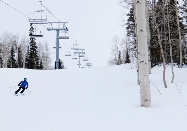
Uncrowded on a holiday weekend. Powder has plenty of room. Credit: Harriet Wallis

A Mountain Host greeted us with memorable words. “The snow here is all natural. Mother Nature makes all of it,” she said. “And it’s GMO-free,” she quipped.

We skied Powder Mountain during a recent holiday weekend when other resorts near Salt Lake City were packed to the gills, “PowMow’s” trails were not only uncrowded, they were sometimes absolutely empty. It was wonderfully relaxing. I didn’t need eyes in the back of my head. Nobody was going to run over me. And there was still patches of untracked snow from a storm nearly a week earlier.

To ensure a good experience, the mountain caps adult season passes at 3,000 and daily lift tickets to 1,500. It doesn’t accept the Ikon or other multi-resort passes. Do the math. At max capacity, every skier gets about 2 acres.

Seniors 75 and older get a free lift ticket or a season pass for $20. 

Good snow, uncrowded slopes and affordable senior prices  are just part of the equation. Powder Mountain is old school. It doesn’t do glitz. That’s it’s charm. There’s even an old fashioned blackboard where the list of upcoming bands to play in the Powder Keg bar are written in colored chalk.

Powder base lodge is unpretentious. Credit: Harriet Wallis

The day lodge is modest, the bathrooms are adequate, the cafeteria tables are set in long rows so everyone eats family style and gets acquainted with whoever sits down next to them. The lodge on the summit is similar, just smaller.

Six chairlifts serve 8,464 acres that include white knuckle slopes, aspen forests, and treeless snowfields. And in old school style, there’s a Poma. It hauls skiers up a short pitch that’s a gateway to vast terrain. Riding a Poma is a skill that older skiers remember well but younger skiers struggle to learn. After a few they get to experience what the good old days of skiing were like.

We chanced to meet Bob Leaverton, a veteran ski patroller, who has skied Powder Mountain for 35+ years. His three favorite things are: “the road, the people, and the snow.”

The last several miles up to the resort are steep, and that climb often deters visitors, he said. The people are friendly, and the snow is wonderful. Take it from a local.

For adrenaline junkies, Powder Mountain offers specialty adventures: in- and out-of bounds backcountry skiing, skin & ski, snowcat, and heli-skiing.

Historically, Frederick Cobabe accumulated the vast acreage as range for his herd of sheep. His son eventually purchased the livestock company and the land and turned it into a ski resort in 1972.

It’s currently owned by private investors who are developing an upscale community of Bauhaus-style homes set in the far reaches of the resort and linked by a network of trails and lifts that sprawl across that rolling, not steep, terrain. It can take most of the day to ski a circuit all around the resort.

But if its a powder day, do what the mountain resort is named for: Ski the powder.

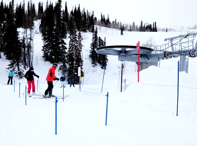
Yes, that’s the lift line. Where is everyone? Credit: Harriet Wallis

Skiing Weatherman: A Battle For The Second Half

[Editor Note: SeniorsSkiing.com is asking our readers to contribute to support our online magazine. Yes, we have grown in the number of subscribers and advertisers. But our expenses have also grown. You can help us defray some of these expenses by helping us out with a donation.]

Support SeniorsSkiing.com by clicking here.

______________________________________________________

Post-Ground Hog Day Winter Looks Like A Struggle Between Air Masses. The Winner Determines the Outcome Of The Season.

Over the past week, the Northwest and northern Rockies have been the overall winners in the snowfall lottery, continuing a trend that has been in place much of this winter. Over the eastern half of the country, it has been a struggle to pile up snowfalls. More often than not, storms have produced a mix of precip types because of an unfavorable storm track or simply just a lack of available cold air. This discussion is going to focus on the Midwest and East, because a battle for the outcome of the season in those regions is getting underway. What I mean by that is cold air is trying to push southward out of Canada but milder air associated with an upper ridge over the Southeast just won’t go away. While the next couple of weeks look snowy, there are signs that the ridge may push back and cause the storm track to shift northward late this month.

The day this is posted, a juicy storm is delivering heavy snow to a swath of the Northeast from upstate New York to western Maine. Further south, snow is also falling on the heels of another round of mixed precip. The dramatic thermal gradient between the contrasting air masses is responsible for the storm and if we look at the outlook for temperatures at 5,000 feet for Friday (2/7), you can see the essence of the fight.

The border between blue and green is the 32 degree line, which approximates where the rain/snow line is likely to be. The line has cut across the East, and at times the Midwest, in most storms this season, causing a wide variety of precip types and changeable conditions.

Last week I wrote about the cold that was finally asserting itself again, and it will be available for storms through at least mid-month, so I am confident that more snow will fall north of I-80 or so. Beyond that, I have some concerns about the staying power of any cold, based on whether or not the EPO, or Eastern Pacific Oscillation, will stay negative, where it is now. A negative EPO, where an upper ridge is found over Alaska with an upper trough underneath it and off the west coast, correlates with colder than normal temps over the eastern half of the country. That helps turn more water vapor into snowflakes rather than those less desirable forms of precipitation. There are signs that the EPO will trend positive later this month, with a trough returning to Alaska. That would inject milder Pacific air into the pattern which would squeeze the rain/snow line further north once again. Here is a forecast for the EPO going forward.

It is not forecast to go strongly positive, but still enough to potentially limit the push of the cold air from southern Canada. I will have more in my next post, but in the meantime, enjoy the snowy pattern unfolding from the Lakes to the Northeast.

Here Are The Regional Details

Northwest U.S./western Canada: Disturbances will slide down the coast along the eastern flank of the ridge over Alaska and deliver moderate to locally heavy snowfall every two or three days through the next week. The parade will continue into Week Two.

Sierra: Ridge offshore is “too close for comfort” in Week One as most storms are deflected to the east. Week Two looks more promising for fresh snow.

Northern Rockies:  Systems cutting southeast into the region will maintain enough moisture and power to keep the snows coming every few days Week One into Week Two/

Central and southern Rockies: The storms that hit the NW/N Rockies will produce a snowy Week One in the central Rockies. Light to moderate snows further south in NM/AZ. Week Two looks better.

Midwest: Two snowfalls north of I-80 in Week One will refresh the slopes nicely. Alberta Clippers will bring additional snow in Week Two. Packed powder to rule in most of this region.

Northeast/QB: Early storm sets things up for a nice weekend from central NY through Adirondacks, northern Greens/Whites and western Maine.  Same areas hit again later next week. Mixed precip south of these areas.