The Skiing Weatherman March 24, 2023

First of all, please accept my apologies for missing the last edition.  After attending a hectic three day trade show near my home here in Rhode Island, I rushed home and packed my bags for a flight to the Netherlands, where my wife and I met our first grandchild…a memorable event that I will never forget.  I simply had a brain cramp and forgot to submit an article.  Hopefully you didn’t miss it because you were out enjoying the fresh snow that FINALLY made its way to the Northeast early this month!

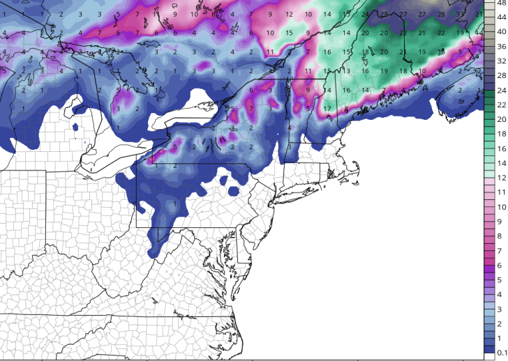
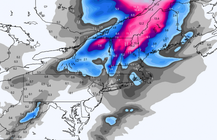
The weather pattern has unfolded pretty much the way I anticipated, although the cold air that has supported some healthy March snow amounts did not reach as far south as I thought it might.  Most of the substantial snow has fallen north of Interstate 80 and although the past few days have been mild and wet at times all the way up to the Canadian border, the pattern is about to cool down again and I believe that there will be at least a few more meaningful snowfalls across the Northeast before the curtain comes down on this season.  This weekend a relatively weak storm will move across New England with only a marginal amount of cold air with which to work, so we are looking at another elevation event that will bring mixed precip types to the Adirondacks and the mountains of northern New England and southern Quebec. The resorts north of U.S. Route 4 have the best shot at picking up a moderate amount of snow…along with some other “stuff”…but this will not be a blockbuster storm.

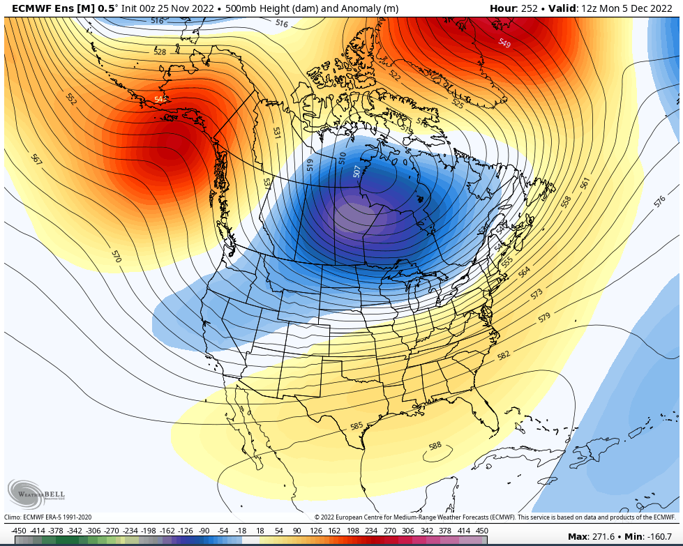
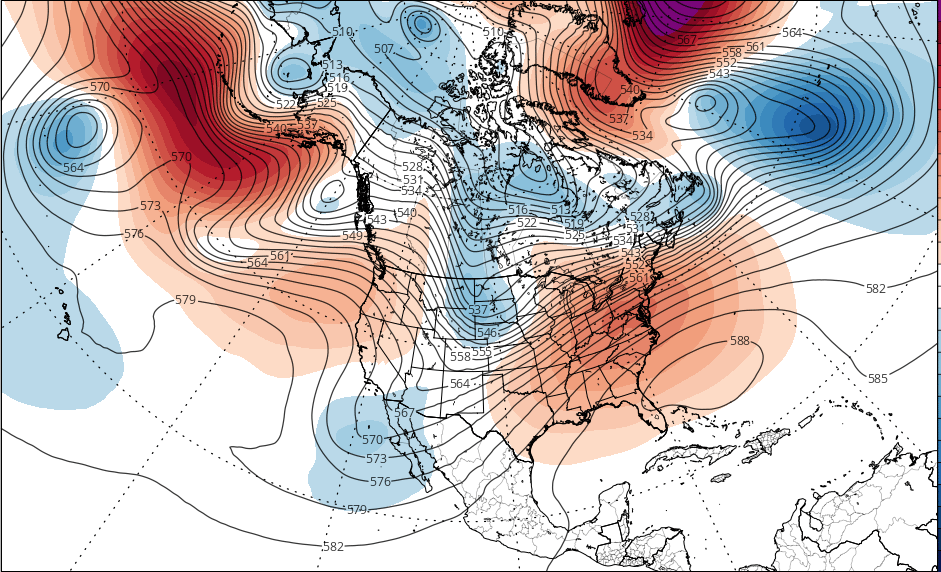
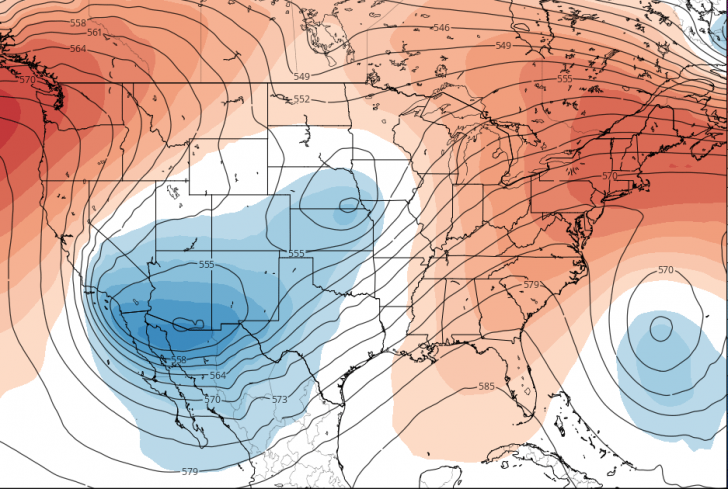
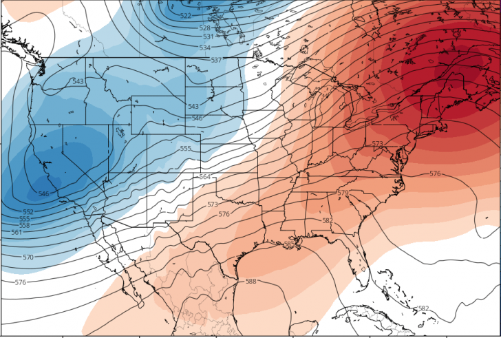
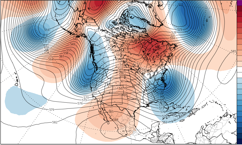
Here’s why I believe that the weather pattern still has legs in terms of cold and snow.  If you look at this jet stream forecast for April Fools Day…

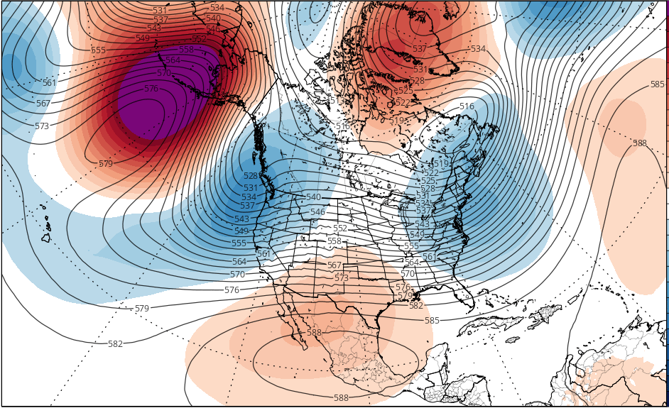
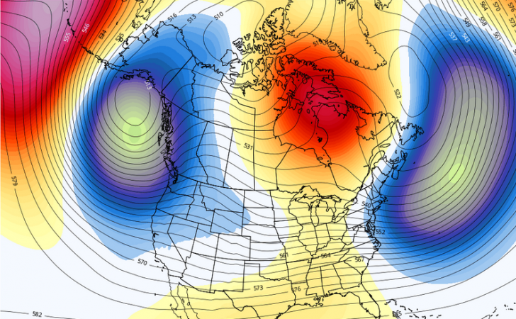
You will see an orange area over Greenland.  That is an upper level ridge, and it has hardly moved for about 3 weeks.  That blocking ridge was a product of the sudden stratospheric warming episode that I wrote about last month.  By remaining in essentially the same place, it has acted as a block against upper level troughs (the blue circulation off to its southwest) from zipping out to sea.  Instead, the troughs have been forced underneath the ridge, and many of them have moved through the Northeast this month, supporting surface lows as they spun through the region.  The troughs also break off a chunk of cold air from the high latitudes and deliver it to the lower 48.  Here’s a look at the temperature anomalies at about 5,000 feet for the same time step of the jet stream map…

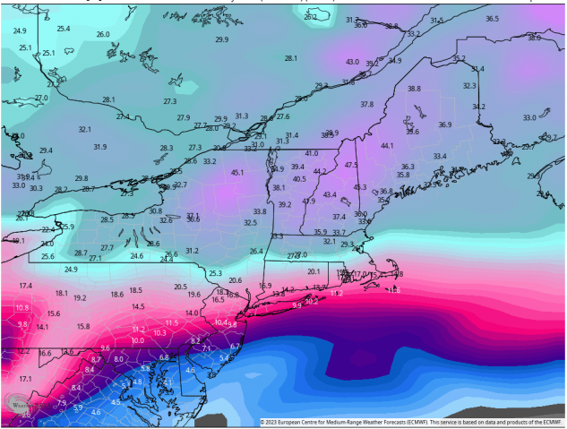
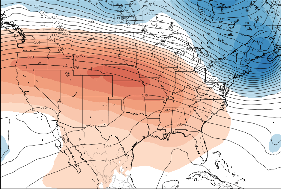
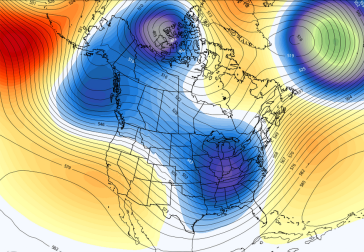
Temperatures about a mile above the surface are a very dependable proxy for forecasting surface temperatures, and the dark blue on this map suggests that air that is cold enough to limit melting and potentially support late season snow will be present as we head into next month.  If we fast forward to April 5th, we see that it looks as though those deviations from normal will only deepen…

Now, the colder air that we can reasonably expect around April 5th will be offset to an extent by the rises in normal temps that will be occurring over the next few weeks…normal highs and lows are rising 2 to 3 degrees per week in the Northeast right now.  That shot of cold will help sustain some very nice skiing and riding right through Easter weekend by the looks.

So, from where I am sitting, I remain very bullish on the prospects for winter sports for at least the next few weeks…if your timing is right, you could even sneak in a powder day or two…enjoy!!!

The Skiing Weatherman February 24, 2023 

By the time you read this, a significant snow and ice event will have moved through the Northeast, signaling the start of the pattern change that I alluded to in my last installment. The stratospheric warming event that I discussed in my last installment has matured and now it is time for us to reap the benefits.  The polar vortex has been distorted by increasing pressure from the warming above and the cold air contained in the vortex has started to spread out to the mid-latitudes in several parts of the globe.

Colder air has already built up over much of Canada, as you can see from this map of surface temp anomalies from this morning.

Although the core of the colder air is located over the western half of the continent, that cold air will be progressing eastward as we head toward March.  In addition, the cold over eastern Canada is poised to be pulled south by the circulation around any sort of low-pressure center that moves through the Northeast.  There are two other things I want you to notice about this map.  First, the zone that separates the colder than normal from the milder/warmer than normal air masses stretches from Oklahoma to central New England.  This “baroclinic zone” is the likely storm track in the near term as low pressure systems feed off the thermal contrast available for energy to support the storm.  So, there will still be rain/snow lines to be concerned with, but that zone will be sinking southward as we head into March.  Lastly, notice the current warm anomalies over Greenland…those suggest the presence of an upper level ridge overhead and indeed, if we look at this snapshot of jet stream features for the same time we see an upper ridge poking its way into Greenland from the East.

If that ridge strengthens and expands westward over the next couple of weeks, an active storm track will develop underneath it…right through the eastern United States.  If we take a look at a jet stream forecast for the end of the first weekend in March, we will see that there is model support for this idea.

The ridge will extend west into northeast Canada with a broad trough covering much of the Lower 48.  Energy will come out of the piece of the trough in the Pac Northwest, traverse the country from west to east and feed off the thermal contrast that will still exist from the Ohio Valley to the east coast…that thermal ribbon will be further south, though, and that will mean opportunities for late season snow in the central Appalachians.

Here is a very interesting frame that shows the surface pressure tendencies for the 30 day period following the maturation of a stratwarm event…

The orange area shows high pressure anomalies over Greenland and the polar regions and the blue shows a tendency for low pressure areas along the eastern seaboard…can you say “late season Nor’easter”?  A jet stream set up like the ones shown for early March is one that is very favorable for eastern snowstorms.  Furthermore, with a strong ridge over Greenland and Canada effectively blocking the progression of systems around the northern hemisphere, the pattern is likely to remain in place for an extended period…perhaps much of next month.  Last…and certainly not least, here is a forecast for bountiful snowfall through the first week in April…

Based on a multitude of factors, some of which I have laid out in this piece, I think that the amounts you see are feasible, if not likely.  Better late than never, eh?

The Skiing Weatherman February 10, 2023

In spite of last weekend’s dramatic cold outbreak over the Northeast, one that was muted at resorts further south in the mid-Atlantic states, milder than normal temperatures continue to dominate the pattern.  Not to the extent that they did in a very mild January, but enough to make every disturbance, big or small, that comes along a real nail biter in terms of rain vs. snow.  For the most part, natural snow has been confined to areas north of Interstate 90 in New York and New England, although the Catskills have cashed in a few times here in there before seeing mild air turn the precip over to something other than flakes.  There is no short-term change in sight, but all is not lost.  An infrequent event at the top of the atmosphere over the high (polar) latitudes is underway, and I believe that this phenomenon may well provide the Northeast with its most consistent snow conditions of this season from late this month through at least a good portion of March.

What’s going on high above the arctic regions is known as a Sudden Stratospheric Warming, or SSW.  At the top 1 to 3 per cent of the atmosphere, at roughly 30 miles above the surface, the air is warming rapidly, and as pressure levels grow aloft, the effect is gradually pressing down on the polar vortex that is swirling around closer to the surface at a level known as the troposphere.  Here is a graphic that illustrates the potential “before and after” of the process…

You can see the tight, symmetrical circulation over the North Pole, which is essentially what the vortex looks like right now.  The squiggly darkest blue line is what the vortex will look if the warming fully matures, spreads to the lower levels and breaks it up.  As the warming continues to descend, the vortex is attacked by the warmth at the top of the atmosphere.  Here is a graphic showing the attack at the top for the 17th

A strong bubble of warmth has pushed and distorted the vortex to the east…off its polar perch.  This next map shows the stratospheric temperatures the next day at well above normal levels…

As the process continues, the smooth and nearly circular flow of the vortex will get disrupted, so instead of having most of the cold air in the northern hemisphere bottled up near the North Pole, some of that air will get redistributed to the lower latitudes.  One of the key indicators if the warming and vortex disruption is enough to bring the Northeast a spell of consistently cold and snowy weather will be a change in direction of the flow around the pole.  Modeling does indeed forecast that change, and if it does occur, studies of prior SSWs tell us that although the main thrust of the coldest air will move into Siberia, an upper-level trough will form over eastern North America for an extended stay.  In that position, the trough will be poised to receive several shots of cold air from Siberia via a track up and over the Pole.  Here is a look at where the jet stream set up is headed toward the end of this month and beyond…

The most recent February SSW event of consequence was in 2018, and it is worth looking at the temperature anomalies at the surface that occurred in March and April of that year…

Typically, the cold effects of an SSW event last several weeks, and when combined with a dying La Nina, even longer.

An SSW is a very complex event and I hope I have been able to adequately describe it in the space available.  With another week of marginal temps about to unfold in the Northeast and the specter of yet another messy “cutter” storm moving up to the west of the region late next week, I chose to discuss the SSW today because I believe that there will be outstanding conditions to enjoy before this season is over.  The SSW that is underway is the meteorological mechanism that will get us there.

The Skiing Weatherman January 13, 2023

Happy New Year to one and all!  I hope you got some packed powder turns in during the holiday week because dry surfaces have been hard to come by during the first half of this month.  The January thaw typically comes along in the late 10’s/20’s of this month, which you can actually see in the historical data as a modest bump in observed temperatures.  This year the thaw came very early, which was unusual but not unprecedented.  An upper ridge was dominant over the East during the first week of the month, which led to a cessation in snowmaking operations as well as a pause in opportunities for meaningful natural snow.  A pattern change of sorts got underway last weekend, and mountain crews took advantage of colder temps this week to rehab terrain as we head into the MLK weekend.  A messy storm is taking an unfavorable track as we close out this week, but it will be turning colder over the weekend, so if you are skiing or riding during the holiday, you can plan on sliding through some snowmaking plumes on open terrain.

While the East has been running lean in the fresh snow department, you no doubt have been hearing about the parade of storms that have been plastering the West with fresh snow…especially the coastal ranges that get first dibs on the incoming moisture.  Those moisture laden upper troughs have been working their way out onto the Plains and then fighting with the upper ridge that has been over the East much of this month.  Most of the troughs have been deflected to the northeast, running through the Great Lakes and into Canada, and that is a track that draws moisture and mild air northward, bringing rain or mixed precip along the full length of the Appalachians.  Occasionally, one of the troughs fights its way straight east, weakening and dislodging the ridge in its path.  This scenario is what played out last weekend, leading to a colder week.   That cold air has helped to produce some snow on the front end of the system moving through the East late this week, but the track is inland, as illustrated by this slide from Friday a.m.

A low center over Albany allows milder air to reach all the way into southern Quebec, so much of the front-end snow has been washed away.  The backside of the low will bring some snow to northern New York and northern New England, and the air mass for the weekend will be seasonably cold, allowing a resumption of snowmaking.  Next week will turn somewhat milder again, but there are strong signs that a major pattern change will get underway later next week.  It won’t be a “light switch” to a cold and snowy regime, but in the transition, there is the potential for a significant snowfall on the 20th/21st that would benefit area primarily north of I-90.  South of there it will likely be a mixed precip event, with a nice shot of snowmaking temps following the passage of the low center.  Here is a look at a surface map for next Friday afternoon…

Once again, the low center will cross central New England, but there will be enough cold air around to the north of the low for a healthy snowfall.

Longer term, there are changes in the southwest Pacific and eastern Indian Ocean with respect to where thunderstorms are clustered that point to a colder than normal regime developing during the final week of January and continuing right on into February.  This season has been uneven at best and a downright dud in some parts of the East, but that thunderstorm correlation (also known as the MJO, or Madden Julian Oscillation) is an excellent winter forecast tool and I am leaning on it heavily.  Right now, I am very bullish on the second half of the season here in the East.  Here is a look at the 5,000 foot temp anomalies for the 27th, showing that the coldest air poised to dominate the East by month’s end.

For the most part, conditions are epically outstanding out west, but pummeling of storms will end in about ten days, with the northern Rockies becoming the typically La Nina favored region for continued snows…the southern Rockies resorts could still use some snow.  The northern Great Lakes are looking good, but the thaw has impacted the rest of the Midwest.   The central and southern Appalachians need some snow as they are anxiously awaiting the pattern change that I believe is on the horizon.


The Skiing Weatherman November 25, 2022

By the time you read this you may have already made your first turns in the new season.  Mother Nature has been generous with cold and natural snow from coast to coast, with the West favored in late October and early November and then the Midwest and East over the past couple of weeks.  The East is where I am going to focus my reports this season.  It makes sense because I have skied at most every resort east of the Appalachians over the years and the vast majority of my forecast clients are in that same area.

It might surprise you to know that the FIRST resort to open in the East this year was Sugar Mountain, NC.  When early season cold is short supply, elevation matters, and Sugar’s base is right around 4,000 feet.  Since they started turning lifts mid-month, several dozen resorts have joined in the fun, and many of them are already sporting double digit trail counts with multiple top to bottom routes open.  Everything is set up for one of the busiest Thanksgiving weekends in many years, but there is just one problem…the weather.

The early season cold outbreak from Canada has just about run its course, and for the next ten days or so…through roughly 12/6…any cold air masses that move through the East will be transient, and generally confined to the resorts of NY and New England.  As Black Friday gets underway, a weakening low pressure system and cool front are moving across the spine of the Appalachians and the passage of that system will lead to a round of light rain.  Saturday will be the best day of the weekend to get out on the slopes, but another low will cut up through the eastern Great Lakes and then cross central New England Sunday and Sunday night.  There won’t be cold air around to support snow, so Sunday looks wet…not the greatest news for Day 2 of the Women’s World Cup at Killington.

Temperatures will be quite variable over the next ten days as relatively weak disturbances track into the Lakes and then run along the U.S. Canadian border…an unfavorable track for snow and cold except for northern Ontario and northern Quebec.  Snowmaking windows will be small, but there will be several along the way.  The pattern will change at the end of the first week of December, though.  Why?  Well, first there is the EPO, or Eastern Pacific Oscillation.  The EPO is an index based on the relative positions of upper level ridges and troughs over the northern Pacific Ocean.  When it is negative, we find a ridge over Alaska and British Columbia and a trough downstream over central North America.  The clockwise flow around the ridge directs very cold air from the high latitudes southeastward into the counter-clockwise circulation around the trough, leading to an intrusion of very cold air into the lower 48.  Even if the main thrust of the cold is into the center of the country, it will spread out and reach the east coast.  Here is the forecast for the EPO over the next two weeks…

The correlation between a negative EPO and cold in the East is a strong one and you can see that the EPO is consistently negative, suggesting a change in the temperature regime.  Supporting that idea is the outlook for the NAO, another ingredient of the “alphabet soup” of indices that I use to sort out winter pattern changes.  The North Atlantic Oscillation is built on the pressure differential between Greenland and the Azores.  When pressures are high over Greenland, the jet stream pattern gets blocked up, often with an upper trough setting up shop over the Northeast, where it can draw cold air south from Canada.  Here is the two-week forecast for the NAO…

If we take a quick look at the jet stream setup anticipated for 10 days from now, you can see that the pieces are in place for a return to colder weather…the ridges over Alaska and Greenland, with a trough over central Canada poised to deliver a fresh cold air mass to the eastern U.S. as it tracks southeastward.

The season is off to a fast start, but trail count expansion will pause before picking up the pace again about ten days from now.

The Skiing Weatherman-January 21, 2022

East stays stormy…snow returns to the West

As we approach the approximate halfway point in the skiing/riding season, the slopes in all regions of the U.S. and adjacent to Canada are in good condition, with the western half of the continent still benefitting from the astounding amounts of snow that fell in late December.  This season got off to a roaring start in the West and a sluggish one in the East, but the jet stream pattern that delivers cold and storms has favored the Midwest and East for a couple of weeks now.  A western ridge/eastern trough couplet has dominated, and that setup will remain in place much of the time for the rest of this month.  In early February, a subtle change will lead to a turn to milder weather in the East.  If we look at the jet stream map as this forecast gets underway, we see strong ridging that stretches up to Alaska where the clockwise flow around that ridge can tap deep cold air over northern Canada. 

In that position, the ridge is far enough west to allow small packages of jet energy to slide down its eastern flank and bring some snow to the inland ranges of West.  Not major snow, due to the lack of a direct tap into Pacific moisture, but after lots of bluebird days of late any new snow is very welcome.  The coastal ranges from B.C. down through California will be kept rather dry by the eastern flank of the large upper ridge sitting offshore.  The jet level flow along the coast is nearly northerly right now, so the disturbances will be able to dive all the way to the Mexican border, which would bring the resorts south of I-70 some light snow this weekend…the fast movement will limit the input of Pacific moisture, but the “freshies” will do a nice job of softening the surfaces a bit.

As has been the case for the past couple of weeks, the real forecast challenges will come over the eastern half of the country, where the interaction of the northern and southern branches of the jet stream determine the track and intensity of surface storms.  In the Rockies, the track of the storm determines who get heavy snow and who gets light snow.  In the Midwest and East, it determines much more, with sleet, freezing rain, and plain rain often part of the landscape.  If we look at the Monday morning 1/24 jet stream, we can see a good example of the forecast challenge. 

The systems that swings through the Southwest is headed out to the southern Plains, where it could join forces with northern stream energy moving into Minnesota.  If they phase into one larger trough, another substantial winter storm would impact the Midwest and East.  Just where the two branches of the jet combine will determine whether the surface low goes up west of the Appalachians, just east of the mountains and along the coast, or it stays off to the south.  All three have vastly different outcomes in terms of “who gets what”.   Right now, I favor the two streams staying separate with light snow in the Lakes and Northeast.  This busy pattern will persist until the trough eases west at the end of the month, perhaps supporting a “cutter” low into the Lakes at that time.

seniorski1-1

The Skiing Weatherman-December 16, 2021

Colder, snowy pattern evolving coast to coast…

As we hit the holiday season, the weather pattern is changing to one that will soon be dominated by colder than normal air.  Cold air has been in relatively short supply for a couple of weeks now, but in the past week, a series of troughs have descended into the West, leading to several sizable snow events that have given the season a badly needed jump-start in the coastal ranges with lighter but helpful snow further inland.  Elsewhere, snowmakers have had to pick their spots for cranking out crystals, and trail counts have been creeping upward in the Midwest, Northeast, and central and southern Appalachians.  What is needed is a jet stream pattern change that taps more cold air from Canada and thankfully, here it comes.

Here’s the current state of the jet stream…

There are several features of note on this map, which is valid on Friday the 17th.  First, there is the broad ridge over the eastern U.S., with the center of the feature the closed circle that you see north of the Bahamas.  This ridge is a common feature in a La Nina winter…when it is strong, as is the case now, mild air spreads north.  When it is suppressed, cold air penetrates further south from Canada.  There are two troughs over the western half of the country…one over the Dakotas and the other over Baja California.  Both were responsible for snow earlier this week.  The northern feature will help to break down the ridge and produce a light to moderate snowfall over the interior Northeast this weekend.  The last item is the ridge over Greenland and the trough south of it, over the waters of the Atlantic.  This couplet forms a classic “Negative NAO”, or North Atlantic Oscillation.  When the NAO goes negative, it blocks the progression of jet stream features over much of North America.  Typically, a negative NAO leads to a persistent trough over the eastern half of the U.S. and that is where we are headed.

Here is a forecast for the jet stream on Christmas Eve, which I generally agree with…

You can see the negative NAO ridge/trough couplet top right.  The troughs over the east coast AND west coast hold the promise of colder weather and natural snow in both regions.  The ridge over Alaska, with its clockwise circulation, will tap into the very cold air stored over the northwestern part of the continent and send it further south.   As the holiday week progresses, the Yukon connection will bring about a trend toward colder temperatures from the upper Midwest into the East, all the way down into the mountains of North Carolina.  The jet stream setup that you see on this map is just about perfect for benefitting resorts coast to coast…those trail and lift numbers should be on rise from this weekend right through the holiday week.  Here’s a look at snowfall predicted through Christmas Day…              

During the holiday week I expect the snowfall numbers to increase in the East and spread down the Appalachians, in anticipation of the presence of the trough that will enhance snowfall opportunities.

Here are regional highlights…    

Northwest U.S./Western Canada:  Pattern favors a trough offshore for a while…leads to frequent episodes of moderate/heavy snow.          

Sierra:  Quiet weekend but significant snow returns Tuesday-Thursday next week.  Another storm around Christmas Day           

Rockies:  Northern resorts in a good position for snows in the next week…south of I-70 best chance will come late next week 

Midwest:  Upper trough, Clippers, lake effect, and snowmaking keep trail counts growing through the holiday period 

Mid Atlantic/Southeast:   Productive snowmaking next week…natural snow a good bet Christmas Week.        

Northeast/QB:  Moderate snow this weekend north of I-90 in NY/NE.  Snowmaking and natural snow push trail counts up going forward through the holiday 

seniorski1

The Skiing Weatherman-December 2, 2021

Pattern coming alive on both coasts…

Thanks to snowmaking and a nice dump of fresh snow last Friday, I kicked off my season with a nice day on the trails of Killington this past Tuesday. The surface midwinter stuff and it was fantastic to be making turns again. The storm late last week helped out across much of the Northeast, but more is needed not only in that region, but across the entire country, as trail counts and opening dates are lagging nationwide this year. Fear not, though…help is on the way!

The current jet stream setup has been in place for a few weeks now, with a western upper ridge coupled with a broad trough over the eastern half of the country, as illustrated by this map, valid the morning of the 3rd….

The ridge (orange) has kept the West high and dry while the trough (blue) further east has supported weak systems that have spun through the Lakes into the Northeast. Each one of those disturbances has delivered a modest shot of colder air, allowing snowmakers from Ontario and Quebec to North Carolina to get the season rolling on a limited basis. The trough will remain in place for the next several days, but by the 6th, changes will get underway. A new trough will dive into the center of the country and deliver a significant shot of cold air…good news in the upper Midwest. To the east, a mild upper ridge will pop up in response, with low pressure taking a track between the two jet stream features, from the mid-Mississippi Valley up through the Great Lakes and on toward Toronto and Montreal. In the East, that track will produce rain and then snow as cold air rushes in on the backside of the storm. Next, a weaker midweek disturbance will bring light to moderate snow from the central Appalachians into New England and eastern Canada.

The biggest pattern change is coming to the West and not a moment too soon with the holidays just a few weeks away. While the initial thrust of cold air will move into the northern Plains, several additional systems will move south from Canada in the coming week, breaking down the ridge in the process. The first will impact the far northern Rockies and southern Canada this weekend, the second will reach the central ranges Monday and Tuesday, and then a late week trough will dive all the way into the Southwest, producing the biggest snowfall of the young season in the southern Sierra and Rockies as it does. Here is a forecast of snowfall through next Friday night…

You can see that significant, beneficial snow can be expected not only in the West, but also in the upper Midwest and the northern regions of New York and New England. Deep cold is still a little tough for the pattern to access, so snowmaking will still be hit and miss in the near term. Longer term, the week of the 13th will bring a western cold trough/eastern mild ridge couplet, with the potential for a nationwide cold and snowy pattern developing the week of the 20th. Here are the regional highlights…

Northwest U.S./Western Canada: Snowy week unfolding…snow levels lower than recent two weeks will help.

Sierra: Dry start, but pattern turns snowy mid to late week onward(north to south)
Rockies: Snowy pattern develops from northern (early week) to central and southern resorts (mid to late week).

Midwest: Favorable storm track and cold period unfolding next 1-2 weeks. Trail counts and bases will grow quickly.

Mid Atlantic/Southeast: Mild weekend/early next week. Colder air supports snowmaking and some snow by midweek.

Northeast/QB: Cold weekend with some light snow. Rain and backside snow early in the week. Light to moderate snowfall midweek.

weather diagram

The Skiing Weatherman-November 12, 2021

Cold air supply growing…

Before I look forward in this discussion, let’s look back. October was a very warm month relative to normal across the country, in large part because a sizable upper level dome of high pressure stretched across Canada and the northern states. Early snow cover over northern Asia and Canada are typically harbingers of a fast start to our winter sports season, and although Russia stocked up with snow early and often, the upper ridge over Canada meant that a buildup of early season snow cover there was a non-starter. Now that doesn’t rule out a quick start to the season, but it does make it tougher. The good news is that the pattern in the high latitudes has been changing, and snow cover is accelerating. That has led to a rapid buildup of the cold air that we need for snowfalls and snowmaking. Forecasters use temperatures at 5,000 feet as a proxy for predicting surface temps and just a couple of weeks ago, there was a warm anomaly at that level spread out from the Canadian Rockies to the Maritimes. But take heart, the supply of cold is growing and the jet stream mechanism for delivering the cold…upper level troughs…have started to appear. Here’s proof. First, the jet stream setup for 11/13…

That large blue ball of yarn centered over the western Great Lakes is a deep trough that has delivered snow to the northern Plains this week, and it will generate lake effect and mountain snow showers as it pivots east this weekend. It has the goods in terms of cold air, as you can see on this map of the temperature anomalies at 5,000 feet.

In November, we find smaller “chunks” of cold air than we will a month or two from now, and that is why you see orange to the west and east of the cold shot in the middle of the continent. That tells me that the pattern will be rather changeable through the end of the month, with the cold shots alternating with brief warmups…very typical for a transitional month like November. As time goes on, the supply of sufficiently cold air for snow will grow, and we can see that if we look at the 5,000 foot anomalies for the Sunday before Thanksgiving…

Notice that is appears as though the Lakes and East will be well supplied with cold air and the next cold air mass will be linked to the piece over the eastern third of the continent. The purple color you see over NW Canada suggests that the cold will be deepening, as well. So, it appears to me that the resorts in the Great Lakes and East will have opportunities for snowmaking leading up to Thanksgiving, and the air masses will, at times, be cold enough to support natural snow. In the West, more of an upper ridge will be in place and that will limit the opportunities for significant Pacific storms to lend a hand. The northern Rockies will catch a glancing blow from the NW-SE push of cold air masses, and that could generate some snowfall in the next couple of weeks. Let’s break it down by region…

Northwest U.S./Western Canada: Best shot at snow in the next week is higher elevation slopes in B.C. NW U.S. prospects very limited for now.

Sierra: West coast upper ridge keeps it mild and dry until further notice
Rockies: Glancing blows from systems diving into central/eastern U.S. trough brings light snow every few days to northern resorts. Central and south quiet for now.

Midwest: Upper trough, cold shots, and lake snow become commonplace up through Thanksgiving. Solid prospects for early openings.

Mid Atlantic/Southeast: Enough cold air penetrates from the north to get snowmaking started at times over the next couple of weeks.

Northeast/QB: Good snowmaking opportunities will develop leading up to Thanksgiving. Several shots at mountain snow, as well.

The Skiing Weatherman-October 29, 2021

Mother Nature picks up the pace…

Halloween is upon us and it’s now reasonable to think snow. In the past week we have seen some major amounts of snow fall in the West, particularly in the Sierras of California. After a very dry summer, a veritable firehose of moisture pointed at the coastal ranches and let fly. Thankfully, there was just enough cold air around to convert it to bountiful, base-establishing snowfall. Tahoe resorts hit the jackpot with 30-40 inches burying their higher terrain. Further south, Mammoth Mountain will be kicking off its season late this week. In the East, a major storm battered New England but it was too early to expect much in the way of snow…the higher elevations of northern New England did see snow, however, which put some pep in the step of the locals.

The Nor’easter was a classic case of what my grandmother called a “line storm”, which she said drew the line between an extended warm autumn and the start of a more winter-like pattern. That is exactly what is happening to the jet stream pattern now. “Endless Summer” is an iconic surf movie, but not a term that skiers and riders like to hear at this time of year. After weeks and weeks of an upper level ridge sitting over the eastern half of North America, keeping temps above normal, upper level troughs, which support storms and deliver cold air, have become more common. A solid cold shot will move through the Lakes and into the Northeast later next week, potentially producing the first meaningful snowfall of the season. Here is the 10-day forecast for snow from the European model…

It won’t be a massive event, but it will deliver at least a couple of nights of productive snowmaking temps across the higher terrain of NY and northern New England around the 6th/7th.

Here is the western snowfall forecast for the same 10 days…

Much of the snowfall that you see in CO and NM will come from an upper level disturbance that will track east and lead to the eastern event. Clearly, the northern Cascades and the ranges of BC and AB look to be the big winners as we head into November.

Last time, I referred to “analog” forecasts that are a big part of my long range forecasting methodology. I don’t just look at models, but rely heavily on “pattern recognition” and analog forecasting. Pattern recognition simply means that at my age, I have seen a lot of cold fronts come and go. Analogs are developed by looking at historical patterns and phenomena that are similar to what’s in place right now…on a time frame of weeks and months. Like many other things in nature, the weather tends to repeat itself. If you do the detective work and find setups in the past that match up with the present, you can forecast the future quite accurately. One set of analogs have me bullish about the start of the season over the central and eastern U.S. The common factors are a colder than normal May, a busy hurricane season with a significant landfall on the U.S., and widespread warmth in October, all of which occurred this year. Here is the temperature regime of the Decembers of the years that shared those events…

The pattern is changing, and this is where I feel we are headed, temperature-wise, for the next 60 days or so.  Look for the Great Lakes and East to get off to a quick start.  The West will be fine, too, as warm anomalies at elevations can be overcome.  Next time I will start the regional breakdowns…here we go!   

weather map

The Skiing Weatherman-October 15, 2021

A bit of a false start…

In the past week, some significant early season snow has fallen over portions of the western U.S. and far western Canada.  The season is off and running…at least for now…as Wolf Creek Pass in southern Colorado will open this weekend with limited terrain.  I wish I could say that it is a sustainable plan going forward, but unfortunately, the weather pattern that brought the early snow is breaking down and not locking in.  Here is a look at the jet stream pattern that lead to much of the western snow earlier this week…

On this map from Tuesday morning, the dark blue feature in the west is a deep upper level trough where cold air pooled after travelling south from Canada.  The counter clockwise flow around the center of circulation over northern Arizona dragged the cold air southward and mixed it with moisture pulled off the Pacific to provide the ingredients for Wolf Creek’s snow.  The high elevation of the ski area (10,000+ feet) in the San Juan Mountains helped, too. The result was 14 inches of snow…enough for the groomers to work with so some early turns will be possible this weekend.  The other notable feature on the map is the strong ridge that covers much of the eastern half of the continent.  Ridges are warm and late September and the first half of October have been a classic case of “endless summer” east of the Mississippi.  Heck, I haven’t even heard of any frost yet, let alone snowflakes.  

The pattern is going to change this weekend, however.  First, it is going to become more progressive.  That is, the troughs and ridges will be moving along across the continent.  For the most part, the jet stream has been in a stagnant mode for the past several weeks.  I would love to tell you that the ridge is going to break down and go away, but unfortunately, it is going to migrate northward in Canada.  That will allow troughs to cut underneath it and move across the U.S., with each trough bringing along a shot of cooler…not colder…air with it.  When the troughs pass through the West, the air will be chilly enough for high elevation resorts to pick up some additional snowfall, but the air masses just won’t be cold enough to generate snow or snowmaking temps further east.   And that is where the position of the migratory ridge becomes important.  As I indicated earlier, ridges support warmer air masses, and with warm anomalies headed for central and northern Canada, the process of stockpiling early season cold will become more difficult to start.  This map of 5,000 foot temperature anomalies, valid on the 24th, illustrates this issue.

The temperatures at 5,000 feet are an effective proxy for surface temperatures in the forecasting world, and you can plainly see that Canada is projected to be blanketed with (relatively) warm air later this month.  You can also see a cool swath over the East where a trough will be passing through, but again, it won’t be cold enough to jump start the season.  This is not a long term issue, though.  We just have to give the increasingly longer nights a chance to cool things down in the prime source region for U.S. cold and we will be starting the process from a warmer baseline this season.  I am still bullish on November, based on analog years I have identified.  I will delve into those in my next installment.  Until then, patience is a virtue.

skiing weatherman map

Skiing Weatherman: 2021-22 Outlook

Even though we are just a few days past the first day of astronomical summer, I find myself already taking a peek at the northern Rockies when I am working on forecasts for my golf course clients. Why? The skier/weather nerd in me comes out as I look for the first weather station reporting snow in the air. Like you, I am already starting to anticipate the coming winter sports season, so here are my early thoughts on the weather for the upcoming season.

As always, the first thing I do in putting together a long range outlook is to check the status of ENSO…El Nino Southern Oscillation. ENSO is a measurement of the surface water temperature anomalies in the equatorial regions of the Pacific Ocean. When those waters are warmer than the long term average, we have an El Nino. When they are cooler than average, La Nina is present. Last winter we had a La Nina, and another round of La Nina is in storm for us this winter. The following map shows the cooler than normal anomalies already in place in the Pacific basin.

skiing weatherman map

Computer model forecasts designed to focus on ENSO suggest that the La Nina will strengthen in the coming months, as illustrated by this summary of those models. The thick red line is the consensus of the models, and as you can see, that line drops slightly below the -.0.5 Centigrade threshold that indicates La Nina for several months, suggesting that this episode of La Nina will be a weak one, in a fashion similar to last winter.

skiing weatherman map

So, what does that all mean? Well, because the oceans contain 1,000 times the energy that is contained in the atmosphere, the state of the ocean’s water temperature distribution exerts a major influence on what the overlying jet stream looks like. Here is a graphic that shows you the most common jet stream configuration during a La Nina Winter…

skiing weatherman map

The first thing to note is the confluence of the Polar and Pacific branches of the jet over the northwestern corner of U.S. as well as western Canada. These are two areas that typically have a solid to spectacular season of snowfall in La Nina. The combined jet stream delivers cold air and carves out a trough much of the time across the Great Lakes and Northeast and these two regions also usually benefit from a cool Pacific setup. Across roughly the southern half of the country, La Nina winters can be more of a challenge. That doesn’t mean that the Pacific jet can’t deliver storms to the Southwest…it can, and will…but the more common jet pattern will favor resorts across the northern half of the West. The region that finds a La Nina least desirable is the Southeast. Here, an upper level ridge is more favored, and that leads to milder than normal temps more often than not. Snowmaking will likely be king in the southern Appalachians this season. The final graphic I would like to share with you summarizes snowfall anomalies during La Ninas…

skiing weatherman map

seniorski1

The Year in Review

El Nino, Stay South. La Nina, Go North.

If you haven’t already done so, it’s close to the time when the skis and snowboards get tucked away for summer hibernation.  Between Covid-19 restrictions, National Forest leases, and Old Man Winter calling it quits prematurely in much of North America, forces have conspired to end the season for the majority of winter sports enthusiasts.  This is my final posting of the season, so I thought I might take a look back at the season that was.

Just as is the case when putting together a winter forecast, a review of the season has to be framed by the state of the Pacific Ocean.  That is, were we in the midst of an El Nino, a La Nina, or neutral conditions with respect to the water temperatures in the equatorial regions of the Pacific?  The answer is La Nina, because those waters were colder than the long term normal throughout the season.  In the summer and fall, I am often asked by friends where the best skiing will be in the coming season.  When an El Nino is present, I always tell them to favor the central and southern resorts if they are headed west.  Conversely, if it is going to be a La Nina winter, I advise that they stay north of I-70.  Why? Well, here is a map of the average winter snowfall for all La Nina years.

It is clear to see that when La Nina conditions are present, the jackpot for snow is typically found in the northern Rockies and Pacific Northwest, including far western Canada.  Although the correlation is weaker the farther east you go, due to the extra distance from the warm/cold pools in the Pacific, you can see that generally speaking the Upper Midwest and the northern resorts of New York and New England do pretty well.  How did this season work out?  Here’s the Top 10 resorts in terms of snowfall, through March 15th (the latest I could find).

No surprise that all ten are in the West.  Only occasionally does a Jay Peak or Sugarloaf push their way onto this list and after a paltry amount of snow in March, there will be no New England “contendahs” this year.  Now, notice where 9 of the Top 10 are located…north of Interstate 70!  Alta is the only exception, and they are only slightly south of that line of demarcation.  Also, Alta’s normal snowfall is close to 550 inches, and I doubt that they will get that extra 200 inches to reach normal snowfall between mid-March and when the lifts stop turning at the top of Cottonwood Canyon.  Moral of the story – if it’s a La Nina, stay north of I-70.  If it’s El Nino, head to the central and southern resorts.

Elsewhere, the Upper Midwest bucked the La Nina trend with a below normal snowfall season at most resorts. In a more typical La Nina fashion when a southeastern upper ridge brings spells of warmth, the season was more of a struggle at times in the mid-Atlantic and Southeast but these regions had several runs of stellar conditions if your timing was right.  The Northeast enjoyed a solid season, with a “Fabulous February,” and then the flakes stopped flying in March.

For those of you who might think on a broader scale, I leave you another way to measure how this season worked out with respect to snowfall.  It’s a graph of seasonal snow extent (in square kilometers) from December 1st through February 28th, which constitutes “meteorological winter.”

This winter was better than 5 of the last 6 and 7 of the past 10 and the data trend over the past 50-plus years is positive, contrary to what some folks want you to believe.  The models that focus on El Nino/La Nina are hinting that we may be in La Nina again next winter, something to consider as you start to put together your travel plans.  Thank you very much for reading my column the past several months.  Right now, though, “That’s a wrap!”


Skiing Weatherman: West Still Strong, East Hanging In

Some Powder. Trail Counts Good.

The weather pattern that dominated the month of March in the eastern half of the country has continued right into April…unfortunately.  I communicated with a resort manager in Vermont last week and found out that the mountain, which has a high base elevation…had received exactly one inch of snow last month.  One %#$$@*& inch!  A good number of areas pulled the plug after offering skiing during the Easter weekend as the lack of snow and late month rain beat down the base depths to the point where skiing and riding couldn’t be extended any further.

Going forward, I wish I could tell you that some late snow was on the way to sustain the sliding for several more weeks, but that is simply not the case.  The strong ridge at the jet stream level that took shape a couple of weeks ago over northeastern Canada is still there, and a piece of that ridge has extended into the northeastern U.S. the past week, leading to temperatures that continued the shrinking of the snow supply.  While it will be turning cooler in the East relative to normal for the last two weeks of this month, it looks like “too little, too late.” Lastly, base depths never got overly deep during the heart of winter, then the snow drought hit in March, and right now, we are left with a dwindling supply on the slopes.  So, in the East, get it while you can.  Grab the rock skis, bring the sunscreen and the tailgate gear and have a go at it.  This weekend there will be about 20 resorts to choose from in the East and trail counts are still pretty healthy.

In the West, the spring skiing season is also underway with the resorts sitting on much more in the way of “money in the bank.”  That is, ample snowfall through the season has built up the base depths to an extent that skiing and riding can easily continue for several more weeks.  Keep in mind that a good number of resorts will be closing, or have already closed, because their deals with the National Forest Service say they must, regardless of how much snow is still on the hill.  But overall, the season still has plenty of legs throughout the West.  In this region, there is actually hope for a little more in the way of snow.  Here’s a map of the snowfall for the next couple of weeks.

It’s not a ton of snow, but if you time it right you might be able to squeeze in a few more powder turns before calling it quits for the season.  British Columbia has been the big winner in terms of snowfall this season, which is to be expected during a La Nina winter, and they are in line for a dump or two, or more, in the coming weeks.  Unfortunately, a Covid resurgence has caused many of the resorts in that province to close for the season.

The turns are out there if you really want them, but you might have to work a little harder to make them.

REGIONAL HIGHLIGHTS:

Pac NW/B.C.:

Late week snow will set up one more weekend of winter surfaces.

Central and southern Sierra:

Perfect spring skiing weather coming up for the next week.  Sunny, mild days and overnight lows below freezing to preserve and set up the snow.

Rockies:

Mild days, chilly nights, and any precip in the next week will be light.

Midwest:

Lutsen, Minnesota appears to be the only resort still operating.  Light rain and snow most days next week.

Northeast:

Warm pattern turns cooler late next week and beyond.  Better hustle to get those turns in.

Mid-Atlantic/Southeast:

The party is over.


Skiing Weatherman: West Strong, Last Call East

Bluebird Days. Light Snow.

The weather pattern hasn’t changed much in the past week as the jet stream set-up has continued to feature a cold trough over the western half of the country and a milder to warm ridge over the eastern half.  It has been another snowy week in the West, although amounts of fresh snow have been a little less than the prior week.  In the Midwest, Southeast, and Northeast it has been a warm week, and both base snow and trail counts have taken a hit.  Changes in the pattern are underway, however, as low pressure centers that get ejected out of the western trough head northeast and mount an attack on the ridge.  The ridge is formidable though, and it won’t back down without a fight.  It will take three surface storms to knock down the ridge enough to cool the atmosphere sufficiently for snow to fall instead of rain.  That third storm will impact the Northeast later this weekend and into next week and could possible represent the final opportunity for significant snowfall, as the pattern will shift to a warmer regime right after Easter.  Here is a look at a snowfall forecast through Tuesday morning.

You’ll notice that New Hampshire and Maine look like the big winners.  That is because one low pressure center will move through Ontario as it weakens with a secondary low center taking shape over Cape Cod before it moves through the Gulf of Maine, strengthening as it does.  That track will most benefit the White Mountains and the resorts of Maine.  After picking up very little snow in the past three weeks, and with Easter weekend on the horizon, a healthy shot of snow would help sustain quality skiing and riding through the holiday.  Some light snow will accompany the passage of another trough and cold front on Good Friday and that will help refresh the surfaces, as well.

In the West, the persistent trough will produce its final shot of snow late this week (especially in CO and WY) setting the stage for a wonderful weekend with bluebird skies dominating as the trough swings out of the region and into the center of the country.  A new trough will arrive next week, however, bringing early week snow to the Northwest and midweek powder to the full length of the Rockies.  Here is a snowfall forecast through Friday for the West.

The amounts you see are pretty much split between the end of this week and the week of the 29th.

Many of the resorts in the Midwest have closed, but the larger areas are still open.  Some light snow amounts will fall across the northern Great Lakes later this weekend.  In the Southeast, about a half dozen resorts are still operating, thanks to high base elevations and aggressive snowmaking through the season.  That snow can’t hold on much longer against the strength of Old Sol, though.

REGIONAL HIGHLIGHTS:

Pac NW/B.C.:

Beautiful weekend on the slopes.  Light to moderate fresh snow early next week keeps the powder party going.

Central and Southern Sierra:

Great spring skiing this weekend. Back door cold front turns it a little colder next week, but no significant snow in sight.

Rockies:

Sunny weekend on the slopes.  New trough delivers light to moderate snow from MT to NM first half of next week. Light snow next weekend in northern resorts.

Midwest:

Light snow across the far north this weekend.  Mild start/colder finish next week with another round of light snow.

Northeast:

Spring conditions rule after mild, damp week.  Opportunity for meaningful snow late this weekend/early next week in northern NY and northern New England.  Another round of light snow late week.

Mid-Atlantic/Southeast:

Great spring skiing Saturday (3/27).  Colder air mass arrives later Sunday.  Spring skiing continues next week. Call resort before you drive, though.


Skiing Weatherman: Season Rolls On in West, New Snow Scarce in East

Fresh Snow in the Wasatch. Spring Conditions Reign East.

This week’s message is quite simple: If you want fresh snow, head west.  If you enjoy spring skiing, the upper Midwest and East will sport those conditions much of the time through the end of the month.  That said, I do expect the East to turn a little colder early in April, but the jet stream may remain benign enough to make it tough to support a storm with fresh snow for the Easter weekend.

As usual, I will point to jet stream features to explain my forecast.  The jet stream is the hand that moves the high and low pressure systems at the surface around like chess pieces.  Here is a look at the jet stream for Wednesday of next week.

The orange humps that you see in the Pacific Northwest and over the eastern third of the country are ridges, where milder than normal air is located at roughly 15,000 feet above sea level.  Ridges produce warming at the surface, as well as a lack of storminess.  The blue features that look a bit like buckets are troughs, where colder than normal air pools and supports low pressure surface storms that produce snow.  The two lobes of the western troughs will produce snow this weekend into next week from the Sierra into the southern Rockies, and it looks the resorts of the Southwest and Colorado will enjoy another solid dose of powder after the dumping of last weekend.   The Pac Northwest has been the bullseye for much of the heavy hitters this season, but that ridge you see in that region will lead to a relatively quiet week.  No worries – base depths in this part of the country, as well in adjacent Canada, are VERY healthy and can withstand a mild spell with ease.

Now, I do think that the trough will consolidate and attempt to move into the East in about 10 days, but any time a trough runs into the back end of a ridge, the trough tends to weaken in terms of circulation and cold air, and be deflected by the ridge.  Here is a look at the jet stream for Monday morning of the 29th with the ridge moving offshore and the trough trying to force its way into the East.

The trough will tend to lift out to the northeast from where it will be on the 29th, rather than bodily move toward the coast, so although we could see a late snow event around the 29th/30th, I don’t believe that it will be a major snowfall. The upper Midwest will stand a better shot at meaningful snow from this system.  As we head through that week and toward Easter weekend, I do think that it will turn cooler in the East, but at this point, I would have to rate a fresh snowfall of significance leading into the holiday a long shot.

If you want fresh snow? Go west.  Sliding in the Midwest or East?  Grab some sunscreen.

REGIONAL HIGHLIGHTS:

Pac NW/B.C.:

Snow falls this weekend into early next week.  Upper ridge develops and leads to dry spell after that.

Central and southern Sierra:

Cold air keeps snow dry this weekend; some light snow early next week with slow warming later in the week as ridge expands down the coast.

Rockies:

Light snow this weekend and again early next week central and north.  Moderate to heavy snow Wasatch and southern resorts from a multi-day storm starting this weekend.

Midwest:

A mild spell settles in this weekend, turning cooler later next week.  Turning colder late next week with improving prospects for snow.

Northeast:

New snow prior to the weekend in the Catskills and Berkshires.  Seasonable temps and dry this weekend. Spring snow conditions rule region-wide next week.

Mid-Atlantic/Southeast:

Nice spring skiing this weekend then mild next week as ridge calls the shots.  Days limited for skiing this season.


Skiing Weatherman: Action West, Cool Down East

Not Quite Spring Yet. More Snow In The Forecast.

While the resorts in the Midwest and East got a solid taste of spring this week as temperatures soared well above normal for a few days, the winter weather action picked up in the West.  A cold trough spun its way down the coast from B.C. to SoCal, depositing wonderful low density snow along the way.  The highest totals came from the Sierra, thanks to the left hand turn of the trough, which brought the core of the circulation closer to the coast than it was when it passed by further north.  The trough will spin across the southern Rockies this weekend and as it does, moderate snow will fall across the western half of Colorado into Wyoming while a major dump will unfold on the Front Range, including metro Denver, so access to the fresh snow is likely to be disrupted.

Over the Midwest and East, the warmth of this week has taken at least a modest toll on trail counts at most areas, but colder air will return this weekend and potentially set the stage for fresh snow next week.  With the return of the cold air, this weekend you should seek out sunny trails in the Northeast, where the surfaces have a chance of softening up.

Next week, another low will move from the Gulf of Alaska toward Oregon and California, and snows will return to the Cascades (Monday) and Sierra (Tuesday).  That low will track eastward and blanket the Wasatch and central and southern Rockies by midweek, so the prospects for skiing and riding in the West next week are outstanding.

The pattern is going to be very active going forward, as illustrated by this jet stream map for Monday.

The blue areas are upper level storms (cold) and the orange peaks are ridges (milder).  The storm over Kansas is the one that will hit the Front Range this weekend and as it works east, we could see a surface low get pushed through the Mid-Atlantic States with high elevation snow during midweek.  You can see the storm on its heels along the west coast. That system will arrive in the eastern half of the country by Friday morning as you can see on this map.

The surface map at the same time looks like this…

From a position over the central Appalachians, the low center will head northeastward.  With the clockwise flow around the high over Minnesota helping to push cold air into the path of the storm, there is the potential for significant snow, at least at the higher elevations, over the northern Mid-Atlantic and Northeast at the end of the week.  Beyond that opportunity, the pattern will remain favorable for late season snow events right through the end of the month.  This week’s warmup was just a spring mirage.

REGIONAL HIGHLIGHTS:

Pac NW/B.C.:

Coastal ranges in B.C. get moderate snow this weekend.  Oregon snowy early next week.  Larger storm late next week extends further inland in B.C. and throughout the WA and OR Cascades.

Central and southern Sierra:

Great weekend after fresh snow…another moderate to heavy event early next week. Rest of next week looks quiet.

Rockies:

Jackpot is Front Range in Colorado this weekend.  Another moderate to heavy event unfolds central and southern Rockies Tuesday/Wednesday next week.

Midwest:

Northern MN resorts close this week with fresh snow…rain elsewhere.  Colder air arrives this weekend will firm/preserve snow.  Snow threat across this region later next week.

Northeast:

“Spring Break” ends Friday.  Cold weekend firms up the snow.  Pattern looks promising for meaningful snow late next week.  Season far from over.

Mid-Atlantic/Southeast:

Colder air comes back this weekend.  Higher elevation snow potential early next week…again late in the week.

seniorski5

Skiing Weatherman: Pattern Is Relatively Quiet

Fresh Snow in Cali. Mild Temps Next Week.

Last week’s installment touched upon the fight we usually see in March between lingering cold to the north and advancing spring warmth from the south.  The fight usually takes the form of storminess, where it only a matter of whether there is enough cold air in the mix to produce snow instead of that other stuff.  And yet here we are in the first week of March with something resembling a mini snow drought over the eastern half of the country.  There hasn’t been a significant widespread snowfall in a couple of weeks and aside from northern New York and northern New England, where there have been one or two light snowfalls across in recent days, surfaces have morphed into “machine groomed” or, when temps rise above freezing, “loose granular.”  Fear not, though.  I hoped that a storm late this week would turn the corner and hit the Northeast, but a cold northwesterly flow has suppressed that idea well to the south.  By no means has the East seen its last snowfall, but the next sizable one will come after a turn to milder weather during the week of the 8th.  Here is a forecast for the jet stream level on the 11th that illustrates the cause of the warm-up.

If you follow the lines around the burnt orange center in a clockwise fashion, you can see that the air mass that flows into locations east of the Mississippi originates over the Southwest, where temperatures are running above normal.  At the same time stamp, the following surface map shows a high pressure center off the coast of New England.

Following the lines clockwise around the blue “H” indicates a broad, low level mild southwesterly flow reaching the Great Lakes to New England.  So, look for a shift to softer, spring-like surfaces in these areas next week.

The flip side of these ridges at the surface and aloft are the upper troughs and surface low centers that will be moving through the West next week.  The air flow is around troughs is counter clockwise, and if you look at the first map and picture the western trough sliding down the coast from Washington to southern California, you can see that a broad onshore flow of moisture will immediately precede the arrival of the center of circulation, which is a great recipe for fresh snow in the Cascades and Sierra ranges.  The highest totals will come from central and southern Sierra resorts, where the core of the trough will pass overhead midweek. Farther north it will be offshore.  Later next week, the weakening trough will swing through the southern Rockies, where lighter snow will fall but refresh surfaces.

Back to the East.  The pattern is progressive, so the warming will be transient.  Here is a jet stream forecast for the 15th that shows a cold trough returning to the Midwest and East.

That setup will help preserve snow and produce fresh snow at times and there are signs that the colder pattern will dominate the second half of the month.  More on that next week.

REGIONAL HIGHLIGHTS:

Pac NW/B.C.:

After a heavy late week dump in B.C., lighter snows fall this weekend in the Cascades.  Periodic light snows during the week of the 8th.

Central and southern Sierra:

Fresh snow as well as wind this weekend for Tahoe.  Snowy much of the week of the 8th for all Cali resorts.

Rockies:

Turning colder next week with light to moderate snows across the north.  Weakening upper trough brings light midweek snows in southern Rockies.

Midwest:

Seasonably cold weekend and milder next week.  Best shot at snow later next week across far northern Minnesota and Michigan.

Northeast:

Cold weekend with temps moderating by midweek.  Transition back to colder pattern gets underway next weekend with potential messy storm.

Mid-Atlantic/Southeast:

Midwinter temps this weekend; spring skiing develops next week.  Colder air returns week of the 15th.


Skiing Weatherman: Transition Month Trials

Late Season Powder. Rain And Snow.

Although astronomical spring begins with the vernal equinox later in March, “meteorological spring” begins on the first day of March.  That’s when the questions start to arise about how long the season is likely to extend.  Those questions are more common for resorts over the eastern half of the country, where injections of milder Pacific air have been present at times in the past week, and they will continue to come east at times during the first two weeks of the new month.  Surfaces have become more variable, especially on sunny days when trails with full exposure to the sun start to soften up and moisten by midday, thanks to the increasing seasonal output of Old Sol.

Transitional months are the most difficult for forecasters as the battle between warm and cold expands both in area and magnitude.  It is still mid-winter cold in Canada, but the South is steadily warming up in spite of what we witnessed in Texas a week or two ago.  The contrast in air masses can lead to some blockbuster late season snows but if the low center happens to cut up over the Great Lakes rather than run up the eastern seaboard, some of the early spring warmth from the South can rush northward and deal a nasty body shot to snow conditions.  However, back in 2014-2015, three Nor’easters came up the coast and the Northeast got three significant dumps of snow.  While it is great to see a late season parade of storms like that, more often than not, the air mass fight leads to more variety in terms of temps and precip types.  For the next couple of weeks, the pattern will be quite changeable over the eastern half of the country.  With colder air a little harder to find, elevation will play a big role in the snow vs. rain equation.

Overall, the pattern currently does not look like as productive in terms of significant storm threats as what unfolded during February.  The best shot at a meaningful snowfall would appear to be at the end of the first week of the new month.  Here is a surface map for Friday the 5th that shows a storm impacting the central and northern Appalachians.


The track is hugging the coast, which would allow enough mild air to spread into the mountains to start the precip as rain.  However, as the low tracks northeastward, the rain would change back to snow and a sizable “backside” accumulation could be in the cards, as suggested by this snowfall map for the 5th and 6th.


Longer term, I tend to think that the pattern will deliver enough cold air to keep the season going.  March in La Nina years tends to favor a continuation of winter across the North and for now I am going to lean on that analog.

In the West, weather worries are minimal, as transient upper level troughs will swing through the region at times and those systems will produce some late season powder days and sustain outstanding conditions.

REGIONAL HIGHLIGHTS:

Pac NW/B.C.:

The hits just keep on coming.  After very heavy snow to end the weak, weaker systems sustain the snowy pattern next week; quieter in OR.

Central and southern Sierra:

Windy weekend for Tahoe and SoCal resorts. Quiet week coming up, best shot at snow next weekend.

Rockies:

Light snow this weekend; ridging leads to quiet week thereafter.  Next shot at snow next weekend.

Midwest:

Seasonable weather overall for next week.  Passing weak systems produce light snow in northern Great Lakes.

Northeast:

Light mixed precip this weekend. Elevation matters!  Early week cold shot, then milder.  Potential for sizable late week storm.

Mid-Atlantic/Southeast:

Damp weekend; colder with high elevation snow Monday.  Snow potential mid to late week-north.  Challenging upcoming week of weather in southern Appalachians.


Skiing Weatherman: Pattern Quiets Down a Bit

Warmer end to February. March Snow Looks Good.

This has been an absolutely wild weather week across the country, with more heavy snow in the West, the worst run of cold and snow in the southern Plains since 1899, and two significant storms in the East, although the first one generated a fair amount of sleet earlier this week.

As I discussed last week, in the wake of this week’s arctic plunge, the pattern is changing to one with more Pacific air involved, so we are headed toward an end to February that won’t be as cold as much of the month has been.  In terms of the jet stream flow, we will continue to see troughs track across the country and those systems will present us with our shots at fresh snow.  The troughs won’t have quite as much cold air to work with, though, so snow levels could become a minor issue and rain/snow lines will work into the equation with storms in the Midwest and East in the next couple of weeks.  The historic push of arctic air actually drained a good percentage of the available cold air out of Canada.  Yes, it is still plenty cold to the north, but it will take a couple of weeks to build the deep cold that can help sustain the season with a southward push during the month of March.  Here’s a map that I haven’t shown before.  It is a forecast of the standard deviations of temperatures for the next ten days over Canada.


Notice that the values, whether positive or negative, are overwhelmingly close to neutral.  Ten days ago, most of the southern third of Canada, centered over Manitoba and Saskatchewan, had negative values of 5 and 6 standard deviations, consistent with an air mass that was 30+ degrees below normal. That is the air mass that plowed all the way down to south Texas in the past week.  Those values will be dropping in the near term, as it is still the heart of winter to the north.  The question then becomes whether that air will get involved in the pattern over the U.S. in March, when higher sun angles, rising normal temps, and longer days can start to take their toll on surface conditions and base depths.  Right now the prospect for a turn to colder weather looks promising for early March.  Not harsh cold, but a little below normal.  Again, the final week of this month will be milder over the East, while cold persists in the West, but this map of 5,000 foot temperature anomalies for March 5th shows cold air over the East and an ample supply sitting over Canada for reinforcements.  The five thousand foot level is a proxy for surface temps.


So, although the pattern will moderate for the East in the short term, it won’t last long and the prospects for March look good at this point, although a typical La Nina upper ridge could bring the southeastern season to a premature end.  

REGIONAL HIGHLIGHTS:

Pac NW/B.C.:

Snowy pattern carries on. Snow levels rise a bit early next week before settling back down.

Central and southern Sierra:

Light weekend snow, milder during the week of the 22nd.  Pattern cools down and snow opportunities return next weekend.

 Rockies:

Pacific flow brings light to moderate snow every day or two Wasatch and Tetons northward.   Northwest trajectory brings occasional light snow events central and snow is more scarce until late next week farther south.

Midwest:

A little milder than normal and with a few light snow events in the next week in MN, WI, and northern MI.  A great time to hit the slopes, very comfortable.

Northeast:

Not as cold as past few weeks. Weaker Clipper systems bring light mountain snow every few days.  Lower elevation resorts see light mixed precip with surfaces softening/moistening somewhat.

Mid-Atlantic/Southeast:

Light mountain snow 22nd, then milder.  Spring surface develops in all but the highest resorts next week.


Skiing Weatherman: The Hits Just Keep On Coming

Busy Storms. Slopes in Good Shape.

As I write this piece at the start of President’s Day weekend, the slopes from coast to coast are in fine to extraordinarily good shape, thanks to a very busy coast to coast pattern of storms that has played out in recent weeks.  A push of arctic air delivered by the stratwarm episode that was discussed in last week’s column is providing cold air over the eastern two-thirds of the country.  At the same time, upper level energy that supports the stormy pattern continues to be ejected from an upper level trough over the Aleutians.  After the holiday weekend those disturbances will continue to favor resorts north of I-70 and I-80 in the West, but as the energy tracks eastward and interacts with the cold air flowing into the center of the country from Canada, storms will bring fresh snow to the Midwest and the East.  Here is a jet stream for Friday the 19th that illustrates the snowy “handoff” pattern that is in place now and should stay in place for the next couple of weeks.

With one trough over the Gulf of Alaska and another over the eastern half of the country, combined with a blocking ridge still hanging around Greenland, storm after storm will cross the country, some small, some more significant.  Initially, the snow will fall in British Columbia and the resorts of the Pac NW and northern Rockies.  The northern Great Lakes will pick up a round of powder as the disturbance heads toward the high amplitude trough that stretches from the Great Lakes to the Gulf of Mexico.  As the disturbance in the northern branch of the jet stream interacts with the larger system, the result could be a storm that could run up the length of the Appalachians late in the week and into next weekend.  As I suggested earlier, there will be ample cold air around, as shown by this map of 5,000 foot temperatures for next Friday.

The green and gray colors show where temps will be below 32 degrees aloft, a proxy for snow vs. rain at the surface.  You can see that a long-track snow event up the eastern seaboard could indeed be in the cards.  Now if you look at the jet stream map above, you will see an extended trough reaching from the waters west of Washington northward to the Arctic region.  The counter clockwise flow around that feature suggests that after 10-12 days of domination by arctic air, Pacific air masses will get involved, leading to somewhat milder weather (less cold) by the end of the month or so.  In the meantime, enjoy the frequency of flakes and preponderance of powder!

REGIONAL HIGHLIGHTS:

Pac NW/B.C.:

Big storm late this week followed by more storms from the Gulf of Alaska rolling into the mountains of B.C., Washington, and Oregon.

Central and southern Sierra:

One storm this weekend and another early next week.  Glancing blows from storms to the north bring light snow later next week.  Heavy snow next weekend.

Rockies:

Weekend snow followed by a moderate to heavy accumulation a couple of days later central and south.  Potential for another round next weekend.  Moderate amounts of snow next week in northern resorts

Midwest:

Arctic air dominates.  Light snow from Clipper systems and some lake effect snow in northern Lakes.

Northeast:

Parade of storms continues to add snow every couple of days.  Shot at significant snow middle of next week and again late in the week.

Mid-Atlantic/Southeast:

Two shots at moderate to heavy snow in next week…first one around Tuesday and again a couple of days later.


Skiing Weatherman: Thank You, Stratwarm

Hint: Cold Air Coming Your Way.

[Please consider supporting SeniorsSkiing.com with a donation. We appreciate your help. Click here.]

I assume that this week’s headline has many of you scratching your head wondering “What in the world is a stratwarm?” I will try and explain but the bottom line is that this phenomenon is in large part responsible for the colder than normal pattern that covers much of the country, much to the delight of snow lovers. The past ten days or so have brought fresh snow to just about every resort in the country, and the coming two-three weeks look very promising, as well.

Okay, what is stratwarm? The technical term is Sudden Stratospheric Warming (SSW), and it is an almost exclusively northern hemispheric winter event that typically occurs in about six out of every 10 years. Unusually warm air develops in the top 10 per cent or so of the atmosphere (the stratosphere) over the high latitudes. The warming works its way down in the atmosphere and then reverses the winds circling the North Pole from westerly to easterly. Those winds weaken as well, which disturbs the polar vortex. If you imagine the strong westerlies around the pole acting as a dam of sorts, keeping the coldest air trapped at the top of the world. When the wind shifts direction and weakens, the dam breaks and cold air heads southward to the mid latitudes. Here is a map of the current temperature anomalies at the 10 millibar level of the atmosphere, right near the top

Notice the orange/brown swatch draped over the North Pole. The warm air is in place and has been for a couple of weeks. Stratwarm episodes take weeks to develop and mature, and this one started in late December. You may have heard that both Europe and China experienced severe cold outbreaks last month as pieces of the vortex broke loose and reached the mid-latitudes. The next thrust of cold is now aimed at Canada and the U.S. It will first move into the northern Plains next week before spreading east-southeastward. Here is a forecast of surface temperature anomalies for Monday, the 8th

The greens/blues/purples indicate where temps will be below normal, with the core of the coldest air moving into the Dakotas. A week later, the cold has pushed southward to envelope most of the lower 48. Have a look.

Now, cold air doesn’t always lead to snow, but with an upper trough likely to cover much of the same area as the cold mid-month, the likelihood of significant snow events from the Rockies to the east coast will be enhanced. Resorts west of the continental divide and along the west coast will be more influenced by upper ridging over the eastern Pacific, so snow events will be harder to come by, except in the Pacific NW, where a typically snowy La Nina winter will carry on. Stratwarms can cause some uncomfortably cold days on the slopes, but this one will also lead to a cold and snowy February for a majority of the slopes we love.

REGIONAL HIGHLIGHTS:

Pac NW/B.C.:

Snow this weekend, only B.C./Washington resorts pick up snow next week as west coast ridge builds.

Central and southern Sierra:

Very snowy late January morphs into dry first half of February as new ridge on west coast keeps the flakes away.

Rockies:

Occasional rounds of light snow across the south, somewhat heavier spells of snow central and north from small disturbances embedded in cold northwesterly flow.

Midwest:

Cold shot from the arctic arrives this weekend and dominates for more than a week. Several rounds of light snow during that time.

Northeast:

Light/moderate snow event early next week. Arctic air gradually spreads into region thereafter. Potential for sizable storm around the 15th.

Mid-Atlantic/Southeast:

Higher elevation snow early next week, colder weather follows and dominates through mid-north. Next shot at significant snow around the 15th.

Skiing Weatherman: Mid-Season Update

Terrain Opens Coast to Coast

In my mind, the end of January is roughly the mid-point of the season and as we hit that mark, the slopes of North America are in good shape from coast to coast.  There are a few spots here and there where trail counts and base depths are lacking a bit, but overall, the very active weather pattern of late has helped resorts in just about every winter sports region.  A persistent Pacific trough has absolutely pounded the southern Sierra and Southwest this past week, with the amount of open terrain skyrocketing in the past several days.  That trend will continue this weekend, pending avalanche work to ensure skier/rider safety.  The parade of storms across the country will continue in the upcoming week, with the northern mid-Atlantic and Northeast in line for a significant snowfall to kick off February.  At the same time, another juicy Pacific storm will bring new snow along the full length of the Cascades and Sierras, from Mount Baker, Washington in the north to Mammoth Mountain in California.  We will likely have two major winter storms going at the same time, as suggested by this jet stream map outlook for Monday night.

The upper level low centered over Cape May, NJ, will be supporting a surface low that will spin south of New England, a classic Nor’easter track.  The orange area over northeastern Canada is a blocking ridge, a feature that will not move out of the way, and that will slow down the progress of the coastal low and result in heavier snow amounts from the central Appalachians into central New England.  Heavy snow will fall with the trough off the Pac NW coast on Sunday and Monday, and as the trough pivots east-southeastward, Monday and Tuesday will bring a couple of feet of snow to the southern Sierra.  By the end of next week, the western trough will be positioned east of the Rockies, as you can see on this jet stream forecast for the afternoon of Friday the 5th.

The deep trough over the center of the continent will result in a surface low cutting from the southern Plains through the Great Lakes, which will bring a welcomed snowfall to the northern Lakes, but a messy storm farther east, where the deep southwesterly flow will bring a warmup that will last for several days.  Meanwhile, along the west coast, a strong upper ridge will build and help to deliver a cold air mass to the Rockies.  The very cold air will also move into the Plains and Midwest in the wake of the passage of the surface low next weekend, and then spread into the East early in the week of the 8th.  By the time we reach the second week of February the overall pattern will be cold pretty much from coast to coast, and I anticipate a favorable pattern for snow and cold to persist through much of the month. 

REGIONAL HIGHLIGHTS:

Pac NW/B.C.:

Early week storm brings another dump…dry and colder pattern develops thereafter.  

Central and southern Sierra:

VERY snowy pattern brings another round early in the week.  Drier pattern develops later in the week as trough departs.

Rockies:

Light to moderate snow northern resorts middle of next week.  Heavy snow central and southern Rockies as core of trough passes through.  Colder throughout after the storm. 

Midwest:

Cold pattern in place.  Western Lakes in line for significant snow later next week…mixed precip central and eastern Lakes.  Lake effect snow follows passage of storm.

Northeast:

Cold weekend.  Major storm from central Appalachians to central New England Monday/Tuesday.  Lighter amounts across the far north.  Messy mixed precip event late next week. 

Mid-Atlantic/Southeast: 

Moderate to heavy snow early next week.  Turning milder with late week rain event.  Colder thereafter. 

Skiing Weatherman: Something For Everone

Snow For All.

Often when I write this piece, I have good news for one region of the country and not-so good news for other areas of ski country. Such is the nature of winter weather across a country that stretches 3,000 miles from coast to coast and with so many and varied climate zones. However, just as there are times in the middle of the summer when much of the country is warmer than normal, occasionally we see a pattern in winter where most or all of the skiing regions get lined up for significant snowfall at roughly the same time. We are entering just such a period.

In order for a favorable pattern to set up for such a large area of the country we obviously need an ample supply of cold air. From mid-December until just recently, most of the air flowing across the country was of Pacific origin, not the prime source region for winter weather. The jet stream configuration now in place is tapping cold air from the northwestern corner of the continent. There is still a risk that we could see an intrusion of severely cold arctic air by the end of the month, but at a minimum, enough cold has showed up to make even southern regions cold enough to be on the lookout for fresh snow. It certainly helps that this is the time of year when normal temps in most areas are right at their climatological minimums for the year. To illustrate the extent of the cold air, here is a look at the forecasted 5,000 foot level for Friday, Jan. 29th

The area shaded in hues of blue indicate where temps will be below freezing. Sub-freezing temps at that level are a proxy for where the column of air overhead is cold enough to support snow, even the southern Appalachians look sufficiently cold.

The other ingredient for widespread snow is a favorable jet stream configuration. Here is a forecast for the jet stream for late next week that I agree with, showing three key components to a snowy pattern from coast to coast.

The trough along the west coast will produce fresh snow from Alaska down to the southern Sierra, and inland to AZ and NM as well. Storms from the southern end of that trough will traverse the country and bring the opportunity for snow to the central and southern Appalachians. The red ridge over northeastern Canada will remain in place and help keep storms from cutting through the Great Lakes, which would produce rain to the east of the track. Northern disturbances will come out of the Gulf of Alaska, move along the U.S./Canadian border, and produce snow in the Great Lakes and Northeast from time to time. Those systems are often called Alberta Clippers because they typically move through that province. If the impulses in the northern and southern branches of the jet combine forces, the trough off the east coast will be pulled westward and potentially lead to a blockbuster coastal storm for the mid-Atlantic and Northeast. The potential is high nationwide. Let’s hope the pattern delivers the goods!!!

Regional Details

Northwest U.S./Western Canada: The trough along the coast produces multiple rounds of meaningful snow over the next couple of weeks. No issues with snow levels due to input of arctic air.

Sierra: Trough extends far enough south to produce a much more active storm pattern to this region.

Rockies: Full length of the mountain range will have frequent snow events into early February.

Midwest: Clipper systems keep coming every two-three days into next month. Each one will produce light snow with backside lake effect, as well.

Mid Atlantic/Southeast:  Cold enough for snowmaking; southern storm track could generate natural snow at times.

Northeast/QB: Clipper systems help northern resorts with light snow at times. Ridge over Canada likely to suppress major storm track too much UNLESS two jet branches combine for coastal storm.

Skiing Weatherman: Pattern Change Continues

The Vortex Is Coming.

Last week I discussed a major pattern change that would unfold over North America this month. As we hit the midpoint of January, those changes are well underway. An episode of stratospheric warming over the far northern reaches of the hemisphere has matured in typical fashion, leading to the displacement of the polar vortex away from the North Pole. One chunk of the vortex’ cold air has descended into Asia, with another pushing into Europe, causing a 20 inch snowfall in Madrid! North America is next in line as the jet stream reshapes itself and changes the prime source region of air for the U.S. from the Pacific to the Yukon and Arctic regions. Here is the current jet stream set up…

If you start in the eastern Pacific and head inland you will see that all the way from British Columbia to the Baja, the air flowing onto the continent is of Pacific origin. Maritime air masses can be cold across the far north, but overall, they are not friends of winter sports. Yes, they provide moisture but the relative warmth of the underlying body of water ensures that their chill is limited. This is the configuration that has dominated for several weeks and while the high elevations of the West have been able to convert most of the moisture to snow, further East, each storm of late has been battle for every snowflake. The deep trough that you see over the Midwest on this map has just enough cold air directed into its’ circulation from the north to promise some fresh snow this weekend from the northern Great Lakes eastward to New York and much of New England. Due to the presence of the blocking ridge over Quebec and Labrador, this system will linger into next week, leading to additional accumulations over the mountains of the Northeast.

Next week, a series of additional troughs will spin out of the trough over Alaska, crest the ridge that is building in western Canada, and track southeastward through the Lakes and into the East. One of those systems will split, with one piece continuing southeastward and another piece turning into the Southwest. Each successive disturbance will bring with it increasingly cold air masses. By the time we reach the 23rd or so, the jet stream pattern will look something like this:

Now, if you start on the peak of the ridge north of Alaska and head south, you will see that the prime source region will be very different, and potentially very cold. With a trough covering much of the country AND with plenty of cold air involved, we will enter a stretch of weather when snows are frequent. The block over northeastern Canada will help to suppress the storm track enough so that the risk of lows that cut through the Great Lakes and bring mixed precip/rain to the Northeast will be limited. With the possible exception of the southern Appalachians, where the ridge over Cuba will push milder air northward, we are heading toward a pattern favorable for snow nationwide. Bring it!

Regional Details

Northwest U.S./Western Canada: Parade of storms resumes late next week as ridge axis eases offshore.

Sierra: West coast ridge keeps it mild and dry for a week. As ridge axis moves offshore, snow prospects improve late month.

Rockies: Northern resorts pick up fresh snow every few days. Fresh snow for central and southern resorts as upper air disturbance settles/develops over region.

Midwest: Pattern turns progressively colder and Clipper systems bring snow every few days. Lake effect snow supplements the Clippers.

Mid Atlantic/Southeast:  Northern resorts benefit from colder, snowier pattern. SW Atlantic ridge turns ii milder in southern Appalachians.

Northeast/QB: Weekend storm brings meaningful mountain snow. Pattern turns colder late next week, likely with new snow threat. Great conditions a solid bet by late month.