
The Year in Review
El Nino, Stay South. La Nina, Go North.
If you haven’t already done so, it’s close to the time when the skis and snowboards get tucked away for summer hibernation. Between Covid-19 restrictions, National Forest leases, and Old Man Winter calling it quits prematurely in much of North America, forces have conspired to end the season for the majority of winter sports enthusiasts. This is my final posting of the season, so I thought I might take a look back at the season that was.
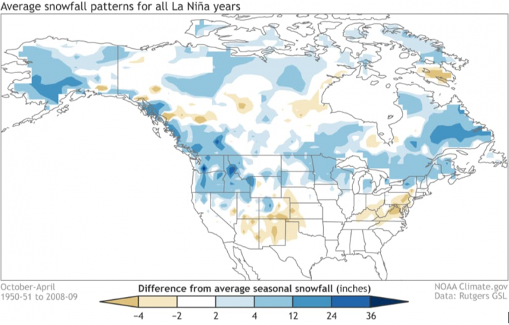
Just as is the case when putting together a winter forecast, a review of the season has to be framed by the state of the Pacific Ocean. That is, were we in the midst of an El Nino, a La Nina, or neutral conditions with respect to the water temperatures in the equatorial regions of the Pacific? The answer is La Nina, because those waters were colder than the long term normal throughout the season. In the summer and fall, I am often asked by friends where the best skiing will be in the coming season. When an El Nino is present, I always tell them to favor the central and southern resorts if they are headed west. Conversely, if it is going to be a La Nina winter, I advise that they stay north of I-70. Why? Well, here is a map of the average winter snowfall for all La Nina years.
It is clear to see that when La Nina conditions are present, the jackpot for snow is typically found in the northern Rockies and Pacific Northwest, including far western Canada. Although the correlation is weaker the farther east you go, due to the extra distance from the warm/cold pools in the Pacific, you can see that generally speaking the Upper Midwest and the northern resorts of New York and New England do pretty well. How did this season work out? Here’s the Top 10 resorts in terms of snowfall, through March 15th (the latest I could find).
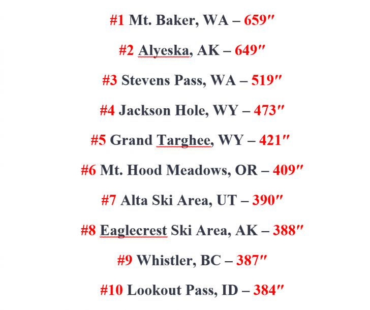
No surprise that all ten are in the West. Only occasionally does a Jay Peak or Sugarloaf push their way onto this list and after a paltry amount of snow in March, there will be no New England “contendahs” this year. Now, notice where 9 of the Top 10 are located…north of Interstate 70! Alta is the only exception, and they are only slightly south of that line of demarcation. Also, Alta’s normal snowfall is close to 550 inches, and I doubt that they will get that extra 200 inches to reach normal snowfall between mid-March and when the lifts stop turning at the top of Cottonwood Canyon. Moral of the story – if it’s a La Nina, stay north of I-70. If it’s El Nino, head to the central and southern resorts.
Elsewhere, the Upper Midwest bucked the La Nina trend with a below normal snowfall season at most resorts. In a more typical La Nina fashion when a southeastern upper ridge brings spells of warmth, the season was more of a struggle at times in the mid-Atlantic and Southeast but these regions had several runs of stellar conditions if your timing was right. The Northeast enjoyed a solid season, with a “Fabulous February,” and then the flakes stopped flying in March.
For those of you who might think on a broader scale, I leave you another way to measure how this season worked out with respect to snowfall. It’s a graph of seasonal snow extent (in square kilometers) from December 1st through February 28th, which constitutes “meteorological winter.”

This winter was better than 5 of the last 6 and 7 of the past 10 and the data trend over the past 50-plus years is positive, contrary to what some folks want you to believe. The models that focus on El Nino/La Nina are hinting that we may be in La Nina again next winter, something to consider as you start to put together your travel plans. Thank you very much for reading my column the past several months. Right now, though, “That’s a wrap!”
- The Skiing Weatherman March 24, 2023 - March 24, 2023
- The Skiing Weatherman February 24, 2023 - February 23, 2023
- The Skiing Weatherman February 10, 2023 - February 2, 2023


Alta is definitely north of Interstate 70. You must mean I-80. As of 8 AM Friday morning April 16 their website shows 471″ total, and it is snowing. This is Alta’s official last weekend, although they open for a bonus three days next weekend, then close for the season.
Jan:
Thank you for the correction. I will chalk that one up as a brain cramp. You got me thinking though, and going forward, in addition to using I-80 as the line of demarcation, I might use the area in WY, CO, and UT between 80 and 70 as a “toss up zone”, as the La Nina/El Nino correlations aren’t as strong there. Thanks for the updated Alta number…looks like they will come up short of the 550.
Regards,
Herb Stevens
Two Utah ski resorts that are south of I-70 are Eagle Point (near Beaver) and Brian Head (near Parowan).Both get quite a lot of snow, as they are at high altitudes. I did not get to either this season, since I had a bout with gout that cut my skiing short in mid January.
Herb, Thanks for your wonderful explication of our winter weather. I have learned a lot. I live in the hills south of Syracuse NY which normally receive a 120” average season total. This year was a record low, hallmarked by a total of only 1” for the entire month of March. Any ideas as to what caused the March bust much appreciated. Thanks again !
Richard: Always glad to hear from someone in central NY. My grandmother and grandfather were SU Class of ’25! March was a snow bust is most of the Northeast, although one exception was a small area north of the Thruway and east of Lake Ontario…The Tug, basically. Biggest problem in March was the lack of cold air. Most disturbances generated rain because an upper level ridge over the Southeast…a typical feature during La Nina…pushed northward and nudged the overall temperature regime upward. It also deflected the storm track northward into the St.Lawrence Valley, putting Song, Lab and Greek Peak on the warm side of the street with March storms. The Tug Hill Plateau got some snow on on the front end of those storms and after some rain, backlash helped them out, as well.
Regards,
Herb Stevens
I was going to mention that Alta is north of I-70, but Jan beat me to it. South of I-70, Wolf Creek may have had the most snow with 362″ by their closing date of April 4, though now that they are closed another storm is on the way. The only part of Colorado with near average snowfall was the southern San Juans in the general area of Wolf Creek. The rest of Colorado and all of New Mexico were below average for snowfall. And here, of course, we are hoping another La Nina does not materialize next winter.
Alyeska has many days of “mixed precip”, flat light,wind holds and terrain closures. The addition of race training limits terrain accessibility. It is run well by the new owners and every effort is made to keep “it open”.
The two main chairlifts + tram are frequently full on weekends with covid spacing requirements. The truth is its lifts’ capacity, the weather, the LIGHT makes for a operational challenge . The webcams are a blessing. Their Mountain Manager “GETS IT”. Still come prepared with low light skills,they make the sunny days better.