Tag Archive for: skiing weather forecast

seniorski1

The Year in Review

El Nino, Stay South. La Nina, Go North.

If you haven’t already done so, it’s close to the time when the skis and snowboards get tucked away for summer hibernation.  Between Covid-19 restrictions, National Forest leases, and Old Man Winter calling it quits prematurely in much of North America, forces have conspired to end the season for the majority of winter sports enthusiasts.  This is my final posting of the season, so I thought I might take a look back at the season that was.

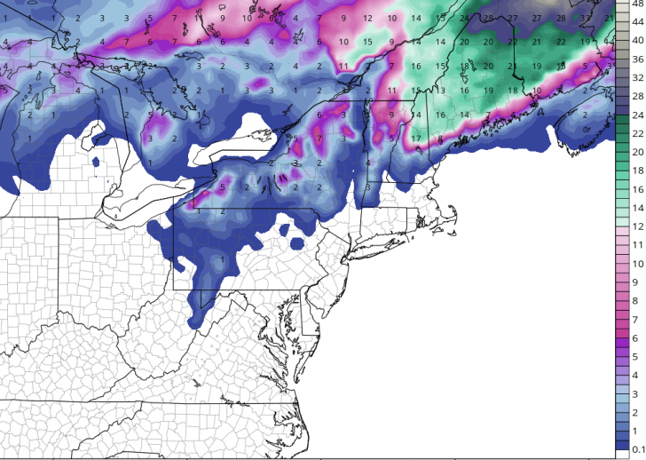
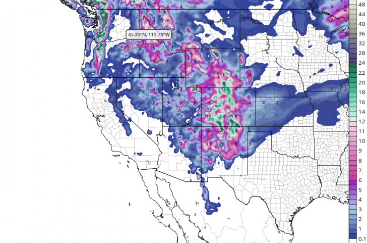
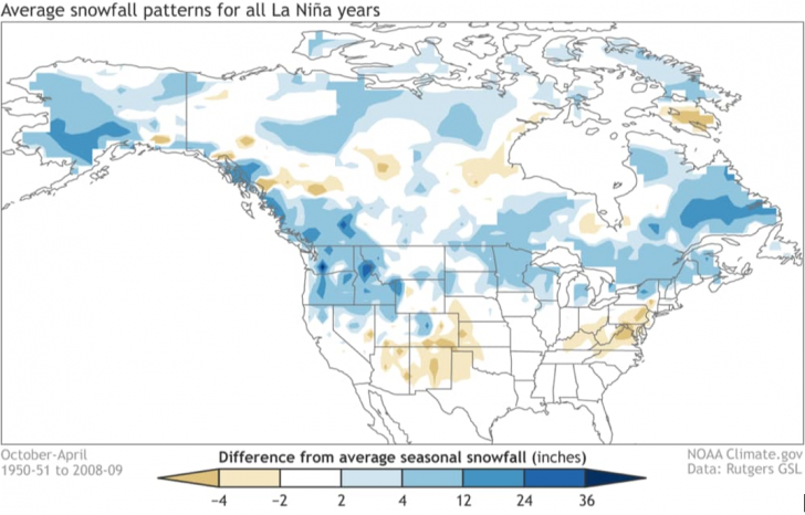
Just as is the case when putting together a winter forecast, a review of the season has to be framed by the state of the Pacific Ocean.  That is, were we in the midst of an El Nino, a La Nina, or neutral conditions with respect to the water temperatures in the equatorial regions of the Pacific?  The answer is La Nina, because those waters were colder than the long term normal throughout the season.  In the summer and fall, I am often asked by friends where the best skiing will be in the coming season.  When an El Nino is present, I always tell them to favor the central and southern resorts if they are headed west.  Conversely, if it is going to be a La Nina winter, I advise that they stay north of I-70.  Why? Well, here is a map of the average winter snowfall for all La Nina years.

It is clear to see that when La Nina conditions are present, the jackpot for snow is typically found in the northern Rockies and Pacific Northwest, including far western Canada.  Although the correlation is weaker the farther east you go, due to the extra distance from the warm/cold pools in the Pacific, you can see that generally speaking the Upper Midwest and the northern resorts of New York and New England do pretty well.  How did this season work out?  Here’s the Top 10 resorts in terms of snowfall, through March 15th (the latest I could find).

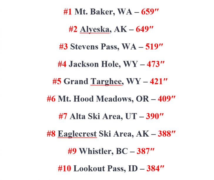
No surprise that all ten are in the West.  Only occasionally does a Jay Peak or Sugarloaf push their way onto this list and after a paltry amount of snow in March, there will be no New England “contendahs” this year.  Now, notice where 9 of the Top 10 are located…north of Interstate 70!  Alta is the only exception, and they are only slightly south of that line of demarcation.  Also, Alta’s normal snowfall is close to 550 inches, and I doubt that they will get that extra 200 inches to reach normal snowfall between mid-March and when the lifts stop turning at the top of Cottonwood Canyon.  Moral of the story – if it’s a La Nina, stay north of I-70.  If it’s El Nino, head to the central and southern resorts.

Elsewhere, the Upper Midwest bucked the La Nina trend with a below normal snowfall season at most resorts. In a more typical La Nina fashion when a southeastern upper ridge brings spells of warmth, the season was more of a struggle at times in the mid-Atlantic and Southeast but these regions had several runs of stellar conditions if your timing was right.  The Northeast enjoyed a solid season, with a “Fabulous February,” and then the flakes stopped flying in March.

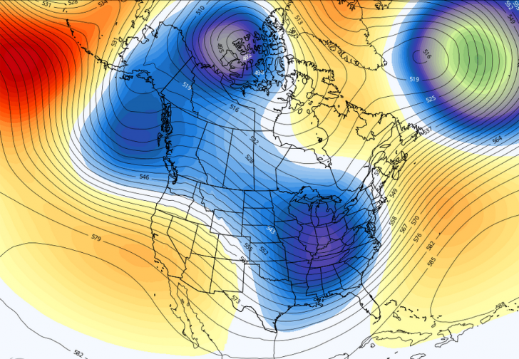
For those of you who might think on a broader scale, I leave you another way to measure how this season worked out with respect to snowfall.  It’s a graph of seasonal snow extent (in square kilometers) from December 1st through February 28th, which constitutes “meteorological winter.”

This winter was better than 5 of the last 6 and 7 of the past 10 and the data trend over the past 50-plus years is positive, contrary to what some folks want you to believe.  The models that focus on El Nino/La Nina are hinting that we may be in La Nina again next winter, something to consider as you start to put together your travel plans.  Thank you very much for reading my column the past several months.  Right now, though, “That’s a wrap!”


Skiing Weatherman: West Strong, Last Call East

Bluebird Days. Light Snow.

The weather pattern hasn’t changed much in the past week as the jet stream set-up has continued to feature a cold trough over the western half of the country and a milder to warm ridge over the eastern half.  It has been another snowy week in the West, although amounts of fresh snow have been a little less than the prior week.  In the Midwest, Southeast, and Northeast it has been a warm week, and both base snow and trail counts have taken a hit.  Changes in the pattern are underway, however, as low pressure centers that get ejected out of the western trough head northeast and mount an attack on the ridge.  The ridge is formidable though, and it won’t back down without a fight.  It will take three surface storms to knock down the ridge enough to cool the atmosphere sufficiently for snow to fall instead of rain.  That third storm will impact the Northeast later this weekend and into next week and could possible represent the final opportunity for significant snowfall, as the pattern will shift to a warmer regime right after Easter.  Here is a look at a snowfall forecast through Tuesday morning.

You’ll notice that New Hampshire and Maine look like the big winners.  That is because one low pressure center will move through Ontario as it weakens with a secondary low center taking shape over Cape Cod before it moves through the Gulf of Maine, strengthening as it does.  That track will most benefit the White Mountains and the resorts of Maine.  After picking up very little snow in the past three weeks, and with Easter weekend on the horizon, a healthy shot of snow would help sustain quality skiing and riding through the holiday.  Some light snow will accompany the passage of another trough and cold front on Good Friday and that will help refresh the surfaces, as well.

In the West, the persistent trough will produce its final shot of snow late this week (especially in CO and WY) setting the stage for a wonderful weekend with bluebird skies dominating as the trough swings out of the region and into the center of the country.  A new trough will arrive next week, however, bringing early week snow to the Northwest and midweek powder to the full length of the Rockies.  Here is a snowfall forecast through Friday for the West.

The amounts you see are pretty much split between the end of this week and the week of the 29th.

Many of the resorts in the Midwest have closed, but the larger areas are still open.  Some light snow amounts will fall across the northern Great Lakes later this weekend.  In the Southeast, about a half dozen resorts are still operating, thanks to high base elevations and aggressive snowmaking through the season.  That snow can’t hold on much longer against the strength of Old Sol, though.

REGIONAL HIGHLIGHTS:

Pac NW/B.C.:

Beautiful weekend on the slopes.  Light to moderate fresh snow early next week keeps the powder party going.

Central and Southern Sierra:

Great spring skiing this weekend. Back door cold front turns it a little colder next week, but no significant snow in sight.

Rockies:

Sunny weekend on the slopes.  New trough delivers light to moderate snow from MT to NM first half of next week. Light snow next weekend in northern resorts.

Midwest:

Light snow across the far north this weekend.  Mild start/colder finish next week with another round of light snow.

Northeast:

Spring conditions rule after mild, damp week.  Opportunity for meaningful snow late this weekend/early next week in northern NY and northern New England.  Another round of light snow late week.

Mid-Atlantic/Southeast:

Great spring skiing Saturday (3/27).  Colder air mass arrives later Sunday.  Spring skiing continues next week. Call resort before you drive, though.


Skiing Weatherman: Season Rolls On in West, New Snow Scarce in East

Fresh Snow in the Wasatch. Spring Conditions Reign East.

This week’s message is quite simple: If you want fresh snow, head west.  If you enjoy spring skiing, the upper Midwest and East will sport those conditions much of the time through the end of the month.  That said, I do expect the East to turn a little colder early in April, but the jet stream may remain benign enough to make it tough to support a storm with fresh snow for the Easter weekend.

As usual, I will point to jet stream features to explain my forecast.  The jet stream is the hand that moves the high and low pressure systems at the surface around like chess pieces.  Here is a look at the jet stream for Wednesday of next week.

The orange humps that you see in the Pacific Northwest and over the eastern third of the country are ridges, where milder than normal air is located at roughly 15,000 feet above sea level.  Ridges produce warming at the surface, as well as a lack of storminess.  The blue features that look a bit like buckets are troughs, where colder than normal air pools and supports low pressure surface storms that produce snow.  The two lobes of the western troughs will produce snow this weekend into next week from the Sierra into the southern Rockies, and it looks the resorts of the Southwest and Colorado will enjoy another solid dose of powder after the dumping of last weekend.   The Pac Northwest has been the bullseye for much of the heavy hitters this season, but that ridge you see in that region will lead to a relatively quiet week.  No worries – base depths in this part of the country, as well in adjacent Canada, are VERY healthy and can withstand a mild spell with ease.

Now, I do think that the trough will consolidate and attempt to move into the East in about 10 days, but any time a trough runs into the back end of a ridge, the trough tends to weaken in terms of circulation and cold air, and be deflected by the ridge.  Here is a look at the jet stream for Monday morning of the 29th with the ridge moving offshore and the trough trying to force its way into the East.

The trough will tend to lift out to the northeast from where it will be on the 29th, rather than bodily move toward the coast, so although we could see a late snow event around the 29th/30th, I don’t believe that it will be a major snowfall. The upper Midwest will stand a better shot at meaningful snow from this system.  As we head through that week and toward Easter weekend, I do think that it will turn cooler in the East, but at this point, I would have to rate a fresh snowfall of significance leading into the holiday a long shot.

If you want fresh snow? Go west.  Sliding in the Midwest or East?  Grab some sunscreen.

REGIONAL HIGHLIGHTS:

Pac NW/B.C.:

Snow falls this weekend into early next week.  Upper ridge develops and leads to dry spell after that.

Central and southern Sierra:

Cold air keeps snow dry this weekend; some light snow early next week with slow warming later in the week as ridge expands down the coast.

Rockies:

Light snow this weekend and again early next week central and north.  Moderate to heavy snow Wasatch and southern resorts from a multi-day storm starting this weekend.

Midwest:

A mild spell settles in this weekend, turning cooler later next week.  Turning colder late next week with improving prospects for snow.

Northeast:

New snow prior to the weekend in the Catskills and Berkshires.  Seasonable temps and dry this weekend. Spring snow conditions rule region-wide next week.

Mid-Atlantic/Southeast:

Nice spring skiing this weekend then mild next week as ridge calls the shots.  Days limited for skiing this season.


Skiing Weatherman: Pattern Quiets Down a Bit

Warmer end to February. March Snow Looks Good.

This has been an absolutely wild weather week across the country, with more heavy snow in the West, the worst run of cold and snow in the southern Plains since 1899, and two significant storms in the East, although the first one generated a fair amount of sleet earlier this week.

As I discussed last week, in the wake of this week’s arctic plunge, the pattern is changing to one with more Pacific air involved, so we are headed toward an end to February that won’t be as cold as much of the month has been.  In terms of the jet stream flow, we will continue to see troughs track across the country and those systems will present us with our shots at fresh snow.  The troughs won’t have quite as much cold air to work with, though, so snow levels could become a minor issue and rain/snow lines will work into the equation with storms in the Midwest and East in the next couple of weeks.  The historic push of arctic air actually drained a good percentage of the available cold air out of Canada.  Yes, it is still plenty cold to the north, but it will take a couple of weeks to build the deep cold that can help sustain the season with a southward push during the month of March.  Here’s a map that I haven’t shown before.  It is a forecast of the standard deviations of temperatures for the next ten days over Canada.


Notice that the values, whether positive or negative, are overwhelmingly close to neutral.  Ten days ago, most of the southern third of Canada, centered over Manitoba and Saskatchewan, had negative values of 5 and 6 standard deviations, consistent with an air mass that was 30+ degrees below normal. That is the air mass that plowed all the way down to south Texas in the past week.  Those values will be dropping in the near term, as it is still the heart of winter to the north.  The question then becomes whether that air will get involved in the pattern over the U.S. in March, when higher sun angles, rising normal temps, and longer days can start to take their toll on surface conditions and base depths.  Right now the prospect for a turn to colder weather looks promising for early March.  Not harsh cold, but a little below normal.  Again, the final week of this month will be milder over the East, while cold persists in the West, but this map of 5,000 foot temperature anomalies for March 5th shows cold air over the East and an ample supply sitting over Canada for reinforcements.  The five thousand foot level is a proxy for surface temps.


So, although the pattern will moderate for the East in the short term, it won’t last long and the prospects for March look good at this point, although a typical La Nina upper ridge could bring the southeastern season to a premature end.  

REGIONAL HIGHLIGHTS:

Pac NW/B.C.:

Snowy pattern carries on. Snow levels rise a bit early next week before settling back down.

Central and southern Sierra:

Light weekend snow, milder during the week of the 22nd.  Pattern cools down and snow opportunities return next weekend.

 Rockies:

Pacific flow brings light to moderate snow every day or two Wasatch and Tetons northward.   Northwest trajectory brings occasional light snow events central and snow is more scarce until late next week farther south.

Midwest:

A little milder than normal and with a few light snow events in the next week in MN, WI, and northern MI.  A great time to hit the slopes, very comfortable.

Northeast:

Not as cold as past few weeks. Weaker Clipper systems bring light mountain snow every few days.  Lower elevation resorts see light mixed precip with surfaces softening/moistening somewhat.

Mid-Atlantic/Southeast:

Light mountain snow 22nd, then milder.  Spring surface develops in all but the highest resorts next week.


Skiing Weatherman: The Hits Just Keep On Coming

Busy Storms. Slopes in Good Shape.

As I write this piece at the start of President’s Day weekend, the slopes from coast to coast are in fine to extraordinarily good shape, thanks to a very busy coast to coast pattern of storms that has played out in recent weeks.  A push of arctic air delivered by the stratwarm episode that was discussed in last week’s column is providing cold air over the eastern two-thirds of the country.  At the same time, upper level energy that supports the stormy pattern continues to be ejected from an upper level trough over the Aleutians.  After the holiday weekend those disturbances will continue to favor resorts north of I-70 and I-80 in the West, but as the energy tracks eastward and interacts with the cold air flowing into the center of the country from Canada, storms will bring fresh snow to the Midwest and the East.  Here is a jet stream for Friday the 19th that illustrates the snowy “handoff” pattern that is in place now and should stay in place for the next couple of weeks.

With one trough over the Gulf of Alaska and another over the eastern half of the country, combined with a blocking ridge still hanging around Greenland, storm after storm will cross the country, some small, some more significant.  Initially, the snow will fall in British Columbia and the resorts of the Pac NW and northern Rockies.  The northern Great Lakes will pick up a round of powder as the disturbance heads toward the high amplitude trough that stretches from the Great Lakes to the Gulf of Mexico.  As the disturbance in the northern branch of the jet stream interacts with the larger system, the result could be a storm that could run up the length of the Appalachians late in the week and into next weekend.  As I suggested earlier, there will be ample cold air around, as shown by this map of 5,000 foot temperatures for next Friday.

The green and gray colors show where temps will be below 32 degrees aloft, a proxy for snow vs. rain at the surface.  You can see that a long-track snow event up the eastern seaboard could indeed be in the cards.  Now if you look at the jet stream map above, you will see an extended trough reaching from the waters west of Washington northward to the Arctic region.  The counter clockwise flow around that feature suggests that after 10-12 days of domination by arctic air, Pacific air masses will get involved, leading to somewhat milder weather (less cold) by the end of the month or so.  In the meantime, enjoy the frequency of flakes and preponderance of powder!

REGIONAL HIGHLIGHTS:

Pac NW/B.C.:

Big storm late this week followed by more storms from the Gulf of Alaska rolling into the mountains of B.C., Washington, and Oregon.

Central and southern Sierra:

One storm this weekend and another early next week.  Glancing blows from storms to the north bring light snow later next week.  Heavy snow next weekend.

Rockies:

Weekend snow followed by a moderate to heavy accumulation a couple of days later central and south.  Potential for another round next weekend.  Moderate amounts of snow next week in northern resorts

Midwest:

Arctic air dominates.  Light snow from Clipper systems and some lake effect snow in northern Lakes.

Northeast:

Parade of storms continues to add snow every couple of days.  Shot at significant snow middle of next week and again late in the week.

Mid-Atlantic/Southeast:

Two shots at moderate to heavy snow in next week…first one around Tuesday and again a couple of days later.


Skiing Weatherman: Ch-Ch-Ch-Changes

For the title of this piece I chose a line from David Bowie’s classic song. The jet stream pattern that ultimately determines the snowfall haves and the have-nots is undergoing change and, ultimately, it will be dramatic.

As a lifelong skier and weather nerd, my step gets a little lighter and I tend to have a song in my mind when the weather pattern is soon to become more favorable for cold and snow.  I’m an Easterner and guilty of a provincial bias. So far, the East is at the short end of the weather stick. Other regions (i.e. Southwest, Wasatch, and Tahoe) also are struggling to attract snow. But much of the East remains significantly below typical trail counts for early January, largely due to the massive Christmas rainstorm.  

In my last report, filed a week before Christmas, it looked like the holiday storm could be a major snow producer.  Alas, there wasn’t enough cold air available to make that happen, and that has been the case much of the time since.  Pacific air has been flowing across the country, leading to heavy snow in the Pacific Northwest, with lighter, but still significant amounts across the northern Rockies.  Further downstream, plenty of disturbances have tracked through the Midwest and East, but without cold air from Canada, those disturbances have produced mixed precip events. 

So, what is going to change?  It’s the jet stream, the hand that moves the pieces on the weather chess board.  Here is picture of the current set up… 

The red blob over northeastern Canada is a blocking ridge slowly migrating west.  It will end up over far northwestern Canada by mid-month, where it will tap a growing supply of cold air.  The blue area over the Southeast is a trough that is delivering a late week snowfall to the southern Appalachians.  That storm is suppressed by the ridge to the north and until it the ridge moves northwestward, it will be tough for any storm to turn the corner into the Northeast.  But I do think that will happen within the next week, and likely several times in the following weeks.  Also of note, if you look over the eastern Pacific and follow the lines from west to east, you can see that the prime source of air masses is the Pacific, not the Arctic.  

Now take a look at a jet stream forecast for the 18th, one that I agree with.


The changes are substantial.  The ridge is stretched out across the far northern latitudes, with an extension over the northeast Pacific.  The clockwise circulation around the ridge will help access cold in the Yukon.  A deep trough over eastern North America is poised to receive the cold and spawn surface storms.  

Better times are ahead for skiers and boarders east of the Mississippi.  At the same time, rather quiet weather will develop out West.  This pattern, once established, will persist into February.                  

Regional details…         

Northwest U.S./Western Canada:  Occasional Pacific systems will bring snow next week…slowing down after,  as western ridge builds.  

Sierra:  Storm track to the north for the foreseeable future.  

Rockies:  Moderate snow events across the north in the next week…weaker systems fight through the ridge after that.  Central and southern Rockies pick up occasional light snowfalls.       

Midwest:  Cold starts pushing late next week, Alberta Clippers and lake effect snows will become frequent events for the second half of the month…and beyond.

Mid Atlantic/Southeast:   Fresh snow in NC mountains late this week.  Entire region in line for mountain snows and great snowmaking as the cold air deepens after mid-month.     

Northeast/QB:  Cold, but with suppressed storm track through next week.  Extended cold, snowy pattern develops thereafter.