
The Skiing Weatherman November 25, 2022
By the time you read this you may have already made your first turns in the new season. Mother Nature has been generous with cold and natural snow from coast to coast, with the West favored in late October and early November and then the Midwest and East over the past couple of weeks. The East is where I am going to focus my reports this season. It makes sense because I have skied at most every resort east of the Appalachians over the years and the vast majority of my forecast clients are in that same area.
It might surprise you to know that the FIRST resort to open in the East this year was Sugar Mountain, NC. When early season cold is short supply, elevation matters, and Sugar’s base is right around 4,000 feet. Since they started turning lifts mid-month, several dozen resorts have joined in the fun, and many of them are already sporting double digit trail counts with multiple top to bottom routes open. Everything is set up for one of the busiest Thanksgiving weekends in many years, but there is just one problem…the weather.
The early season cold outbreak from Canada has just about run its course, and for the next ten days or so…through roughly 12/6…any cold air masses that move through the East will be transient, and generally confined to the resorts of NY and New England. As Black Friday gets underway, a weakening low pressure system and cool front are moving across the spine of the Appalachians and the passage of that system will lead to a round of light rain. Saturday will be the best day of the weekend to get out on the slopes, but another low will cut up through the eastern Great Lakes and then cross central New England Sunday and Sunday night. There won’t be cold air around to support snow, so Sunday looks wet…not the greatest news for Day 2 of the Women’s World Cup at Killington.
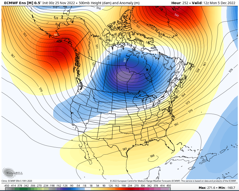
Temperatures will be quite variable over the next ten days as relatively weak disturbances track into the Lakes and then run along the U.S. Canadian border…an unfavorable track for snow and cold except for northern Ontario and northern Quebec. Snowmaking windows will be small, but there will be several along the way. The pattern will change at the end of the first week of December, though. Why? Well, first there is the EPO, or Eastern Pacific Oscillation. The EPO is an index based on the relative positions of upper level ridges and troughs over the northern Pacific Ocean. When it is negative, we find a ridge over Alaska and British Columbia and a trough downstream over central North America. The clockwise flow around the ridge directs very cold air from the high latitudes southeastward into the counter-clockwise circulation around the trough, leading to an intrusion of very cold air into the lower 48. Even if the main thrust of the cold is into the center of the country, it will spread out and reach the east coast. Here is the forecast for the EPO over the next two weeks…
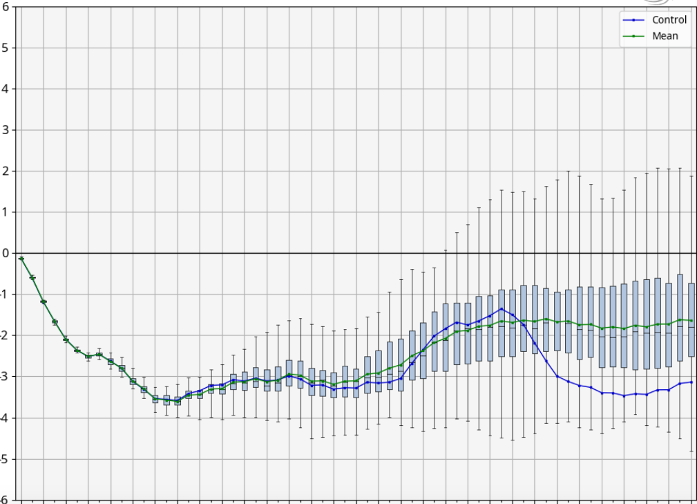
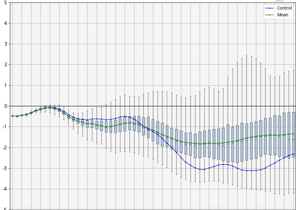
The correlation between a negative EPO and cold in the East is a strong one and you can see that the EPO is consistently negative, suggesting a change in the temperature regime. Supporting that idea is the outlook for the NAO, another ingredient of the “alphabet soup” of indices that I use to sort out winter pattern changes. The North Atlantic Oscillation is built on the pressure differential between Greenland and the Azores. When pressures are high over Greenland, the jet stream pattern gets blocked up, often with an upper trough setting up shop over the Northeast, where it can draw cold air south from Canada. Here is the two-week forecast for the NAO…
If we take a quick look at the jet stream setup anticipated for 10 days from now, you can see that the pieces are in place for a return to colder weather…the ridges over Alaska and Greenland, with a trough over central Canada poised to deliver a fresh cold air mass to the eastern U.S. as it tracks southeastward.
The season is off to a fast start, but trail count expansion will pause before picking up the pace again about ten days from now.
- The Skiing Weatherman March 24, 2023 - March 24, 2023
- The Skiing Weatherman February 24, 2023 - February 23, 2023
- The Skiing Weatherman February 10, 2023 - February 2, 2023

How about continuing to report for the West also. Many of us living in the East make trips out West several times a winter and your excellent forecasting helps a lot with planning. thanks
Great Report Herb, we look forward to the colder air at Laurel Mountain, Hidden Valley and7 Springs.
I’m a regular reader of your reports and look forward to them! Glad to see you back reporting this year!
Good stuff Herb. As usual. Edges and bindings all tweeked and ready to go. Let’s coordinate at some point.
Michael: Due to work obligations, I will only be able to focus on the East this winter. I will include a brief discussion of the Midwest and West in my future postings, but won’t be able to provide the details that I have in the past. When you get set to go west, send in a question and I promise that I will try and answer your inquiry. I will say that in a La Nina year, as this will be, it is generally advisable to stay north of I-70/I-80.
Regards,
Herb S