Tag Archive for: La Nina

La Nina Is Here

She Is Bringing Snow For Some. Find Out Who.

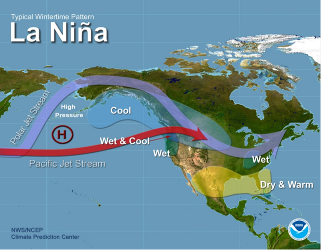
La Nina is has been lurking around the west coast of South America since August. That frosty little senorita brings cooler temperatures to the mid- and eastern Pacific waters which in turn impacts atmospheric circulation, which affects the shape of the Jet Stream across North America.  And that determines precipitation and temperatures across the entire continent, essentially shaping the severity of winter storms.

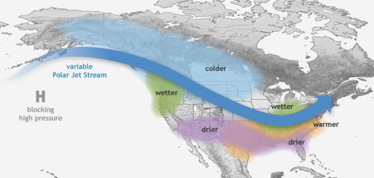
The Jet Stream is impacted by La Nina. Credit: Climate Prediction Center

The National Weather Service’s Climate Prediction Center foresees that the La Nina will hang around for the entire ski season into Spring 2021.

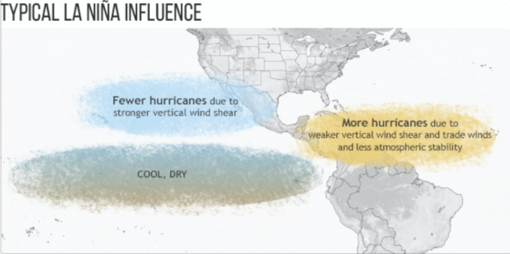
La Nina raises the potential for more hurricanes, which we are currently experiencing. As of this writing, we’re up to 28 named storms since the start of the hurricane season.

Classic La Nina weather patterns feature a wave-like jet stream flow across North America, which causes colder and stormier than average conditions across the northern tier and warmer and less stormier conditions across the south.  

That’s good snow news for Alaska, western Canada and the northern Rockies, northern California, Wyoming, and the Northwest. It’s probably drier and warmer for New Mexico, Arizona, and Southern California.  Utah and Colorado, and the Northeast as well as parts of the Midwest are in the uncertain zone. 

For an interesting discussion of the different impacts of El Nino and La Nina conditions, click here for seasonal correlations for resorts from Australia to South and North America.

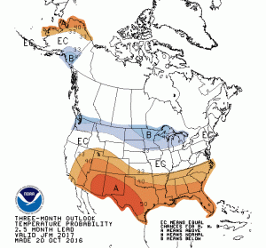
Secret formula at The Farmer’s Almanac has different outcomes. Credit: Farmer’s Almanac

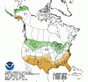
Compare the Climate Predication Center’s forecast with the 2020-21 prediction from the Farmer’s Almanac.  The venerable publication uses its own formula and data for weather prediction, and, as you can see, this year’s future picture is different than what we are hearing from NOAA.

Take your pick.

2016-17 Winter Forecast Outcome

How Close Were NOAA Predictions? The Surprise Was California.

Temperature: Forecast vs Actual, 2016-17
Credit: NOAA

NOAA’s Climate Prediction Center recently published a review of its forecast for the 2016-17 winter.  As you know from horse racing, the stock market and Las Vegas, predictions often do not reflect realities.  The question really is how close to reality the predictions are.

In October, 2016, the Winter Weather prediction was focused on factoring in a weak La Nina pattern in the Pacific.  La Nina and sibling El Nino, as you may be aware, are warm or cool water conditions roughly in the latitude of Peru in the eastern ocean.  These conditions impact the air masses above them and, subsequently, the jet stream which steers weather patterns in the atmosphere.

Climate Prediction Center thought a La Nina (cooler water) would bring generally warmer temps across the lower US and cooler in the Pacific Northwest, Upper Midwest and Ontario. For precipitation, the prediction was below normal precip across the southern US, continuing the drought situation there, and above average precip in the upper band across the US-Canada border.

In reality, the La Nina was weaker and faded away earlier than predicted. That factor plus multiple “Atmospheric River Events” off the California coast, narrow regions of heavy moisture transported from the tropics, and general randomness brought different outcomes.

Temperatures across the US in the 2016-17 winter were the warmest ever recorded. That was in line with the prediction for warmer temps across the whole country. But it was colder than average in the Pacific North West rather than the Northern Plains.  And, while precipitation for wetter than average in the Northern Tier was spot on, the forecast for drier than average only worked out for Florida, where drought conditions persist.

As we know, it was wetter than average in California with ongoing storms racing up from the Pacific. Not predicted.

In general, Climate Prediction Center’s own objective evaluation of its predictions show it was much more accurate for the temperatures this year than precipitation.

We will be bring you predictions for the 2017-18 Winter when they emerge.

Precipitation: Forecast vs Actual 2016-17
Credit: NOAA


What New La Nina May Bring To Snow Forecast

The Latest Update Shows Impact Might Good for Some, Uncertain For Others.

La Nina impact how the jet stream bends over the Pacific. Here's NOAA's prediction as of end of Oct. Credit: NOAA NWS

La Nina impact how the jet stream bends over the Pacific. Here’s NOAA’s prediction as of end of Oct.
Credit: NOAA NWS

NOAA’s National Climate Predication Center announced that La Nina has returned. She’s weak but still might pack a sting for our winter weather.

La Nina means cooling of water in the eastern Pacific.  As remote as that may seem to North America, that coolness effects how weather masses form and move around the globe.  As we reported earlier, the Climate Prediction Center said that La Nina hadn’t developed as expected after a record El Nino (warming water) in 2015-16.  But just last month, a weak La Nina was detected.

What does that mean for snow forecast? Weather forecasting is about probabilities. A look at the temperature map below (right) reveals that temps are expected to be generally warmer across the lower US and cooler in the Pacific Northwest, Upper Midwest and Ontario.  The precipitation map says below normal precip across the southern US, continuing the drought situation there, and above average precip in the upper band across the US-Canada border.  This is pretty consistent with the snow forecast we reported on last month.  Confirming an La Nina just ups the odds.

So, good news for the Pacific NW and BC, Montana, Wyoming.  Uncertainty for just about everyone else.

Remember, these are probabilities and not definitive.  Variance will happen.  NOAA will update their forecast in a few days.  We’ll let you know.

off03_prcp

off03_temp


Winter Wx Forecast: La Nina In Charge

What Will This Winter’s La Nina Bring To Snow Country?

In a La Nina year, the jet stream typically gets bent south, bringing cold air to southern Canada/nothern US. Credit: NOAA/NWS

In a La Nina year, the polar jet stream typically gets bent south, bringing cold air to southern Canada/northern US.
Credit: NOAA/NWS

El Nino, the inflow of warm water in the east/central tropical Pacific, has faded away.  The El Nino event which started in March 2015 and lasted until early 2016 was one of the warmest in the past 30 years.  You know the result: Lots of snow in the West, not so much in the East.

This year, the National Weather Service’s Climate Prediction Center is reporting those warm waters off Peru have cooled off.  In fact, the June surface water temperature is even cooler than they were in May this year. So, in El Nino’s place comes La Nina.  She can cause as much mischief with the weather as her brother.

Briefly, La Nina causes the polar jet stream to move southward, bringing colder temperatures than normal to the northern US and most of Canada. On the other hand, temps are typically warmer in the Southwest and southern plains. As for precipitation, La Nina usually brings wet weather to the upper US and Canada and drier weather in a band that goes across the southern half of the US.

Ergo, cold temperatures plus wet weather equal more potential snow in the northern band (including New England, Hallelujah!) and not so much in the southern half.

Remember, this is a prediction and not a forecast.  Don’t book your vacation plans yet.

Stay tuned, we will be watching winter predictions as they develop.

This Week In SeniorsSkiing.com (May 20)

Spring Survey Responses A Wow, Fling Golf, La Nina Coming Soon, More Cycling Series.

La Nina is next year's weather maker. Here's what happens in a typical La Nina year. Credit: NOAA

La Nina is next year’s weather maker. Here’s what happens in a typical La Nina year.
Credit: NOAA

We are truly awed and grateful for the incredible, enthusiastic responses we’ve been getting to our Spring Subscriber Survey 2016. If you’re familiar at all with surveys, you know that response rates are often in the single digits. So far, we’ve received fantastic 27.5% response rate. To us, that means our readers (you) are engaged and interested in what we are trying to accomplish. Thank you so very much. We will report results after we dig into the data.

Our stories this week venture into the world of golf, well, sort of. Fling Golf is a new take on the old game. Check out the video in the story. Flinging is really different. Will golfers like it?

We’ve been watching the weather lately as the spring and summer months are when winter patterns start to emerge. Right now, the El Nino we’ve seen create unusual snow amounts both east and west is fading away. In its place comes La Nina, cooler sea surface temperatures in the Eastern Pacific. This change will definitely play a role in next season’s snow predictions. Check out the story and resources for further study.

Our Northwest correspondent John Nelson has sent a really neat article for the Cycling Series about Arches National Park in Utah. We have learned from our survey that many of you cycle in the non-snow season and Moab, UT, home base for Arches, is a center of activity. Some amazing pictures, too, from John.

Next Week

We will be updating you on the attempt to eliminate free skiing for seniors at Cannon Mountain, NH. We’ve heard that there has been resistance to making that change. We’ll see.

We will also continue our Cycling Series as well as the usual fun stuff.

Finally, we plan to give you a first peek from the highlights of the survey. A quick glance shows there are so many wonderful ideas we can use. Once again thank you so very much for your terrific response.

And remember, there are more of us every day, and we aren’t going away.

Tower of Babel watches over Arches National Park, UT. Credit: John Nelson

Tower of Babel watches over Arches National Park, UT.
Credit: John Nelson

Adios, El Nino, Hola, La Nina

Big Changes Are Coming Again To Next Season’s Weather.

View post on imgur.com

The image above shows how the sea surface temperature is changing from warm to cooler, signaling the advent of a La Nina event.

Weather scientists are predicting that the sea surface temperatures in the Eastern Pacific will continue to drop, ending the extraordinary, record-breaking El Nino conditions that drove so much of last winter’s weather. When the sea surface water temps drop below .5 degrees C off the coast of Peru, the new La Nina will be in the wings, bringing yet another set of changes to next ski season’s weather. Some reports predict this La Nina can be as dramatically cold as the fading El Nino was warm.

During the summer coming up, the first impact you’ll see will be more hurricanes in the Atlantic. The hurricane season in the Atlantic starts on June 1 and goes to November 30. The prediction is for more storms because of weaker upper level winds.

For the winter months, a typical La Nina pattern will be cool weather in the Northwest, warm and dry across the southern border, and a wet East.  Click here for an interesting discussion from the Weather Network. 

Fun Fact: La Ninas last longer than El Ninos.  The La Nina event that followed the the 1997/98 El Nino lasted 33 months!

Here’s a more technical discussion from NOAA. 

Stay tuned for more updates as we watch how La Nina takes shape and how it will impact next winter’s weather.

The first La Nina impact could be more frequent Atlantic hurricanes. This year's La Nina is predicted to be as cool as last year's record-breaker El Nino was warm. Credit: NOAA

The first La Nina impact could be more frequent Atlantic hurricanes. This year’s La Nina is predicted to be as cool as last year’s record-breaker El Nino was warm.
Credit: NOAA