Tag Archive for: next week weather forecast

Skiing Weatherman: The Hits Just Keep On Coming

Busy Storms. Slopes in Good Shape.

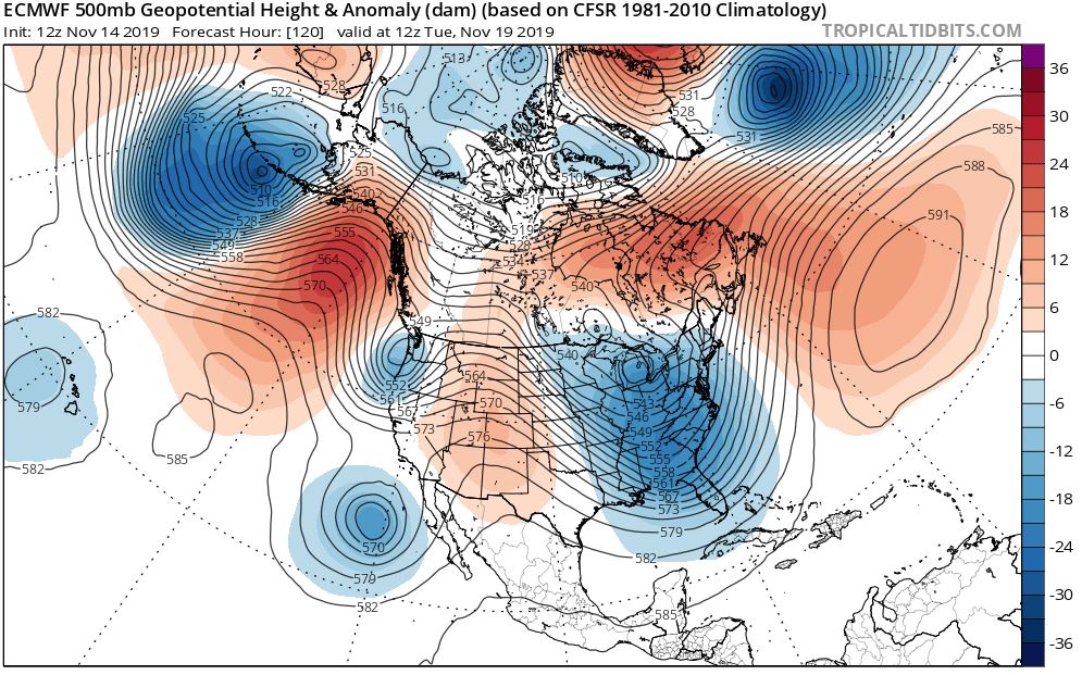
As I write this piece at the start of President’s Day weekend, the slopes from coast to coast are in fine to extraordinarily good shape, thanks to a very busy coast to coast pattern of storms that has played out in recent weeks.  A push of arctic air delivered by the stratwarm episode that was discussed in last week’s column is providing cold air over the eastern two-thirds of the country.  At the same time, upper level energy that supports the stormy pattern continues to be ejected from an upper level trough over the Aleutians.  After the holiday weekend those disturbances will continue to favor resorts north of I-70 and I-80 in the West, but as the energy tracks eastward and interacts with the cold air flowing into the center of the country from Canada, storms will bring fresh snow to the Midwest and the East.  Here is a jet stream for Friday the 19th that illustrates the snowy “handoff” pattern that is in place now and should stay in place for the next couple of weeks.

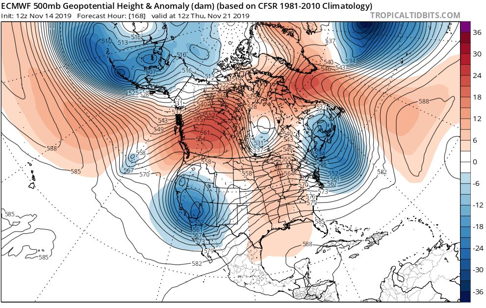
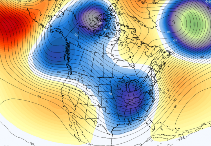
With one trough over the Gulf of Alaska and another over the eastern half of the country, combined with a blocking ridge still hanging around Greenland, storm after storm will cross the country, some small, some more significant.  Initially, the snow will fall in British Columbia and the resorts of the Pac NW and northern Rockies.  The northern Great Lakes will pick up a round of powder as the disturbance heads toward the high amplitude trough that stretches from the Great Lakes to the Gulf of Mexico.  As the disturbance in the northern branch of the jet stream interacts with the larger system, the result could be a storm that could run up the length of the Appalachians late in the week and into next weekend.  As I suggested earlier, there will be ample cold air around, as shown by this map of 5,000 foot temperatures for next Friday.

The green and gray colors show where temps will be below 32 degrees aloft, a proxy for snow vs. rain at the surface.  You can see that a long-track snow event up the eastern seaboard could indeed be in the cards.  Now if you look at the jet stream map above, you will see an extended trough reaching from the waters west of Washington northward to the Arctic region.  The counter clockwise flow around that feature suggests that after 10-12 days of domination by arctic air, Pacific air masses will get involved, leading to somewhat milder weather (less cold) by the end of the month or so.  In the meantime, enjoy the frequency of flakes and preponderance of powder!

REGIONAL HIGHLIGHTS:

Pac NW/B.C.:

Big storm late this week followed by more storms from the Gulf of Alaska rolling into the mountains of B.C., Washington, and Oregon.

Central and southern Sierra:

One storm this weekend and another early next week.  Glancing blows from storms to the north bring light snow later next week.  Heavy snow next weekend.

Rockies:

Weekend snow followed by a moderate to heavy accumulation a couple of days later central and south.  Potential for another round next weekend.  Moderate amounts of snow next week in northern resorts

Midwest:

Arctic air dominates.  Light snow from Clipper systems and some lake effect snow in northern Lakes.

Northeast:

Parade of storms continues to add snow every couple of days.  Shot at significant snow middle of next week and again late in the week.

Mid-Atlantic/Southeast:

Two shots at moderate to heavy snow in next week…first one around Tuesday and again a couple of days later.


Skiing Weatherman: Good News Goes West

Jet Stream Changes Bring In the Chills.

Last week I wrote about the “haves and have nots” in terms of favorable early season winter weather.  The East was very cold with occasional snow while the West was warm and dry.  For the most part, that is still the case, as the eastern Great Lakes and Northeast are in line for a reinforcing shot of arctic air this weekend.  Temperatures will be suitable for significant snowmaking Saturday and Sunday. About a half dozen resorts are open in the Northeast, and several more are planning on turning lifts for the first time on Saturday. 

The Great Lakes region has had the most consistently cold weather the past couple of weeks. At least a couple of Michigan resorts, Crystal Mountain and Boyne Highlands, will be in operation. 

The push of arctic air will be the last for a while, due to some changes in the jet stream configuration over the continent later next week, over the western U.S. in particular.  It’s not necessarily bad news in the East, but it certainly is good news for the West.  Here is a jet stream forecast map for next Tuesday that helps illustrates the change.

While a deep trough covers the eastern half of the country. I will get to that feature shortly. Notice a shorter wavelength trough along the Washington/Oregon coast.   That system will bring snow to the mountains of Alberta and British Columbia, but it looks as though snow levels will be very high in the Cascades of Oregon and Washington.  Remember, the waters of the northeast Pacific are quite a bit warmer than normal. That will help the eastern half of the country as we work through winter, but that warm water will tend to elevate snow levels in the Northwest.  Now, the other trough along the west coast—west of Baja—will play a role in snow production later next week as the northern and southern branch jet stream features consolidate into a larger trough by next Thursday. Take a look.

The more organized trough will have both the strength and the moisture to bring a meaningful snowfall to the mountains of the Southwest and the southern and perhaps central Rockies late next week into next weekend. 

This map also shows us the subtle changes that will cause the extreme November cold that we have seen in the Lakes and Northeast to back down somewhat as we head toward Thanksgiving.  If you recall, last week’s discussion made note of the direct discharge of arctic air from the high latitudes, the product of the combined circulation around a Gulf of Alaska ridge and an eastern trough.  That couplet combined for a straight shot from the arctic to the mid latitudes.  Look at that flow now on the second map.  Start in New York and head west along one of the lines.  You will see several changes in direction and eventually you will end up over those temperate waters of the northeast Pacific.  Yes, there is still some very cold air involved in the pattern, but Pacific air is blended in, cutting back on the intensity of the cold.

Fear not. The pattern is not going to turn noticeably warmer over the eastern half of the country, but it will turn “less cold”.  Temps will still be favorable for nighttime snowmaking, and a storm that works its way up the coast on Tuesday/Wednesday will likely produce some snow in the mountains of New York and northern New England.  Meanwhile, after a mild start to November, parts of the West will see some bonafide winter weather in the next week.