Tag Archive for: Snow forecasts

Skiing Weatherman: Fast Movers

In last week’s first installment of my weekly discussion, the Pac Northwest and northern Rockies were enjoying a parade of early season snow events while skiers and riders in the Midwest and East had to be content with tuning gear and digesting the state-by-state Covid restrictions rolling out recently.

The storms have continued to hit the same general areas that were hit in the West recently, and dozens of resorts with scheduled openings between this weekend and early December could probably open now on plenty of terrain with the snow they have picked up already. By the way, those same regions are in line for more snow in the next week!

In the Midwest and East, a fast moving trough passed through earlier this week, and the air was cold enough for snowmakers from the upper Midwest into the Northeast to get started building bases. In a transient jet stream pattern like the one we are in right now, where troughs and ridges keep marching around the northern hemisphere, making snow in these areas is a gamble.

Resorts would love to open in time for Thanksgiving, but at this time of year, seldom is there enough cold air around to keep it cold enough for snowmaking for more than a couple of days. Only if a blocking pattern develops, when an upper level ridge parks near Greenland, which then allows a cold trough to come to a halt over eastern North America, do we see appreciable early season snow or extended snowmaking windows. Blocking is not in place, so cold shots will only come along every three or four days. Luckily, when it does turn milder, the short days and low sun angle will help limit the melting of the snow that falls or is made.

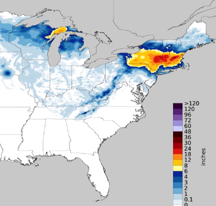
A modest cool shot will produce a minor amount of snow and enable a minor shot of snowmaking across the northern Great Lakes, Adirondacks, and northern New England later this weekend. The snow will be confined to higher elevations in the East. The next shot at cold and perhaps snow will come just prior to Thanksgiving Day, when another trough will move through the Midwest and Northeast. Right now it looks promising for snow in the northern Lakes, but in the Northeast, the best we can hope for is backside snow after rain on the front end of that event. So for now, any skiing/riding over Thanksgiving in the East looks very limited, prospects in the upper Midwest look a little better. Your best bet? In the Pac NW and northern Rockies. Here is a snowfall forecast for the next ten days that says it all.

Here are the regional details…

Northwest U.S./Western Canada: Strong troughs from the Gulf of Alaska continue to pinwheel into this region, leading to snow events every few days. Cascades and coastal ranges of B.C. will be the big winners.     

Sierra: After a productive storm midweek, this region will be south of the action for the next week as the northern branch of the jet stream dominates.

Rockies: Northern Rockies pick up a couple of additional rounds of snow early to midweek. Resort opening prospects in ID, MT, and WY look positive near-term.

Midwest: Northern resorts in MN, WI, and MI will have nighttime snowmaking opportunities through this weekend, along with some natural snow. Fast moving trough will bring light to perhaps moderate snow Tuesday/Wednesday of next week. Some limited Thanksgiving weekend skiing/riding is possible.

Northeast/QB: After two nights of snowmaking this week, another nighttime opportunity will be present Saturday and Monday nights. Two messy events could “net” higher elevation snow late weekend and Wednesday into Thursday. Lower elevation resorts on hold, waiting for cold.

Skiing Weatherman: Regional Outlooks

By the time this piece is posted, I will have enjoyed my first turns of this season, at Jiminy Peak in the Berkshires.  The skiing should be superb after more than two feet of new snow from the early week storm.  It was a slow mover and got stretched out from west to east due to a blocking pattern to the north, and the axis of the heaviest snow shows that dramatically…take a look. 

It was a major shot in the arm from the Catskills and upstate New York eastward through Massachusetts as well as in southern VT and NH, but further north in New York and New England, amounts were much lighter. 

The Midwest has benefitted from a parade of Alberta Clipper systems and some lake effect snow in the past two weeks, and trail counts have been slowly climbing in the center of the country.  The West benefitted from a series of storms in late November that hit the southern Sierra and southern and central Rockies, (Five+ FEET at Mammoth and Alta).  We all know that it takes more than one healthy storm to get things really rolling in that part of the country but recent storms have certainly helped.  The Cascades and northern Rockies have been in a quiet pattern for the most part, due to the influence of an upper level ridge that has been persistent over the western edge of the continent from Oregon northward to Alaska.  That jet stream ridge will likely be dominant this winter, due to the large pool of anomalously warm water that is present in the northeast Pacific, as we have discussed in a previous post.

So, with less than three weeks to the holiday period, every winter sports region in the country could use fresh snow, or at least consistent cold and dry weather for snowmaking.  Here are the prospects for the next couple of weeks, broken down by region.

Northwest U.S./Western Canada:  Recent snows have helped in the coastal ranges of B.C. with interior B.C. and Alberta getting some help, too.  However, the ridge looks like the dominant player the next couple of weeks but systems that weaken as they approach the coast should produce some light to moderate snow on at least a couple of occasions.

Cascades and Sierra:   A weekend storm will produce one to three feet in the Sierra, with the storm bypassing Oregon and Washington, where the ridge will hang tough.  The southern extent of heavy snow should reach Mammoth, but taper off quickly further south.  Any system that reaches the southern ranges next week will not be nearly as dynamic.

Rockies:  The northern Rockies will see some light to moderate snow at times, but no major storms, as the ridge will knock down the strength of any systems that fight their way inland after most of the moisture is wrung out by the coastal ranges.  A new, deep trough will take shape over the eastern half of the country next week and disturbances sliding down the western edge of the trough could produce some snow in WY and CO.  The southern Rockies will have to wait for another batch of southern stream systems but overall, the southern branch does not look too busy going forward.

Midwest:  After a mild, wet start to next week, this region will see a more favorable pattern develop.  A new, cold trough will take shape and deliver arctic air by midweek.  That air mass will set off widespread lake effect snow, Alberta Clipper systems will cut across the Lakes in the days to follow, and temps will be conducive to very productive snowmaking much of the time in the next two weeks.

Northeast:   Pretty much the same as the Midwest, with a one day delay for the arctic air.  Snowmaking, snow showers, and grooming will rehab the surfaces by next weekend and cold and occasionally snowy weather will dominate the next two weeks of holiday prep. 

For reasons not fully understood, the persistence of weather patterns is enhanced during times of low solar activity, especially blocking patterns.  We are very close to the bottom of the 11 year solar cycle, as shown here.

Working together with the northeast Pacific warm pool, persistence and blocking will favor the eastern half of the country this winter.