Tag Archive for: Skiing Weatherman

Skiing Weatherman: For The East, Enter Winter

A Comeback For The East And Midwest, More Pow For The West.

I spent the first two days of this week with fellow members of the North American Snowsports Journalists Association at Windham Mountain,  NY, where the crew did an outstanding job of providing a fun surface in the wake of a mid-season meltdown last Sunday. One of the presentations was by Masterfit University, an outfit that boasts having the best boot fitters in the world. It was a fascinating seminar, and after spending a couple of hours one on one with Windham’s Masterfit representative, I came away convinced that if you want to maximize your skiing, you absolutely should find a Masterfit shop in your area.

While this week started on an unseasonably mild note in the East, the skies kept unloading in parts of the West. A persistent series of low pressure centers loaded with Pacific moisture has utterly buried resorts in Washington, Oregon, northern Idaho, the Tetons, and northern Wasatch in the past week with anywhere from three to six feet of new snow. Lookout Pass in Idaho checked in with a 101 inch storm total! Lighter snows fell elsewhere in the West, and if you are heading in that direction, you can’t make a bad choice right now.

In the Midwest and East, a major pattern change is getting underway, one that delivered some fresh snow in the mountains of the Northeast late this week, with another round coming this weekend. For the first time in weeks, once the low pressure center moves through the Great Lakes and East, a bonafide cold air mass will follow in its wake, leading to great snowmaking conditions and productive lake effect snow in favored snowbelt areas, especially the upper peninsula of Michigan.

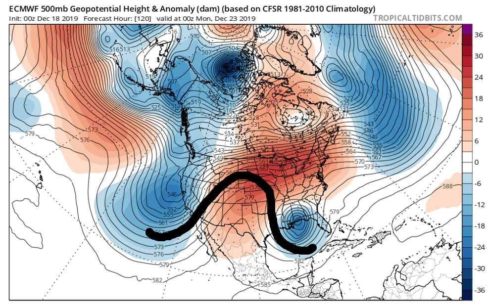
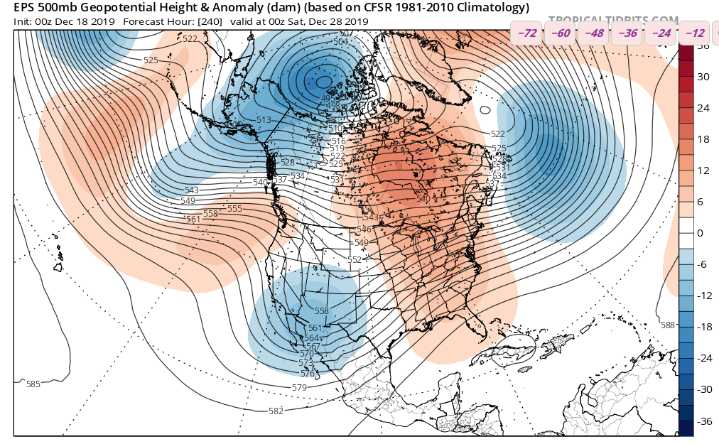
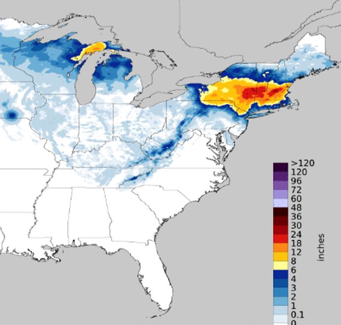
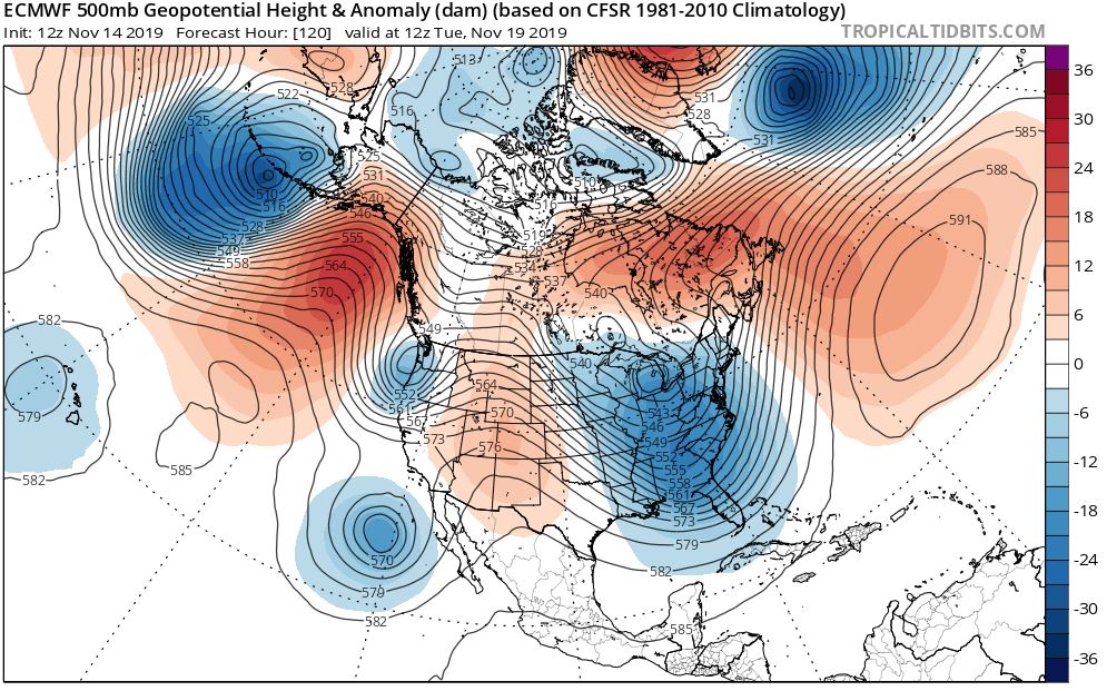
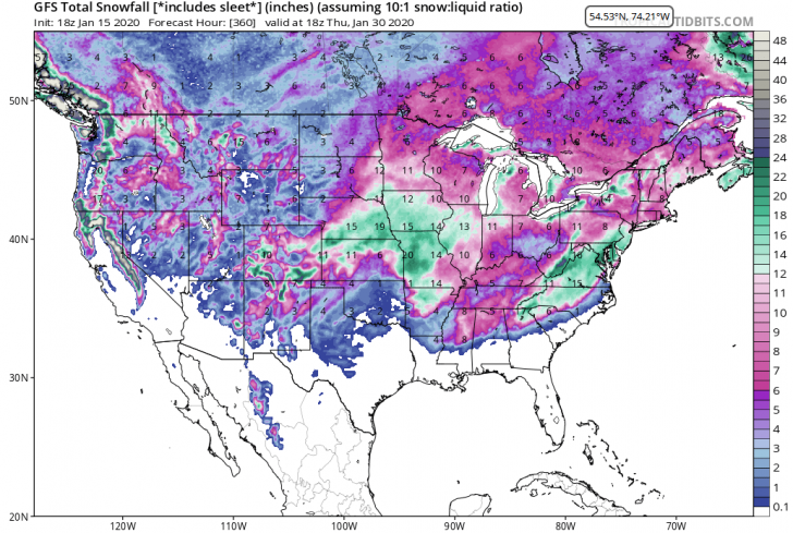
Over the next 10 to 14 days, temperatures will be stepping down over the eastern half of the country as an upper level trough becomes the dominant jet stream feature. At the same time, an upper level ridge will be found more of the time in the Northwest, so the “snow hose” that has been pointed at that region lately will back off quite a bit. The southern Sierra and southern Rockies could see periodic snows as disturbances in the southern branch of the jet move through that part of the country. If a southern branch disturbance manages to phase with energy in the eastern trough, we could see a major storm in the East before too long. The pieces will all be there soon and hopefully they will come together. For your viewing pleasure, here is a forecast map of snowfall for the next 15 days. Don’t focus on one specific spot as much as take note of the breadth of the area, particularly over the eastern half of the country, where significant snow is forecast. The pattern is rounding into shape for meaningful snow events, but the devil will be in the details.

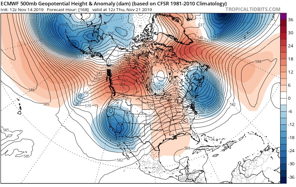
There is reason to believe that once the colder pattern gets established in the Midwest and East, it will remain in control much of the time going forward. My analog years suggest it, as does this jet stream map for two weeks from now:


The broad trough that you see for late this month looks cold and stormy to me.

Here AreThe Regional Details

Northwest U.S./Western Canada: Another rather snowy week coming up, but the recent amazing rate of snowfall will start to back down as an upper ridge takes up residence.

Cascades and Sierra:  Snowy (Cascades) into the middle of next week, although snow levels will be a little high late this weekend before settling back down. Lighter snows Tahoe area. Snowfalls back off late this month as ridging develops.

Rockies: Dry weekend into midweek when a new trough will bring some light snow. Longer term, central and southern Rockies favored for snow thanks to disturbances in the southern branch of the jet stream

Midwest: Arctic air dominates for the foreseeable future. Each frontal passage sets off lake effect snow. Great spell of snowmaking temps underway and conditionS.  Trail counts will be improving.

Northeast/QB: Moderate snow event this weekend (north of I-80) starts the comeback. Great snowmaking temps for several days in the wake of the storm. Another sizeable snow threat next weekend. Conditions and trail counts will be getting better each day until further notice.


The Skiing Weatherman: Changeable East, Snowy West and Mid-West

The West Continues To Luck Out, Cold Coming East By Month End.

Despite a wildly changeable run of weather in the East recently, I managed to get two days of wonderful winter turns in early this week. It snowed on Monday at Sugarbush as I skied packed powder with my son. Wednesday at Killington surfaces were just about perfect packed powder early on and then an arctic cold front arrived. It brought fresh snow: three inches in 30 minutes! An absolute whiteout that gave me a chance to focus on my toes with each turn, a method I was taught decades ago to deal with low visibility. It still works!

Changeable weather will continue to rule short term in the East while much of the West continues snowy, but that imbalance will be changing in the near future. The past couple of weeks, the jet stream maps across the continent have featured a trough centered over the West and a ridge over the East. The trough has produced tons of snow, particularly in the Northwest and coastal ranges of British Columbia.

As this week comes to a close, another storm will cut southeast from the Gulf of Alaska and dump on B.C. as well as the WA and OR Cascades. Lighter snows will reach down to Tahoe as well as the northern and central Rockies. Over the eastern half of the country, a low will cut northeastward through the Great Lakes and into Ontario and Quebec.  That’s great news for the resorts of Michigan, where significant snow will result. Further east, the northern track forced by the strength of the southeast ridge means another mild, wet event this weekend before colder air returns Monday. The “cutter” track is consistent with the current warm state of the MJO, as discussed last week.

Changes are coming, though, and by the final week of the month, the changes will be dramatic across the country. A pool of very cold air has been building in central and western Canada and due to the density of that air mass, it will start to spread southward and eastward. Here is a look at a forecast for the 5,000 foot temperature anomalies for ten days from now that I agree with.

The 5,000 foot level is a forecasting proxy for surface temps, and you can see that a large mass of colder than normal air will cover much of the eastern half of the country by 19th or so. Meanwhile, the West will turn a little warmer than normal, but not until after some of the arctic air descends through the Rockies later next week. At the jet stream level, the setup will flip, and we will find a trough in the East and a flat ridge out west.  Here is a reasonable jet stream forecast for the same time.

Now, any change in air masses and jet stream features of this magnitude will come with a stormy transition, so there is reason for optimism for eastern snow, at least north of the Mason Dixon line, from late next week onward. Once the new pattern settles in, I expect it to dominate through the bulk of rest of the winter, due to the anticipated influence of the warm water pool in the northeast Pacific Ocean.

Here are the regional details.

Northwest U.S./Western Canada: Another heavy snowfall is coming this weekend, light snow in AB.

Periodic lighter snows will continue next week as arctic air presses southward.

Cascades and Sierra: Snowy weekend with heavy amounts in OR, tapering down further south in CA.

Lighter snow continues next week as it turns windy and colder.

Rockies: Northern Rockies catch light snow this weekend but as several upper level short wavelength disturbances move through the first half of next week, persistent light to moderate snow will provide daily “refills”. Each successive trough will draw arctic air further south, reaching the Tetons by mid-week. Light snow in central Rockies first half of next week.

Midwest: Messy weekend storm lower Lakes, snowy in northern Lakes, narrow ice storm in the middle.

Some light snow northern Lakes from a Clipper or two next week.

Northeast/QB: Another cutter brings wet and icy weather to the northern mountains of NY/New England this weekend, snow up in Quebec. Renewed snowmaking and light Clipper snow next week, with bigger storm threat late. Pattern will look much better a week from now.


Skiing Weatherman: Global Pattern Bringing Warmth Then Cold Mid-Month

Happy New Year To All Of My Fellow Senior Sliders!

In the two weeks since my last post, the western slopes of the U.S. and Canada have been the unquestioned winners in terms of fresh snow. Just prior to Christmas, the trail counts from British Columbia south to the Sangre de Cristos of New Mexico were on the lean side, but a persistent parade of moist troughs started marching ashore from the Pacific. Those systems produced an overall snowy pattern that jacked up those trail counts dramatically. There are a few resorts here and there that got slighted by Mother Nature, but by and large, it is hard to make a bad choice out west.

While troughs produced the goods on one side of the country, flat ridging at the jet stream level have made fresh snow rather scarce in the Midwest and East. Fresh shots of cold air have been more of a glancing blow, but resorts in the northern Great Lakes eastward through the mountains of northern New York and New England have maintained their trail counts for the most part through the holiday period.

So, where are we headed from here? Well, a pattern that can best be described as changeable will unfold during the first half of January. As such, I think that there will be opportunities for resorts all across the country to enjoy some fresh snow. I still believe that we will eventually see a western ridge/eastern trough couplet become more favored, but there are too many conflicting signals coming from the Pacific for the jet stream to settle into that set up just yet.

The factor that seems to have the most impact on our weather right now is the MJO, or Madden Julian Oscillation. The MJO is all about convection that forms in the Indian Ocean and tracks eastward into the southwest Pacific. Madden and Julian divided the track into eight sectors and noticed that there were significant correlations with weather over North America, with a lag of 7-10 days, depending on where the thunderstorms were clustered.   Right now, the convection is fired up north/northwest of Australia, as you can see in this infrared satellite picture.

If you follow the green line in the chart below—each black dot is one day—you will see the MJO making a move into octants 4 and 5 in about a week. [Editor Note: octants 4 and 5 represent continental North and South America.]

Using the temperature correlation maps below, you can clearly see that octants 4 and 5 are warm over much of the country, and I believe a warmup will occur mid-month before the pattern turns colder again.

Before any warmth reaches the East, though, Midwest and Eastern resorts—north of the Mason Dixon line—will pick up fresh snow at least a couple of times. The first event will be this weekend as a storm cuts southeastward to the mid-Atlantic coast before turning up toward New England, with an Alberta Clipper sliding through the East a couple of days later. Big winners in the snow derby the next week or so in the West will be the Cascades, northern Rockies, and the resorts of B.C.

Here are the regional details.

Northwest U.S./Western Canada: Healthy storm nails B.C. this weekend, with another system arriving later next week.

Cascades and Sierra:  Light to moderate snow in the Cascades this weekend. Northern system late next week looks productive in WA/OR, but the Sierra will only receive lighter amounts.

Rockies: Late this weekend/early next week the Rockies will pick up light to moderate snow (north) and generally light amounts south of I-70. The Tetons and Wasatch are in line for moderate to heavy snow late next week.

Midwest: Early week Clipper system will deliver light to locally moderate snow, with the best snowmaking temps in a while following. That cold air will also support lake effect snow in northern parts of the lower peninsula of MI.

Northeast/QB: A system this weekend will turn into a moderate to locally heavy snow producer from WV northeast into New England and southern QB. A Clipper system will follow in the middle of next week with the potential for additional light to moderate snow.


Skiing Weatherman: All Is Calm

Except The West Coast.

Last week I discussed the role of upper level troughs as they relate to our insatiable appetite for fresh snow, both natural and machine made. Most of the time, troughs are indeed our friends but that doesn’t necessarily mean that upper level ridges are the enemy. The influence of ridge is just like the old cliche about real estate: location, location, location. Troughs often look like the letter “U” on a map while ridges tend to take on the shape of the Greek letter Omega. I have used a jet stream forecast map for Sunday the 22nd to illustrate this common configuration.

Now, in order to take on the Omega shape, you can see that the two ends of the line are wrapped around adjacent troughs, and that is where the location piece comes into the equation. You see, ridges are areas where overall, the air is sinking. Sinking air limits cloud cover and precip, and it also warms up as it sinks, consistent with the laws of physics. So, if you find your favorite resort under a ridge, your odds of seeing snow are greatly reduced. But, if that same ridge is off to the west of the resort by several hundred miles or more, the clockwise flow around the ridge will work together with the counterclockwise flow around a downstream trough to the east to tap cold air from the north. At that point, the ridge becomes your ally. As I have expressed in earlier posts, I am confident that a western ridge/eastern trough couplet is going to be the favored setup as we head through this winter, but in the shorter run, the ridge is going to spread out and cover much of the eastern two thirds of the country as we head through the holidays. Overall, Pacific systems will bring seasonable cold and some snow to the west while it is milder than normal east of the Mississippi.

Here Are The Regional Details.      

Northwest U.S./Western Canada: A very juicy storm will be in progress into this weekend. Whistler finally gets tagged. Cascades get healthier trail counts. Pattern more benign next week.

Cascades and Sierra:  The same storm will nail the Cascades. Snow levels will be rising through the storm, so only count on “all snow” above 6K feet. Amounts will be 2-3 feet WA and OR. CA Sierra pick up moderate snow Sunday. The pattern will turn quieter through most of Christmas Week.  

Rockies: The coastal storm will slow coming inland due to the spreading of the upper ridge further east, so any snow that makes it out of the Cascades will be spotty and light late this weekend/early next week. No big storms next week by the looks.

Midwest: Late week lake effect will help set up this weekend. Milder temps develop into next week, which limits snowmaking windows. The good news is, it looks rather dry, under the ridge, Christmas week.   Colder air returns after the 29th or so.

Northeast: Late week shot of Arctic air will allow snowmakers to get busy 24/7 in most spots. It will turn milder next week and snowmaking will be feasible in the mountains. The lower elevation areas should have some windows, too. With the ridge axis fairly far to the west next week, some colder air will filter into the region at times. No significant snow events appear to be in the cards through the end of next week.  

Overall, after a major “Cascade Cement” storm in the NW at the outset, the holiday period looks rather dull from a forecaster’s perspective. Some lighter snow will fall in the west…the milder temps will keep it comfortable on the slopes for skiers and riders in the Midwest and East.       

Skiing Weatherman: How A Trough Works

And Regional Forecasts From West To East.

Had my first day on snow last Thursday at Jiminy Peak in the Berkshires. It was a wonderful day on nearly perfect snow: chalky packed powder with some windblown pillows of powder along the edge of several trails.

Today, I thought I would tell you about the jet stream feature to look for when you are hungry for snow or cold weather.

For the most part, troughs are your friends. On a map they look like the letter “U” and act as receptacles for cold air delivered from Canada. They also provide the upper level support for surface low pressure centers to form and deliver fresh snow. There are two “branches” of the jet stream that flow across the continent in the winter, northern and southern. Northern troughs tap into the cold from Canada, and southern troughs enhance the injection of moisture into surface lows. When the two branches combine, or “phase”, we often see our strongest storms. In the West, single branch systems can be pre-loaded with moisture as they roll ashore from the Pacific, so phasing isn’t as necessary to generate a major snowfall. The next opportunity for a significant snowfall in the East will come next Tuesday, when some phasing looks possible. This jet stream map for Tuesday night illustrates the attempt at phasing:


Notice that the southern branch feature is lagging behind the northern one. If it catches up to the longitude of the northern branch system, the storm will be more intense.

Here is the surface map that goes along with that trough at that time:

The High to the north, in Quebec, will feed the system with cold air and should suppress the track to the south far enough to keep most of the NE in moderate snow.

Next week I will discuss the role of upper level ridges in winter weather.

Here is the outlook for the next 1-2 weeks, by region.

Northwest U.S./Western Canada: Light to moderate snow has fallen in BC in the past week with heavier snow in Alberta helping to boost skiable acreage. With the eastern Pacific ridge temporarily replaced by a trough for much of the next couple of weeks, new snow should be significant.

Cascades and Sierra:  A much needed juicy storm hit the Sierra last weekend and open terrain percentages took a major jump. Late this week, the Cascades are cashing in, and totals will be two-four feet when the storm winds down over the weekend. Tahoe will pick up five-10 inches. Cascades will also be hit by a moderate storm early next week. Additional troughs will arrive every few days up until the holiday.

Rockies: The northern branch storm that nails the NW will bring heavy snow to ID, MT, WY, northern UT and northern CO over the weekend. One-two foot totals look likely. Like the coastal ranges, the northern half of the Rockies can expect additional helpful systems in the next 10-14 days. The southern Rockies will see lighter snow this weekend, but will have to wait for a southern system for help…later next week at the earliest.

Midwest: Lake effect snow has helped this week, especially in northern Lower Michigan, but it looks as though the air that flows over the Lakes in the next week will not be as cold, so amounts will be modest. An Alberta Clipper or two next week could help the northern Lakes, in addition to pretty solid snowmaking temps.

Northeast: Early week rain was followed by outstanding snowmaking temps this week but another wet storm will move through Saturday, due to a track that hugs the coast too closely…some backside snow will occur across northern New York and New England on Sunday. Prospects are better for a meaningful snow event on Tuesday/Wednesday of next week. Cold air will not be abundant, so there will be an elevation component to the storm. The snow should provide a shot in the arm to resorts roughly north of I-80. Longer term will be a high wire act leading up to Christmas, as the progressive pattern will make it difficult for cold air to get locked in enough to ensure snow vs. rain. There will be enough cold intervals for helpful snowmaking, however.

Overall, the weather in the Western half of the country looks good while the pattern will be rather chaotic with an enhanced degree of variability over the Eastern half for the next 10-14 days.  


Skiing Weatherman: Regional Outlooks

By the time this piece is posted, I will have enjoyed my first turns of this season, at Jiminy Peak in the Berkshires.  The skiing should be superb after more than two feet of new snow from the early week storm.  It was a slow mover and got stretched out from west to east due to a blocking pattern to the north, and the axis of the heaviest snow shows that dramatically…take a look. 

It was a major shot in the arm from the Catskills and upstate New York eastward through Massachusetts as well as in southern VT and NH, but further north in New York and New England, amounts were much lighter. 

The Midwest has benefitted from a parade of Alberta Clipper systems and some lake effect snow in the past two weeks, and trail counts have been slowly climbing in the center of the country.  The West benefitted from a series of storms in late November that hit the southern Sierra and southern and central Rockies, (Five+ FEET at Mammoth and Alta).  We all know that it takes more than one healthy storm to get things really rolling in that part of the country but recent storms have certainly helped.  The Cascades and northern Rockies have been in a quiet pattern for the most part, due to the influence of an upper level ridge that has been persistent over the western edge of the continent from Oregon northward to Alaska.  That jet stream ridge will likely be dominant this winter, due to the large pool of anomalously warm water that is present in the northeast Pacific, as we have discussed in a previous post.

So, with less than three weeks to the holiday period, every winter sports region in the country could use fresh snow, or at least consistent cold and dry weather for snowmaking.  Here are the prospects for the next couple of weeks, broken down by region.

Northwest U.S./Western Canada:  Recent snows have helped in the coastal ranges of B.C. with interior B.C. and Alberta getting some help, too.  However, the ridge looks like the dominant player the next couple of weeks but systems that weaken as they approach the coast should produce some light to moderate snow on at least a couple of occasions.

Cascades and Sierra:   A weekend storm will produce one to three feet in the Sierra, with the storm bypassing Oregon and Washington, where the ridge will hang tough.  The southern extent of heavy snow should reach Mammoth, but taper off quickly further south.  Any system that reaches the southern ranges next week will not be nearly as dynamic.

Rockies:  The northern Rockies will see some light to moderate snow at times, but no major storms, as the ridge will knock down the strength of any systems that fight their way inland after most of the moisture is wrung out by the coastal ranges.  A new, deep trough will take shape over the eastern half of the country next week and disturbances sliding down the western edge of the trough could produce some snow in WY and CO.  The southern Rockies will have to wait for another batch of southern stream systems but overall, the southern branch does not look too busy going forward.

Midwest:  After a mild, wet start to next week, this region will see a more favorable pattern develop.  A new, cold trough will take shape and deliver arctic air by midweek.  That air mass will set off widespread lake effect snow, Alberta Clipper systems will cut across the Lakes in the days to follow, and temps will be conducive to very productive snowmaking much of the time in the next two weeks.

Northeast:   Pretty much the same as the Midwest, with a one day delay for the arctic air.  Snowmaking, snow showers, and grooming will rehab the surfaces by next weekend and cold and occasionally snowy weather will dominate the next two weeks of holiday prep. 

For reasons not fully understood, the persistence of weather patterns is enhanced during times of low solar activity, especially blocking patterns.  We are very close to the bottom of the 11 year solar cycle, as shown here.

Working together with the northeast Pacific warm pool, persistence and blocking will favor the eastern half of the country this winter.   

Skiing Weatherman: Good News Goes West

Jet Stream Changes Bring In the Chills.

Last week I wrote about the “haves and have nots” in terms of favorable early season winter weather.  The East was very cold with occasional snow while the West was warm and dry.  For the most part, that is still the case, as the eastern Great Lakes and Northeast are in line for a reinforcing shot of arctic air this weekend.  Temperatures will be suitable for significant snowmaking Saturday and Sunday. About a half dozen resorts are open in the Northeast, and several more are planning on turning lifts for the first time on Saturday. 

The Great Lakes region has had the most consistently cold weather the past couple of weeks. At least a couple of Michigan resorts, Crystal Mountain and Boyne Highlands, will be in operation. 

The push of arctic air will be the last for a while, due to some changes in the jet stream configuration over the continent later next week, over the western U.S. in particular.  It’s not necessarily bad news in the East, but it certainly is good news for the West.  Here is a jet stream forecast map for next Tuesday that helps illustrates the change.

While a deep trough covers the eastern half of the country. I will get to that feature shortly. Notice a shorter wavelength trough along the Washington/Oregon coast.   That system will bring snow to the mountains of Alberta and British Columbia, but it looks as though snow levels will be very high in the Cascades of Oregon and Washington.  Remember, the waters of the northeast Pacific are quite a bit warmer than normal. That will help the eastern half of the country as we work through winter, but that warm water will tend to elevate snow levels in the Northwest.  Now, the other trough along the west coast—west of Baja—will play a role in snow production later next week as the northern and southern branch jet stream features consolidate into a larger trough by next Thursday. Take a look.

The more organized trough will have both the strength and the moisture to bring a meaningful snowfall to the mountains of the Southwest and the southern and perhaps central Rockies late next week into next weekend. 

This map also shows us the subtle changes that will cause the extreme November cold that we have seen in the Lakes and Northeast to back down somewhat as we head toward Thanksgiving.  If you recall, last week’s discussion made note of the direct discharge of arctic air from the high latitudes, the product of the combined circulation around a Gulf of Alaska ridge and an eastern trough.  That couplet combined for a straight shot from the arctic to the mid latitudes.  Look at that flow now on the second map.  Start in New York and head west along one of the lines.  You will see several changes in direction and eventually you will end up over those temperate waters of the northeast Pacific.  Yes, there is still some very cold air involved in the pattern, but Pacific air is blended in, cutting back on the intensity of the cold.

Fear not. The pattern is not going to turn noticeably warmer over the eastern half of the country, but it will turn “less cold”.  Temps will still be favorable for nighttime snowmaking, and a storm that works its way up the coast on Tuesday/Wednesday will likely produce some snow in the mountains of New York and northern New England.  Meanwhile, after a mild start to November, parts of the West will see some bonafide winter weather in the next week.