Tag Archive for: seniorskiing.com

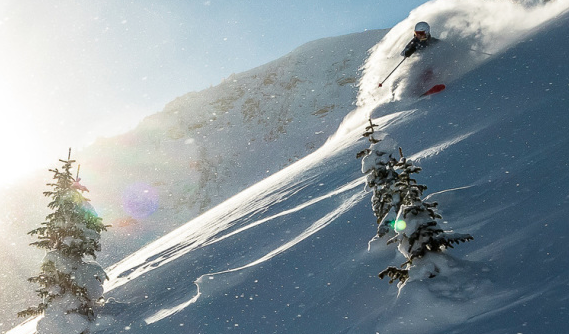
Skiing Weatherman: Season Rolls On in West, New Snow Scarce in East

Fresh Snow in the Wasatch. Spring Conditions Reign East.

This week’s message is quite simple: If you want fresh snow, head west.  If you enjoy spring skiing, the upper Midwest and East will sport those conditions much of the time through the end of the month.  That said, I do expect the East to turn a little colder early in April, but the jet stream may remain benign enough to make it tough to support a storm with fresh snow for the Easter weekend.

As usual, I will point to jet stream features to explain my forecast.  The jet stream is the hand that moves the high and low pressure systems at the surface around like chess pieces.  Here is a look at the jet stream for Wednesday of next week.

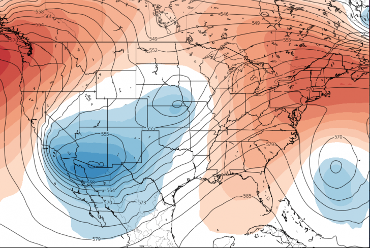
The orange humps that you see in the Pacific Northwest and over the eastern third of the country are ridges, where milder than normal air is located at roughly 15,000 feet above sea level.  Ridges produce warming at the surface, as well as a lack of storminess.  The blue features that look a bit like buckets are troughs, where colder than normal air pools and supports low pressure surface storms that produce snow.  The two lobes of the western troughs will produce snow this weekend into next week from the Sierra into the southern Rockies, and it looks the resorts of the Southwest and Colorado will enjoy another solid dose of powder after the dumping of last weekend.   The Pac Northwest has been the bullseye for much of the heavy hitters this season, but that ridge you see in that region will lead to a relatively quiet week.  No worries – base depths in this part of the country, as well in adjacent Canada, are VERY healthy and can withstand a mild spell with ease.

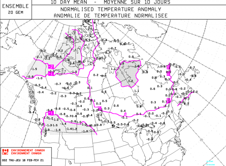
Now, I do think that the trough will consolidate and attempt to move into the East in about 10 days, but any time a trough runs into the back end of a ridge, the trough tends to weaken in terms of circulation and cold air, and be deflected by the ridge.  Here is a look at the jet stream for Monday morning of the 29th with the ridge moving offshore and the trough trying to force its way into the East.

The trough will tend to lift out to the northeast from where it will be on the 29th, rather than bodily move toward the coast, so although we could see a late snow event around the 29th/30th, I don’t believe that it will be a major snowfall. The upper Midwest will stand a better shot at meaningful snow from this system.  As we head through that week and toward Easter weekend, I do think that it will turn cooler in the East, but at this point, I would have to rate a fresh snowfall of significance leading into the holiday a long shot.

If you want fresh snow? Go west.  Sliding in the Midwest or East?  Grab some sunscreen.

REGIONAL HIGHLIGHTS:

Pac NW/B.C.:

Snow falls this weekend into early next week.  Upper ridge develops and leads to dry spell after that.

Central and southern Sierra:

Cold air keeps snow dry this weekend; some light snow early next week with slow warming later in the week as ridge expands down the coast.

Rockies:

Light snow this weekend and again early next week central and north.  Moderate to heavy snow Wasatch and southern resorts from a multi-day storm starting this weekend.

Midwest:

A mild spell settles in this weekend, turning cooler later next week.  Turning colder late next week with improving prospects for snow.

Northeast:

New snow prior to the weekend in the Catskills and Berkshires.  Seasonable temps and dry this weekend. Spring snow conditions rule region-wide next week.

Mid-Atlantic/Southeast:

Nice spring skiing this weekend then mild next week as ridge calls the shots.  Days limited for skiing this season.


Skiing Weatherman: Pattern Quiets Down a Bit

Warmer end to February. March Snow Looks Good.

This has been an absolutely wild weather week across the country, with more heavy snow in the West, the worst run of cold and snow in the southern Plains since 1899, and two significant storms in the East, although the first one generated a fair amount of sleet earlier this week.

As I discussed last week, in the wake of this week’s arctic plunge, the pattern is changing to one with more Pacific air involved, so we are headed toward an end to February that won’t be as cold as much of the month has been.  In terms of the jet stream flow, we will continue to see troughs track across the country and those systems will present us with our shots at fresh snow.  The troughs won’t have quite as much cold air to work with, though, so snow levels could become a minor issue and rain/snow lines will work into the equation with storms in the Midwest and East in the next couple of weeks.  The historic push of arctic air actually drained a good percentage of the available cold air out of Canada.  Yes, it is still plenty cold to the north, but it will take a couple of weeks to build the deep cold that can help sustain the season with a southward push during the month of March.  Here’s a map that I haven’t shown before.  It is a forecast of the standard deviations of temperatures for the next ten days over Canada.


Notice that the values, whether positive or negative, are overwhelmingly close to neutral.  Ten days ago, most of the southern third of Canada, centered over Manitoba and Saskatchewan, had negative values of 5 and 6 standard deviations, consistent with an air mass that was 30+ degrees below normal. That is the air mass that plowed all the way down to south Texas in the past week.  Those values will be dropping in the near term, as it is still the heart of winter to the north.  The question then becomes whether that air will get involved in the pattern over the U.S. in March, when higher sun angles, rising normal temps, and longer days can start to take their toll on surface conditions and base depths.  Right now the prospect for a turn to colder weather looks promising for early March.  Not harsh cold, but a little below normal.  Again, the final week of this month will be milder over the East, while cold persists in the West, but this map of 5,000 foot temperature anomalies for March 5th shows cold air over the East and an ample supply sitting over Canada for reinforcements.  The five thousand foot level is a proxy for surface temps.


So, although the pattern will moderate for the East in the short term, it won’t last long and the prospects for March look good at this point, although a typical La Nina upper ridge could bring the southeastern season to a premature end.  

REGIONAL HIGHLIGHTS:

Pac NW/B.C.:

Snowy pattern carries on. Snow levels rise a bit early next week before settling back down.

Central and southern Sierra:

Light weekend snow, milder during the week of the 22nd.  Pattern cools down and snow opportunities return next weekend.

 Rockies:

Pacific flow brings light to moderate snow every day or two Wasatch and Tetons northward.   Northwest trajectory brings occasional light snow events central and snow is more scarce until late next week farther south.

Midwest:

A little milder than normal and with a few light snow events in the next week in MN, WI, and northern MI.  A great time to hit the slopes, very comfortable.

Northeast:

Not as cold as past few weeks. Weaker Clipper systems bring light mountain snow every few days.  Lower elevation resorts see light mixed precip with surfaces softening/moistening somewhat.

Mid-Atlantic/Southeast:

Light mountain snow 22nd, then milder.  Spring surface develops in all but the highest resorts next week.


Mystery Glimpse: Name That Team

Here’s A Ski Team From The Past.

Can you name when? Who’s who? Thanks to the Colorado Snowsports Museum for this one.

Last Week

Well, last week’s photo was a challenge.  Not one guess. Thanks again to Dana Mathios of the Colorado Snowsports Museum for this description.

This photo was taken at The Hotel Jerome in Aspen. The photo is believed to have been taken in 1948, but some indications from the scrapbook this photo came from indicate a date as early as New Years 1939. The Jerome was built in 1889 and is often described as one of the city’s major landmarks. In 1986 it was listed on the National Register of Historic Places. During Prohibition a celebrated spiked drink, the Aspen Crud, was invented at “J-Bar”. Later, the drink and the bar became popular with members of the 10th Mountain Division while they trained in the area. After the war, Aspen and its new ski resort became a popular destination. Celebrities vacationed in Aspen like Gary Cooper, John Wayne, and Hunter S. Thompson.

The Hotel Jerome: If the walls could talk…Credit: Amuse


Snow In Literature: Lesson #1

Utah Poet Offers Instruction And Advice For Beginners In Sonnet.

The following loosely-rhymed sonnet is by Utah skier and writer Emma Lou Thayne (1924-2014). It appeared in her 1971 book Spaces in the Sage and was once printed on a ski poster sent nationwide to advertise Utah’s “Greatest Snow on Earth.”

Emma Lou Thayne.

Thayne earned a master’s degree in creative writing from the University of Utah after having already established herself as a published writer. For a time she coached the UU women’s tennis team. She was an activist for women, peace, AIDS awareness, and mental health issues, and she was a much-beloved Utah personality and writer.

Her love of skiing Utah powder and her penchant for off-piste adventure is beautifully expressed in this poetic piece of advice to a young beginner. Growing up with three brothers, and raising five daughters, Emma Lou had plenty of opportunities to observe, advise and instruct youngsters in skiing.

Lesson #1

Alta. Credit: SkiUtah

Ski here, my child, not on gentle slopes

where the snow is packed and the trail is wide.

Instead, cut through the trees where no one’s tried

the powder. Push toward the hill and rotate

as you rise. No, the snow-plow holds you back;

it’s slow and makes you frightened of your turn.

Think parallel. Stay all in one, then learn

to ski the fall line, always down: Switchback

skiers in their caution never know how

dropping with the mountain keeps the balance

right and rhythm smooth. Don’t watch your tips at

all. Look past them at the deep white snow,

virgin as light, and yours. Just bend, release:

You, gravity, and white, will make your peace.

Powder Mountain. Credit: Ian Matteson


A Western Tradition Bites The Dust

The “Sniagrab” Is Gone Forever.

Ouch. Another major retail chain bites the dust and with it goes the famous "sniagrab" sales. Credit: Harriet Wallis

Ouch. Another major retail chain bites the dust and with it goes the famous “sniagrab” sales.
Credit: Harriet Wallis

“Sniagrab” is the word “bargains” spelled backwards. More than just a catchy name, Sniagrab was the famous Labor Day blowout sale held by sporting goods retailer Sports Authority. Everything –skis, boards, boots, and all gear and clothing – left over from last season was assembled in a warehouse-type setting and sold at rock bottom prices.

People would wait for hours to be the first through the doors to snatch up the hottest deals. And while waiting in line, there often were handouts and give-aways to stoke the fever. Here in Salt Lake City, many of the state’s 14 resorts had booths and sold season passes at the lowest pre-season prices. Sniagrab was a Labor Day addiction.

Sniagrab created a frenzy that heralded the upcoming ski season. When I lived in New England I chomped at the bit to move West and get to a famous Sniagrab sale. But now the 60-year Sniagrab tradition is kaput, never to happen again.

Sports Authority, a nationwide sporting goods retailer, announced bankruptcy in March and now all 450 stores are closing. Will you experience Sniagrab withdrawal symptoms?