
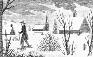
Fact Or Fiction
Test Your Ski Knowledge
- The most ancient ski in existence was found well preserved in a peat bog in China, dating from about 450 AD.
- The furthest anyone has Nordic skied in a 24 hour period is nearly 300 miles.
- In 1918 Denmark had the first “ski army”.
- With about 472, the US has the most ski reports of any country.
- Skiing is available in nearly half the countries of the world.
- The longest ski ever used was over 1,800 feet long.
- The fastest anyone has skied backwards is over 80 mph.
- The most vertical skied in one season is over 6 million feet.
- The longest T-bar in the world is nearly four miles long.
- Though attempted many times, no one has successfully run a marathon in ski boots.
Don’t Peek Yet. Answers Below.
- Fiction: The oldest ski was found in a peat bog but it was in Norway and dates from 2500 BC.
- Fact: Hans Maenpaa of Finland skied 293 miles in 24 hours.
- Fiction: Norway had the first “ski army” in the 1700s.
- Fiction: Japan has the most with about 500.
- Fact: Of the roughly 196 countries in the world about 97 offer skiing.
- Fact: At an event in Norway 170 skiers skied 44 feet on a pair of 1,800 foot long skis.
- Fact: Elias Ambüehl of Switzerland skied backwards at over 80 mph.
- Fact: In the 2014 – 15 ski season Canadian Pierre Marc Jette skied 6,025,751 vertical feet at Whistler Blackcomb. In doing so he raised money for Alzheimer’s treatment and research.
- Fiction: The longest T-bar is at Murray Ridge, BC, Canada. At just under 2.5 miles long it runs at a speed of about 12 mph. To put that in perspective, that’s about the same speed as detachable chairlifts.
- Fiction: Dr. Paul Harnett holds the record; he ran a marathon in ski boots in five and a half hours. Check out this video about his accomplishment:
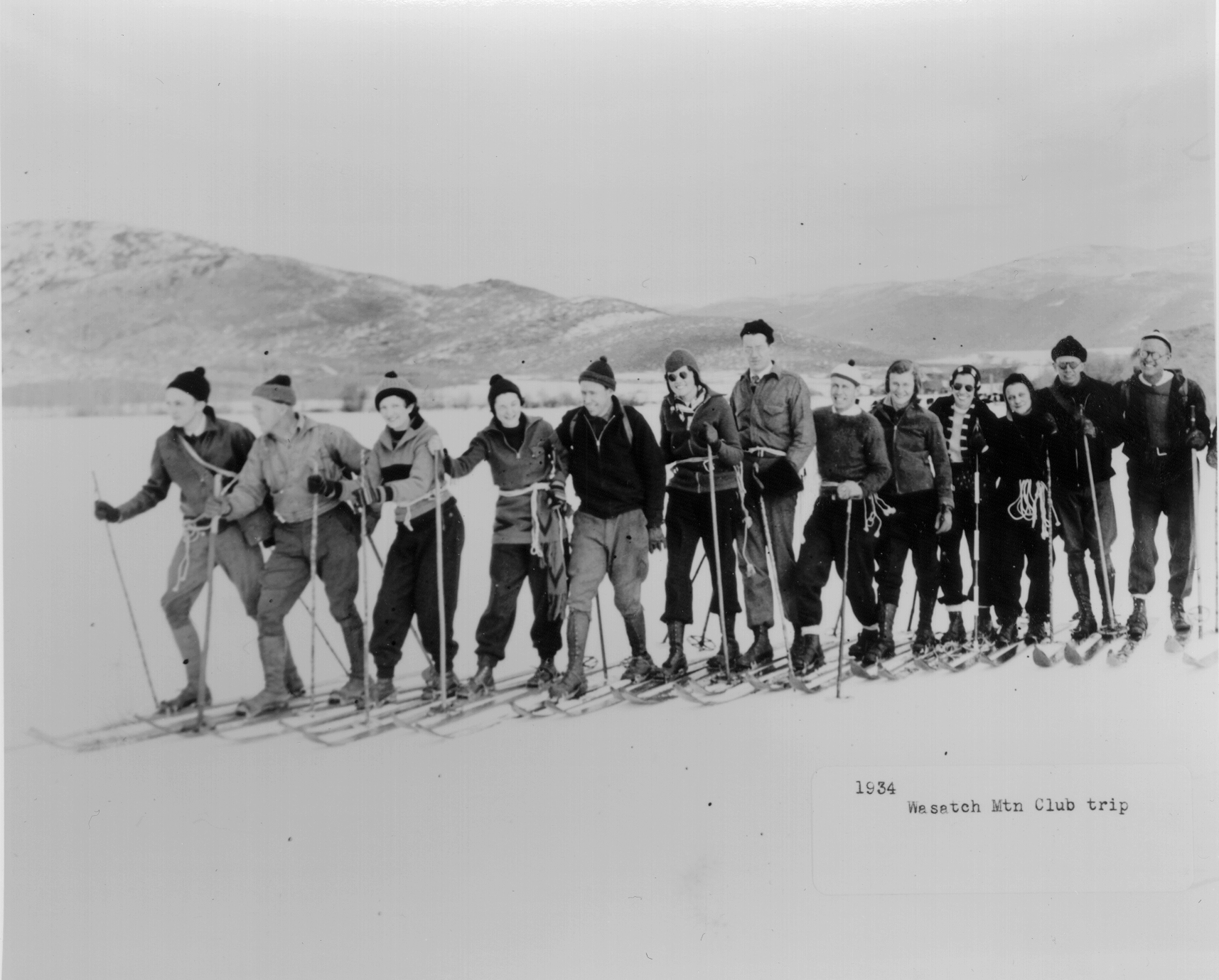
Archives Honors Ski Club And Life-Long Influencer
Alta Icon Alan Engen and Wasatch Mountain Club Earn Top Honors At Ski History gala

Every year, the country’s largest ski history research organization, the Utah Ski Archives, awards honors to movers and shakers in the ski industry.
This year the Wasatch Mountain Club earns the History Maker award for offering outdoor recreation for 100 years. It was founded with just 13 enthusiasts who enjoyed hiking, ski touring, and snowshoeing. A few years later it played a key role in the growth of skiing by offering “ski trains.”
Today it has about 1,000 members, and outdoor activities have changed with the times. The club’s non-competitive, muscle-powered offerings now include river running, mountain biking, back packing, and more. It also focuses on conservation and education.
The coveted S. J. Quinney award goes to Alta’s iconic Alan Engen for his life-long influence on skiing. Engen began as an award winning national and international ski champion, and his dedication to the sport continues to evolve today. He became the Director of Skiing at Alta, he’s in the U.S. Ski & Snowboard Hall of Fame, he’s a ski historian, and he’s authored several in-depth books about skiing. Then he found the Alf Engen Ski Museum in Park City, UT. It’s an interactive, must-see for everyone who visits here.
About the Utah Ski Archives
The Archives collection currently contains 500,000 images, 250 manuscripts and 6,000 audio, video and films. The collection is open to the public and is located in the University of Utah campus library in Salt Lake City. Every year, it holds a gala fundraiser to help support its mission of preserving ski history. And the gala honors individuals and organizations that are a major influence on ski industry.

Award winner Alan Engen smiles next to the photo of him at about age 2 wearing a diaper and ski boots and gleefully holding his first pair of skis. Credit: Harriet Wallis
Skiing Weatherman: Good News Goes West
Jet Stream Changes Bring In the Chills.
Last week I wrote about the “haves and have nots” in terms of favorable early season winter weather. The East was very cold with occasional snow while the West was warm and dry. For the most part, that is still the case, as the eastern Great Lakes and Northeast are in line for a reinforcing shot of arctic air this weekend. Temperatures will be suitable for significant snowmaking Saturday and Sunday. About a half dozen resorts are open in the Northeast, and several more are planning on turning lifts for the first time on Saturday.
The Great Lakes region has had the most consistently cold weather the past couple of weeks. At least a couple of Michigan resorts, Crystal Mountain and Boyne Highlands, will be in operation.
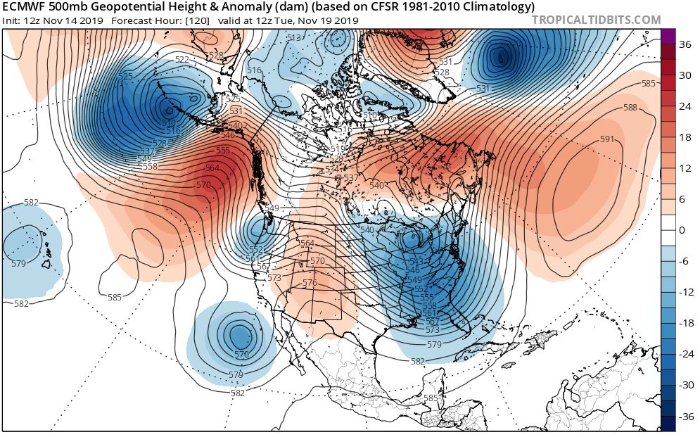
The push of arctic air will be the last for a while, due to some changes in the jet stream configuration over the continent later next week, over the western U.S. in particular. It’s not necessarily bad news in the East, but it certainly is good news for the West. Here is a jet stream forecast map for next Tuesday that helps illustrates the change.
While a deep trough covers the eastern half of the country. I will get to that feature shortly. Notice a shorter wavelength trough along the Washington/Oregon coast. That system will bring snow to the mountains of Alberta and British Columbia, but it looks as though snow levels will be very high in the Cascades of Oregon and Washington. Remember, the waters of the northeast Pacific are quite a bit warmer than normal. That will help the eastern half of the country as we work through winter, but that warm water will tend to elevate snow levels in the Northwest. Now, the other trough along the west coast—west of Baja—will play a role in snow production later next week as the northern and southern branch jet stream features consolidate into a larger trough by next Thursday. Take a look.
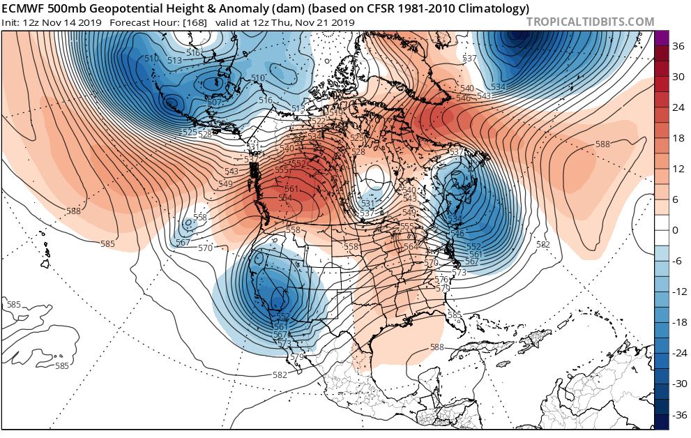
The more organized trough will have both the strength and the moisture to bring a meaningful snowfall to the mountains of the Southwest and the southern and perhaps central Rockies late next week into next weekend.
This map also shows us the subtle changes that will cause the extreme November cold that we have seen in the Lakes and Northeast to back down somewhat as we head toward Thanksgiving. If you recall, last week’s discussion made note of the direct discharge of arctic air from the high latitudes, the product of the combined circulation around a Gulf of Alaska ridge and an eastern trough. That couplet combined for a straight shot from the arctic to the mid latitudes. Look at that flow now on the second map. Start in New York and head west along one of the lines. You will see several changes in direction and eventually you will end up over those temperate waters of the northeast Pacific. Yes, there is still some very cold air involved in the pattern, but Pacific air is blended in, cutting back on the intensity of the cold.
Fear not. The pattern is not going to turn noticeably warmer over the eastern half of the country, but it will turn “less cold”. Temps will still be favorable for nighttime snowmaking, and a storm that works its way up the coast on Tuesday/Wednesday will likely produce some snow in the mountains of New York and northern New England. Meanwhile, after a mild start to November, parts of the West will see some bonafide winter weather in the next week.
[authors_page role=contributor]