

LUV2SKI (con’t)
Isn’t it fantastic what a good imagination can do with six or seven characters…especially when a passion for identifying with skiing is involved?
These new additions to the license plate gallery came from Margery Martin, Minneapolis; Jack Whalberg, Cape Cod, and Hamlin “Ham” Pakradooni, Cape Cod.


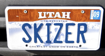

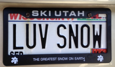

If you run across a skiing license plate and want to add it to the SeniorsSkiing license plate picture gallery, take a picture (preferably close up and straight on) and send it to info@seniorsskiing.com. We’ll do our best to credit each contributor.

The Skiing Weatherman-December 30, 2021
The Skiing Weatherman-December 30, 2021
The West is wonderful…Ol’ Sol causes problems in the East…
After an exceptionally slow start to the season in the West, the past few weeks have brought an amazing and dramatic reversal of fortune to that half of the continent in terms of snowfall. An upper level trough has dominated the pattern from the Rockies to the west coast, and storm after storm has delivered deep Pacific moisture into an air mass cold enough to dump many feet of snow. The holiday week has turned out spectacular in the West, after many resort operators were looking at grassy/rocky slopes just a few weeks ago.
Over the eastern half of the continent, skiers and riders have been waiting impatiently for some of the western cold to flow east so resorts could settle into winter. I thought that the cold would arrive around Christmas and call the shots right into the New Year, but I was wrong. The pattern suggested it would happen, snowy analog years like 1995-96 agreed, and the jet stream configuration around the northern hemisphere pointed toward the evolution of a cold upper trough over eastern North America. And then it didn’t happen. Why not? Well, a rather anomalous spike in the output of the sun might be to blame. When solar flux, or the output of the sun, increases dramatically in winter, it tends to sustain a southeastern U.S. upper ridge, the feature that has thus far kept winter at bay over the Midwest and East. The following map shows the jet setup on the 31st…
You can see two features that are producing the latest rounds of snow in the West…one centered over ID/WA and the other west of Baja California. Over the East, the persistent, troublemaking ridge is still there…in classic La Nina fashion. The ridge has been in place much of the time for a few weeks and it is still there. Here is the graph of solar flux that could explain why the ridge won’t relent and let cold shots penetrate deeper into the East…

The red line on the graph is solar flux, and you can see that it increased dramatically around mid-December. There is a lag time of a few weeks with this phenomenon, which explains why the ridge won’t budge and keeps deflecting low pressure centers through the eastern Great Lakes and up into Canada…an unfavorable track for cold and snow in the Northeast. But also notice that it is now weakening, so I believe that cold shots will have an easier time knocking down the ridge in the weeks to come. The change won’t happen overnight, but I expect disturbances that press eastward out of the western troughs will start to break down the ridge, starting with a body shot the weekend of the 1st/2nd. The ridge will fight back, but by mid-month, cold should rule across the north from the Lakes to the Northeast, and the mid-Atlantic and Southeast should be in a more favorable pattern by then, as well.
Here are regional highlights…
Northwest U.S./Western Canada: Snowfall takes a time-out this weekend, but resumes during the first week of the New Year.
Sierra: Nice weekend to enjoy all the new snow. Snow returns next week…higher totals to be found north of I-80.
Rockies: Cold weekend with diminishing snows. After a couple of quiet days, the parade of storms resumes early to midweek.
Midwest: Cold weekend with snow in lake effect belts. Clipper brings snow midweek. Pattern turning colder overall.
Mid Atlantic/Southeast: Rain changes to snow this weekend. Cold shot supports productive snowmaking early in the week.
Northeast/QB: Messy weekend turns much colder. Great snowmaking early in the week. Prospects improving for meaningful snow late next week.
This Issue
This is being written from Salt Lake City, the day after 20” fell at Snowbird. It’s almost at the top of Little Cottonwood Canyon and just a short distance from Park City, where the total was 10”. Compare that to Mammoth Mountain in California’s Sierra range… 44” in 72 hours!
Jon’s Short Swings! column is a bit self-confessional this time, speaking to the factors that help us age gracefully. As usual, it also reports on industry news and recent curiosities. The link to a history of how snowball fights have been shown in art shouldn’t be missed.
Herb Stevens, the Skiing Weatherman, reports on winners and losers in the most recent storm cycles. His articles are always good reading.
We really should appreciate our ski buddies because, as we age, they become like hen’s teeth. Harriet Wallis advises how to find others with whom to ski.
Longtime ski instructor, John Gelb, addresses a common and often undiscussed issue among skiers of all ages: fear. He offers good guidance on conquering what he calls, the Fear Monkey.
Contributor Pat McCloskey, who is accustomed to skiing in his home state of Pennsylvania, explains how to use smaller mountains to hone skiing skills for trips to bigger terrain. Pat has skied them all and offers readers excellent counsel.
XC editor, Roger Lohr, presents 10 places around the country where XC beginners can learn the basics.
The winner of our last Test Your Skiing Knowledge feature is presented along with the new challenge. Remember, first correct answer mailed to jon@seniorsskiing.com wins the prize.
And, thanks to the contributions from numerous readers, the ski-oriented vanity license plate photo gallery has expanded.
Enjoy the issue. Have a great Holiday Season. Next issue: January 7.
[authors_page role=contributor]