

The Skiing Weatherman February 10, 2023
In spite of last weekend’s dramatic cold outbreak over the Northeast, one that was muted at resorts further south in the mid-Atlantic states, milder than normal temperatures continue to dominate the pattern. Not to the extent that they did in a very mild January, but enough to make every disturbance, big or small, that comes along a real nail biter in terms of rain vs. snow. For the most part, natural snow has been confined to areas north of Interstate 90 in New York and New England, although the Catskills have cashed in a few times here in there before seeing mild air turn the precip over to something other than flakes. There is no short-term change in sight, but all is not lost. An infrequent event at the top of the atmosphere over the high (polar) latitudes is underway, and I believe that this phenomenon may well provide the Northeast with its most consistent snow conditions of this season from late this month through at least a good portion of March.
What’s going on high above the arctic regions is known as a Sudden Stratospheric Warming, or SSW. At the top 1 to 3 per cent of the atmosphere, at roughly 30 miles above the surface, the air is warming rapidly, and as pressure levels grow aloft, the effect is gradually pressing down on the polar vortex that is swirling around closer to the surface at a level known as the troposphere. Here is a graphic that illustrates the potential “before and after” of the process…
You can see the tight, symmetrical circulation over the North Pole, which is essentially what the vortex looks like right now. The squiggly darkest blue line is what the vortex will look if the warming fully matures, spreads to the lower levels and breaks it up. As the warming continues to descend, the vortex is attacked by the warmth at the top of the atmosphere. Here is a graphic showing the attack at the top for the 17th…

A strong bubble of warmth has pushed and distorted the vortex to the east…off its polar perch. This next map shows the stratospheric temperatures the next day at well above normal levels…

As the process continues, the smooth and nearly circular flow of the vortex will get disrupted, so instead of having most of the cold air in the northern hemisphere bottled up near the North Pole, some of that air will get redistributed to the lower latitudes. One of the key indicators if the warming and vortex disruption is enough to bring the Northeast a spell of consistently cold and snowy weather will be a change in direction of the flow around the pole. Modeling does indeed forecast that change, and if it does occur, studies of prior SSWs tell us that although the main thrust of the coldest air will move into Siberia, an upper-level trough will form over eastern North America for an extended stay. In that position, the trough will be poised to receive several shots of cold air from Siberia via a track up and over the Pole. Here is a look at where the jet stream set up is headed toward the end of this month and beyond…

The most recent February SSW event of consequence was in 2018, and it is worth looking at the temperature anomalies at the surface that occurred in March and April of that year…

Typically, the cold effects of an SSW event last several weeks, and when combined with a dying La Nina, even longer.
An SSW is a very complex event and I hope I have been able to adequately describe it in the space available. With another week of marginal temps about to unfold in the Northeast and the specter of yet another messy “cutter” storm moving up to the west of the region late next week, I chose to discuss the SSW today because I believe that there will be outstanding conditions to enjoy before this season is over. The SSW that is underway is the meteorological mechanism that will get us there.
ICYMI February 2023
There’s so much happening at ski/snowboard/XC resorts this season, so we are alerting you to these special events to put on your calendar in February. The list includes world-class racing and a mountaintop art exhibit.
ICYMI (in case you missed it):

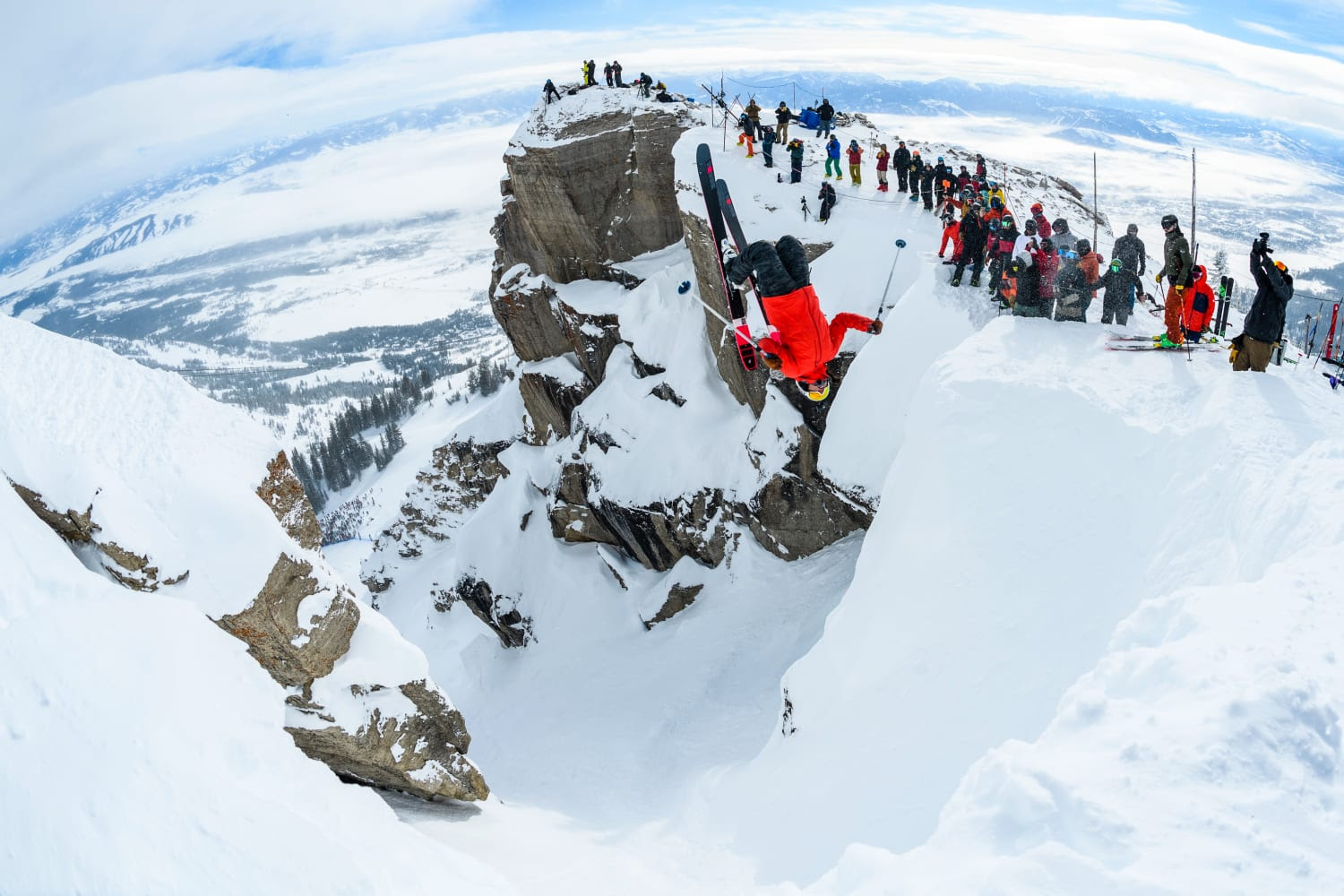
JH Kings and Queens of Corbets Veronica Paulson first womans backflip
Kings and Queens of Corbet’s Competition at Jackson Hole
This impressive competition debuted in 2018, featuring equal prize money in an athlete-judged event with adrenalin-charged moves such as double backflips, nose butters and other high-flying tricks. huge methods.
Now in its 6th year, the famous Kings and Queens of Corbet’s competition returns February 4 – 11, amid some of the best snow conditions in decades at JHMR. The resort has reported more than 260 inches of snowfall this season to date, and the Kings and Queens competition is part of a full slate of Royal Week events planned for visitors during the week including athlete appearances, autograph signings, daily apres and exclusive parties.
“There is nothing more mind-blowing than watching athletes send 60-foot tricks that will change what you thought was possible. And the best way to experience all of it is in person at the base of Corbet’s Couloir in Tensleep Bowl,” says Jess McMillan, Director of Events and Partnership at Jackson Hole Mountain Resort.
This year’s roster of athletes confirmed to appear at Kings and Queens of Corbet’s includes skier and two-time king Karl Fostvedt (2018, 2021) and 2020 champion Parkin Costain, reigning queen Piper Kunst and 2020 women’s champion Veronica Paulsen. For more information, visit www.jacksonhole.com.
Also see our recent article on where to ski and what to do in Jackson Hole. https://seniorsskiing.com/seniorsskiing-guide-jackson-hole-not-for-experts-only/
Ullr Nights Celebration at Snowmass
Celebrate the Norse god of winter and embrace the cold under the stars with Ullr Nights, a winter party at Elk Camp on Snowmass. Ride the gondola up, have dinner inside from 5:30-7:30pm, then head out for tubing, laps on the Breathtaker Alpine Coaster, snowbiking and s’mores and hot coca next to a roaring bonfire.
Ullr Nights are February 15 and 24 and March 17 and 24. Reservations arerecommended. Tickets are $67 for unlimited tubing and coaster rides or $12 general admission to the bonfire. Both include the gondola ride to and from Elk Camp.
https://www.aspensnowmass.com/visit/activities/winter/ullr-nights
World Pro Ski Tour at Bear Valley
The World Pro Ski Tour (WPST) returns to this California resort Feb. 10-12, with two men’s and two women’s races on the same course and with equal prize money.
Bear Valley has a rich history with WPST, hosting such renowned skiers as 3x Olympic Gold Medalist Jean Claude Killy and World Champion and Olympic Silver Medalist Billy Kidd. This year, returning champions include Tour Champions Rob Cone and Tuva Norbye, along with a field of international pro racers. There has been skiing at Bear Valley since 1855.
Race dates and times are as follows:
Feb. 10th – 10am – Qualifiers.
Feb. 11th and 12th – 11am – Men’s & Women’s Giant Slalom Races & 3:30pm Tito’s Après Party
Find more information at www.WorldProSkiTour.com. Watch live at www.FloLive.tv
 Art at the Summit in Courchevel
The 14th annual Art at the Summit show features huge bronze sculptures by the award-winning artist Lorenzo Quinn, the son of Academy Award-winning actor Anthony Quinn. The works are on display all season, gracing the summits, the heart of the multi-summit resort, and at the Galerie Bartoux Courchevel, which is sponsoring the exhibit.
Lorenzo Quinn’s monumental sculptures have been exhibited at the Pyramids of Giza in Egypt, the canals of Venice and the parks of London. This is his first exhibit in the Alps. The sculptures are described as gravity-defying, poetic and true odes to love, including Quinn’s love of the outdoors.
Ikon Celebrates an Icon
When she wins, you win.
Mikaela Shiffrin,World champion alpine skier and Ikon Pass ambassador, just reset the world record for the most all-time World Cup wins for any female skier in history with 83 gold medals, and there are still several more races left in the season for her to add to the total.
To celebrate her milestone, Ikon Pass is giving away three ski packages for the 23/24 ski season at one of ten Ikon Pass destinations –
![]()
- Mammoth Mountain and Palisades Tahoe in California
- Solitude Mountain Resort and Snowbird in Utah
- Sun Valley Resort in Utah
- Revelstoke Mountain Resort and SkiBig3 in Canada
- Killington Resort inVermont.
Each prize package includes –
- Three nights lodging and rentals
- Ikon Pass jacket and bag
- 2023/2024 Ikon Pass
- Mikaela Shiffrin Oakley goggles
- Full adidas Terrex ski kit including jacket and bibs
- Signed item from Mikaela
- Message from Mikaela
Here’s how to enter to win:
- Visit https://bit.ly/IkonMikaela
- Complete at least 83% of Mikaela’s trivia correctly
- Enter your name and email address
- Winner will be drawn by the end of the 2023 World Cup season.
And, in the meantime, practice your own race skills and dream of joining the U.S. Ski and Snowboard team by visiting a NASTAR course for FREE through the end of the current winter season. Just present a valid lift ticket or pass – either an Ikon Pass or a resort specific pass.
Did we miss anything on your calendar? Please add to the comments section.

The Skiing Weatherman January 27, 2023
In this installment I am going to hit three topics for the price of one. First, I had a day on the snow last week that I don’t think I will ever forget. I was in Salt Lake City for a trade show and snuck away to Park City for a day. It is the first time I have been there since Park City Mountain Resort was combined with The Canyons. The resulting seven mile WIDE network of trails, slopes and tree skiing is hard to fathom, but so was the amount of snow. I haven’t seen that much snow on a mountain since I was (happily) stuck in four day storm in Austria more than 35 years ago. Practically every turn made off the groomers last week was high shin to waist deep…just remarkable stuff. And a hats off to Jonathan, the manager at Canyon Mountain Sports, who guided me to the fattest ski that I had ever used…and they worked like a charm!
Second, I need to sound off on something that has bugged me for some time. Many of you know that I have been a snow condition reporter for almost 40 years now. Along the way, I ran into some rather nefarious forms of snow reporting, where the “new snow” numbers didn’t match very well with Mother Nature’s output. Well, the inaccuracies and obfuscation reached a new low this morning as I checked out the results of an overnight storm that started with a thump of snow across most of the Northeast but ended with a variety of precip types, including some rain, all the way to far northern New England. I wanted to sneak in a late week day trip and was checking out “who got what” overnight. I consulted the largest web site for snow conditions in the world (and to quote Billy Crystal’s Fernando from SNL…”and you know who you are”…) and what I found was in simple terms, a mess.
One column of the reports is dedicated to “Snowfall” and maybe that’s part of the problem as it should say “NEW Snowfall”. You see, just about the entire region got 2 to as much as 9 inches of snow…before the other stuff came out of the sky. I wanted to use the reports to determine the northern extent of where the garbage cut down on the snow total and then make a decision on a destination for the next day. Unfortunately, the snowfall listed in the report ranged from 1 to 20 inches because the resorts listed snowfall for the past 1,2,3,4,5,6,or 7 days…there was absolutely no uniformity to the reports!!! And I am not even taking into account that two other storms in the prior seven days also had other forms of precip. Between the fact that there is no accounting for any sleet, freezing rain, or plain rain…as though it never happens…and the resorts seem to use any time frame they want, it makes it next to impossible to make an informed decision based on the reporting system as it is presented. And I haven’t even included the practice of reporting one snowfall total for vertical drops of 1 to 3 thousand feet…funny, they always use the higher number from the summit. Anyway, Caveat Emptor…we deserve better.
On to #3…the weather…and I will be briefer than usual. The pattern has been changing to a colder one over the Northeast, but it has been slow…slower than I thought it would be a few weeks ago. But, it IS changing. This next week will see the temps trend down, but in terms of snowfall, there will only be weak systems racing from west to east, producing only snow showers with light accumulations in the mountains. The week of the 6th will be colder than normal, and this frame of the jet stream shows part of the reason why…
This jet stream forecast for Sunday the 5th shows a direct feed of air from the northwest corner of the continent. Counterclockwise flow around the trough over northeastern Canada is going to combine with clockwise circulation around the ridge building northward toward the Yukon, where the air is arriving from Siberia. Here is a forecast for the temperature anomalies at 5,000 feet at that same time stamp…these temps act as a proxy for surface temps…

You can easily see the glide path from the Yukon to the Northeast on this slide. Now, there is some risk of an extreme cold outbreak during the first half of February, but at a minimum, we shouldn’t have to worry about rain vs. snow too much early next month. Longer term, I am bullish on the second half of the season and I will delve into that topic next time. I know Festivus was last month, but thank you for the space for the Airing of Grievances…
[authors_page role=contributor]