

New Golf: Ready For A Fling?
Snowboarding:Skiing as Fling Golf:Golf.
https://www.youtube.com/watch?v=zVDUq1Rqd10
We love sport entrepreneurs. These folks are creative and have bold ideas about bringing new sport ideas to the public. The guy who invented Fling Golf is certainly bold.
Into the hallowed traditions of the golf world comes a very different way to get around the links. The idea is to fling a golf ball from a device that has a close resemblance to a lacrosse stick. Instead of hitting the ball with a golf club, you flip it down the fairway. Same basic game, different equipment.
The premise is that it is an easier game to play than “real” golf, and more people can be attracted to golf courses. More people would be a good thing because golf participation has fallen and leveled off since a high in 2003.
How this will go over with 1) other golfers and 2) golf course management is yet to be determined. Do flingers share the course with clubbers? Do clubbers let flingers into the sanctum sanctorum golf clubs (think Augusta, The Country Club in Brookline, MA, Pebble Beach, St. Andrews)? Do we have the Alta version of golf courses? (Alta doesn’t permit snowboarders). Is that good or bad?
It is interesting how a new way of playing an old sport causes one to reflect on the nature of change.
What do you think, golfers? Are you ready for a fling?
Same game, different gear. Are you ready to share the links?
Credit: Fling Golf
Adios, El Nino, Hola, La Nina
Big Changes Are Coming Again To Next Season’s Weather.
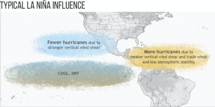
The image above shows how the sea surface temperature is changing from warm to cooler, signaling the advent of a La Nina event.
Weather scientists are predicting that the sea surface temperatures in the Eastern Pacific will continue to drop, ending the extraordinary, record-breaking El Nino conditions that drove so much of last winter’s weather. When the sea surface water temps drop below .5 degrees C off the coast of Peru, the new La Nina will be in the wings, bringing yet another set of changes to next ski season’s weather. Some reports predict this La Nina can be as dramatically cold as the fading El Nino was warm.
During the summer coming up, the first impact you’ll see will be more hurricanes in the Atlantic. The hurricane season in the Atlantic starts on June 1 and goes to November 30. The prediction is for more storms because of weaker upper level winds.
For the winter months, a typical La Nina pattern will be cool weather in the Northwest, warm and dry across the southern border, and a wet East. Click here for an interesting discussion from the Weather Network.
Fun Fact: La Ninas last longer than El Ninos. The La Nina event that followed the the 1997/98 El Nino lasted 33 months!
Here’s a more technical discussion from NOAA.
Stay tuned for more updates as we watch how La Nina takes shape and how it will impact next winter’s weather.
The first La Nina impact could be more frequent Atlantic hurricanes. This year’s La Nina is predicted to be as cool as last year’s record-breaker El Nino was warm.
Credit: NOAA

Cycling Series: Rolling Among The Rocks At Arches
Once Past The Crowds, Another World Opens Up.
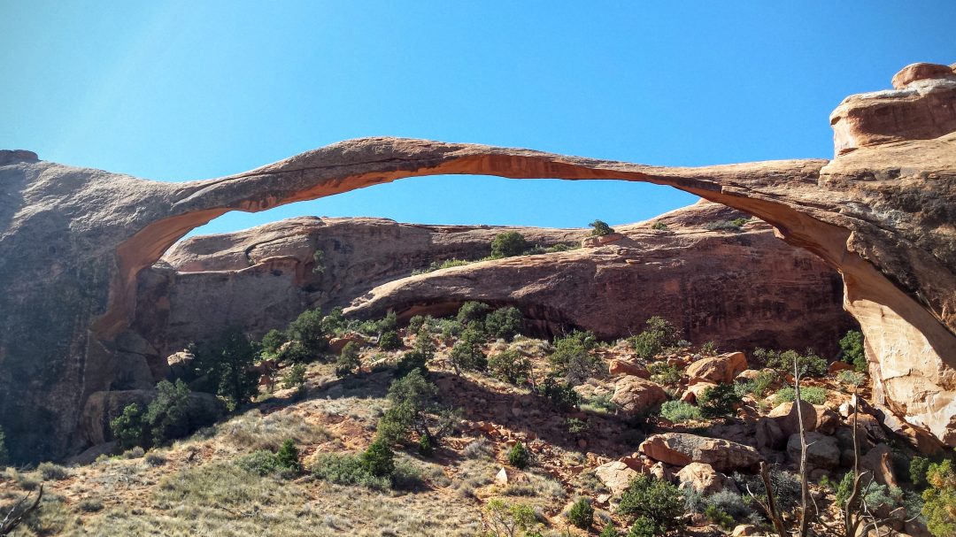
Landscape arch in the Devils Garden Trail in Arches National Park.
Credit: John Nelson
Looking out the window of a car just can’t capture the otherworldly beauty of Arches National Park in Utah.
In this stark and dramatic landscape of towering spires, delicate arches and balanced rocks, I chose to bike and hike on my pathway to discovery.
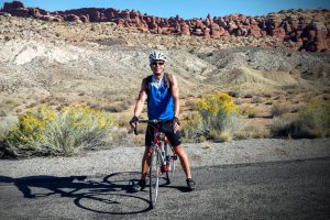
John Nelson along the Fiery Furnace Trail.
Credit: John Nelson
I visited Arches in Fall 2015. I pulled into the nearby town of Moab in the evening and found that things were hopping among a diverse crowd of cyclists, hikers, river-runners, ORV enthusiasts and vacationers, all with plans to recreate in the rugged region.
I decided to start early the next morning to get a jump-start on the crowd.
So much for solitude. My outdoors-loving brethren had the same idea, and we all got stuck in a long backup at the Arches entrance gate. Arches National Park is a popular place with nearly 1.4 million people visiting last year.
Once through the entrance, I parked a couple of miles from the visitor center, climbed aboard my bike, and happily left my car behind. The roads were initially busy, but after a few miles, things calmed down and traffic dispersed, leaving me to pedal among the wide-open vistas.
What I saw over the next few hours was mind-blowing.
The National Park lies atop an underground salt bed. Over millions of years, the salt bed became unstable, eroded and shifted, leaving dramatic rock features carved by wind and weather that remain today.
My ride along the main road passed some of the very best sights in the park to its end at Devils Garden 18.5 miles from the entrance gate. Some side roads take visitors to other arch locations, but I wanted to go as far as I could inside the park and return later to see the other attractions.
The ride to Devils Garden takes place on rolling terrain between elevations of 4,500 and 5,500 feet. Once at Devils Garden, I slipped on hiking shoes to visit some of the park’s most famous arches along a 7.2-mile loop trail.
After a picnic lunch, I climbed back on my bike to head back. In some ways, the return ride was even better than the ride out. The light had changed, giving me a different view of these amazing formations.
Back at the car, I was exhausted from the ride and hike—and utterly satisfied. I had seen the park in way that author Edward Abbey, a former park ranger at Arches, would certainly appreciate.
“A (traveler) on foot, on horseback or on a bicycle will see more, feel more, enjoy more in one mile than the motorized tourists can in a hundred miles,” Abbey wrote in Desert Solitaire.
If you go:
Where to start the ride: Don’t park at the visitor center, which is usually swarming with tourists. Instead, drive 2.5 miles inside the park to the La Sal Mountains Viewpoint parking lot. By doing so, you’ll get out of the high-traffic area, and you’ll also avoid a 1,000 vertical foot climb.
When to visit: Spring and Fall, with more moderate temperatures, are the best times to see Arches. Summer temperatures can soar above 100 degrees.
Fitness concerns: At about 30 miles, the ride is difficult, but has only a couple of climbs. Much of the terrain is rolling and pleasant. Carry ample water, and you can refill at Devils Garden.
Safety: Even with traffic, I never felt unsafe riding at Arches. The roadways have good shoulders, and I found that drivers were mostly courteous and careful.
Food: Arches has no food concession, so pack along anything you want to eat. Moab has a wide array of restaurants and markets where you can stock up.
Highlights: Almost too many to count. The Courthouse Towers Viewpoint, The Great Wall, Balanced Rock, Panorama Point and Fiery Furnace all are along the road. If you have the energy, consider a hike around Devils Garden to see some of the park’s best sights.
Accommodations: Moab is the place. You’ll find a wide selection of condos, motels, resorts and bed and breakfasts.
Camping: The Devils Garden Campground inside the national park has 52 spaces, but these fill up very quickly. Don’t arrive thinking you’ll get lucky. Reserve a spot ahead by clicking here or by calling (877) 444-6777. Outside of Arches, there are several other options, including Willow Flat Campground in Canyonlands National Park and Dead Horse State Park, as well as primitive BLM campsites along the Colorado River. Click here for details.
Click here for maps of the area.
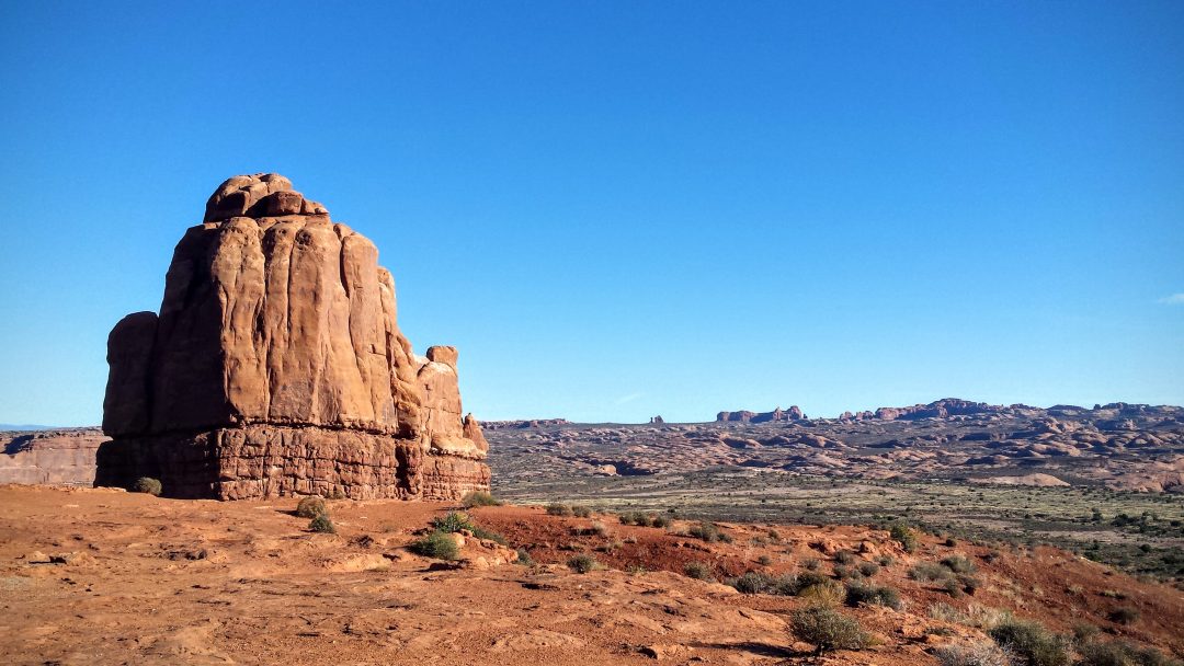
Tower of Babel watches over Arches National Park, UT.
Credit: John Nelson
[authors_page role=contributor]